Recorded for: Cathedral Lakes JMT mapped connector
- Distance status
- not printed
- Route role
- official mainline
Evidence and sources (1)
No claim effective interval recorded.
Spatial scope IDs: scope-tuolumne-meadows
Evidence stance: supports · Evidence details
Evidence notes: Official map confirms route membership and junction sequence.
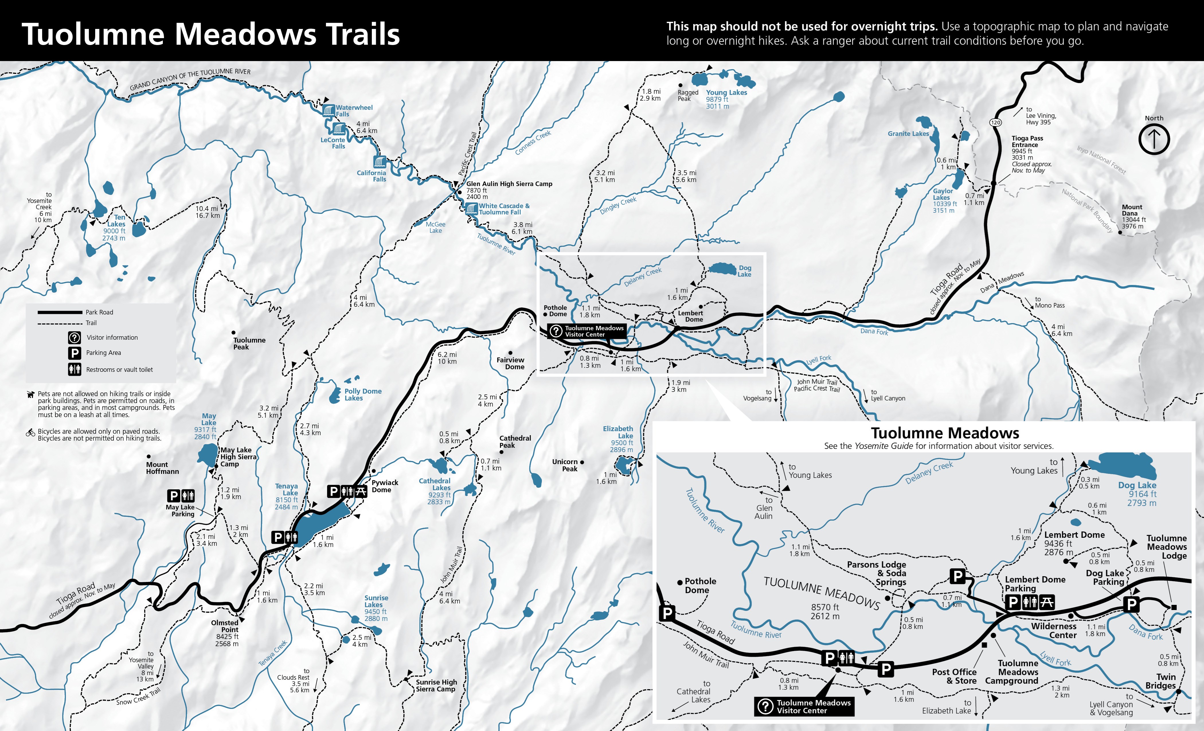
The official 2024 Tuolumne Meadows Trails map shows the day-hike trail network, junctions, destinations, parking, restrooms, and printed leg mileages. It warns that the map is not for overnight trips and advises asking a ranger about current conditions.
- Publisher
- National Park Service
- Observer / attribution
- Not recorded
- Observed at
- Unknown
- Retrieved at
- 2026-09-25T00:00:00+00:00
Retrieval time does not establish when an event occurred.
Observation details · Source details · Original source: National Park Service
Recorded for: Dog Lake lower mapped connector
- Distance status
- not printed
- Route role
- official mainline
Evidence and sources (1)
No claim effective interval recorded.
Spatial scope IDs: scope-tuolumne-meadows
Evidence stance: supports · Evidence details
Evidence notes: Official map confirms route membership and junction sequence.
The official 2024 Tuolumne Meadows Trails map shows the day-hike trail network, junctions, destinations, parking, restrooms, and printed leg mileages. It warns that the map is not for overnight trips and advises asking a ranger about current conditions.
- Publisher
- National Park Service
- Observer / attribution
- Not recorded
- Observed at
- Unknown
- Retrieved at
- 2026-09-25T00:00:00+00:00
Retrieval time does not establish when an event occurred.
Observation details · Source details · Original source: National Park Service
Recorded for: Lembert parking to PCT connector
- Distance status
- not printed
- Route role
- official mainline
Evidence and sources (1)
No claim effective interval recorded.
Spatial scope IDs: scope-tuolumne-meadows
Evidence stance: supports · Evidence details
Evidence notes: Official map confirms route membership and junction sequence.
The official 2024 Tuolumne Meadows Trails map shows the day-hike trail network, junctions, destinations, parking, restrooms, and printed leg mileages. It warns that the map is not for overnight trips and advises asking a ranger about current conditions.
- Publisher
- National Park Service
- Observer / attribution
- Not recorded
- Observed at
- Unknown
- Retrieved at
- 2026-09-25T00:00:00+00:00
Retrieval time does not establish when an event occurred.
Observation details · Source details · Original source: National Park Service
Recorded for: Meadow crossing connector
- Distance status
- not printed
- Route role
- official mainline
Evidence and sources (1)
No claim effective interval recorded.
Spatial scope IDs: scope-tuolumne-meadows
Evidence stance: supports · Evidence details
Evidence notes: Official map confirms route membership and junction sequence.
The official 2024 Tuolumne Meadows Trails map shows the day-hike trail network, junctions, destinations, parking, restrooms, and printed leg mileages. It warns that the map is not for overnight trips and advises asking a ranger about current conditions.
- Publisher
- National Park Service
- Observer / attribution
- Not recorded
- Observed at
- Unknown
- Retrieved at
- 2026-09-25T00:00:00+00:00
Retrieval time does not establish when an event occurred.
Observation details · Source details · Original source: National Park Service
Recorded for: Pothole Dome parking-to-path connector
- Distance status
- not printed
- Route role
- official mainline
Evidence and sources (1)
No claim effective interval recorded.
Spatial scope IDs: scope-tuolumne-meadows
Evidence stance: supports · Evidence details
Evidence notes: Official map confirms route membership and junction sequence.
The official 2024 Tuolumne Meadows Trails map shows the day-hike trail network, junctions, destinations, parking, restrooms, and printed leg mileages. It warns that the map is not for overnight trips and advises asking a ranger about current conditions.
- Publisher
- National Park Service
- Observer / attribution
- Not recorded
- Observed at
- Unknown
- Retrieved at
- 2026-09-25T00:00:00+00:00
Retrieval time does not establish when an event occurred.
Observation details · Source details · Original source: National Park Service
Recorded for: Cathedral Lakes trailhead approach
- Distance status
- not printed
- End coordinate
- Latitude
- 37.87263365091298
- Longitude
- -119.37470605940318
- Geometry snapshot
- Feature id
- nps-trail-22787
- Path
- geometry/v0/snapshots/nps-yose-tuolumne-route-features-20260925.geojson
- Sha256
- d53d6a93e218c53b4e74f2e134bdcc7d97f4f8cc132c56979d650a6851a14069
- Route role
- official mainline
- Source feature id
- 22787
- Source feature name
- Unknown
- Source geometry id
- {91FFD051-54D9-4347-8F7E-F619EF5577B6}
- Start coordinate
- Latitude
- 37.872050084344906
- Longitude
- -119.38181746250602
Evidence and sources (2)
No claim effective interval recorded.
Spatial scope IDs: scope-tuolumne-meadows
Evidence stance: supports · Evidence details
Evidence notes: Official map confirms route membership and junction sequence.
The official 2024 Tuolumne Meadows Trails map shows the day-hike trail network, junctions, destinations, parking, restrooms, and printed leg mileages. It warns that the map is not for overnight trips and advises asking a ranger about current conditions.
- Publisher
- National Park Service
- Observer / attribution
- Not recorded
- Observed at
- Unknown
- Retrieved at
- 2026-09-25T00:00:00+00:00
Retrieval time does not establish when an event occurred.
Observation details · Source details · Original source: National Park Service
Evidence stance: supports · Evidence details
Evidence notes: NPS Public Trails feature 22787 supplies reviewed display geometry.
Reviewed NPS Public Trails features provide the displayed line geometry and source feature identifiers for nine Tuolumne day-hike graphs selected against the official map.
- Publisher
- National Park Service
- Observer / attribution
- Not recorded
- Observed at
- Unknown
- Retrieved at
- 2026-09-25T00:00:00+00:00
Retrieval time does not establish when an event occurred.
Observation details · Source details · Original source: National Park Service
Recorded artifact references
geometry/v0/snapshots/nps-yose-tuolumne-route-features-20260925.geojson
References are not a confirmation of current availability.
Recorded for: John Muir Trail to Upper Cathedral Lake
- Distance status
- not printed
- End coordinate
- Latitude
- 37.87203926219901
- Longitude
- -119.3838255028351
- Geometry snapshot
- Feature id
- nps-trail-20885
- Path
- geometry/v0/snapshots/nps-yose-tuolumne-route-features-20260925.geojson
- Sha256
- d53d6a93e218c53b4e74f2e134bdcc7d97f4f8cc132c56979d650a6851a14069
- Route role
- official mainline
- Source feature id
- 20885
- Source feature name
- John Muir Trail
- Source geometry id
- {2A1879B2-EA08-4362-9E7B-1583C05916AC}
- Start coordinate
- Latitude
- 37.851377321010254
- Longitude
- -119.4149621795829
Evidence and sources (2)
No claim effective interval recorded.
Spatial scope IDs: scope-tuolumne-meadows
Evidence stance: supports · Evidence details
Evidence notes: Official map confirms route membership and junction sequence.
The official 2024 Tuolumne Meadows Trails map shows the day-hike trail network, junctions, destinations, parking, restrooms, and printed leg mileages. It warns that the map is not for overnight trips and advises asking a ranger about current conditions.
- Publisher
- National Park Service
- Observer / attribution
- Not recorded
- Observed at
- Unknown
- Retrieved at
- 2026-09-25T00:00:00+00:00
Retrieval time does not establish when an event occurred.
Observation details · Source details · Original source: National Park Service
Evidence stance: supports · Evidence details
Evidence notes: NPS Public Trails feature 20885 supplies reviewed display geometry.
Reviewed NPS Public Trails features provide the displayed line geometry and source feature identifiers for nine Tuolumne day-hike graphs selected against the official map.
- Publisher
- National Park Service
- Observer / attribution
- Not recorded
- Observed at
- Unknown
- Retrieved at
- 2026-09-25T00:00:00+00:00
Retrieval time does not establish when an event occurred.
Observation details · Source details · Original source: National Park Service
Recorded artifact references
geometry/v0/snapshots/nps-yose-tuolumne-route-features-20260925.geojson
References are not a confirmation of current availability.
Recorded for: Dog Lake final spur
- Distance status
- not printed
- End coordinate
- Latitude
- 37.89082712285851
- Longitude
- -119.3437727704019
- Geometry snapshot
- Feature id
- nps-trail-15981
- Path
- geometry/v0/snapshots/nps-yose-tuolumne-route-features-20260925.geojson
- Sha256
- d53d6a93e218c53b4e74f2e134bdcc7d97f4f8cc132c56979d650a6851a14069
- Route role
- official mainline
- Source feature id
- 15981
- Source feature name
- Dog Lake Trail
- Source geometry id
- {0F97CF43-C130-46F8-A7D4-C7E8A18C5799}
- Start coordinate
- Latitude
- 37.88841500945351
- Longitude
- -119.34623621953024
Evidence and sources (2)
No claim effective interval recorded.
Spatial scope IDs: scope-tuolumne-meadows
Evidence stance: supports · Evidence details
Evidence notes: Official map confirms route membership and junction sequence.
The official 2024 Tuolumne Meadows Trails map shows the day-hike trail network, junctions, destinations, parking, restrooms, and printed leg mileages. It warns that the map is not for overnight trips and advises asking a ranger about current conditions.
- Publisher
- National Park Service
- Observer / attribution
- Not recorded
- Observed at
- Unknown
- Retrieved at
- 2026-09-25T00:00:00+00:00
Retrieval time does not establish when an event occurred.
Observation details · Source details · Original source: National Park Service
Evidence stance: supports · Evidence details
Evidence notes: NPS Public Trails feature 15981 supplies reviewed display geometry.
Reviewed NPS Public Trails features provide the displayed line geometry and source feature identifiers for nine Tuolumne day-hike graphs selected against the official map.
- Publisher
- National Park Service
- Observer / attribution
- Not recorded
- Observed at
- Unknown
- Retrieved at
- 2026-09-25T00:00:00+00:00
Retrieval time does not establish when an event occurred.
Observation details · Source details · Original source: National Park Service
Recorded artifact references
geometry/v0/snapshots/nps-yose-tuolumne-route-features-20260925.geojson
References are not a confirmation of current availability.
Recorded for: Dog Lake lower trail
- Distance status
- not printed
- End coordinate
- Latitude
- 37.87962145814533
- Longitude
- -119.33903292733334
- Geometry snapshot
- Feature id
- nps-trail-21543
- Path
- geometry/v0/snapshots/nps-yose-tuolumne-route-features-20260925.geojson
- Sha256
- d53d6a93e218c53b4e74f2e134bdcc7d97f4f8cc132c56979d650a6851a14069
- Route role
- official mainline
- Source feature id
- 21543
- Source feature name
- Unknown
- Source geometry id
- {F77A1923-476C-477B-9D95-05CE96DCD6FE}
- Start coordinate
- Latitude
- 37.88331765047144
- Longitude
- -119.33933916080842
Evidence and sources (2)
No claim effective interval recorded.
Spatial scope IDs: scope-tuolumne-meadows
Evidence stance: supports · Evidence details
Evidence notes: Official map confirms route membership and junction sequence.
The official 2024 Tuolumne Meadows Trails map shows the day-hike trail network, junctions, destinations, parking, restrooms, and printed leg mileages. It warns that the map is not for overnight trips and advises asking a ranger about current conditions.
- Publisher
- National Park Service
- Observer / attribution
- Not recorded
- Observed at
- Unknown
- Retrieved at
- 2026-09-25T00:00:00+00:00
Retrieval time does not establish when an event occurred.
Observation details · Source details · Original source: National Park Service
Evidence stance: supports · Evidence details
Evidence notes: NPS Public Trails feature 21543 supplies reviewed display geometry.
Reviewed NPS Public Trails features provide the displayed line geometry and source feature identifiers for nine Tuolumne day-hike graphs selected against the official map.
- Publisher
- National Park Service
- Observer / attribution
- Not recorded
- Observed at
- Unknown
- Retrieved at
- 2026-09-25T00:00:00+00:00
Retrieval time does not establish when an event occurred.
Observation details · Source details · Original source: National Park Service
Recorded artifact references
geometry/v0/snapshots/nps-yose-tuolumne-route-features-20260925.geojson
References are not a confirmation of current availability.
Recorded for: Dog Lake parking approach
- Distance status
- not printed
- End coordinate
- Latitude
- 37.87954989314176
- Longitude
- -119.3389893863179
- Geometry snapshot
- Feature id
- nps-trail-19139
- Path
- geometry/v0/snapshots/nps-yose-tuolumne-route-features-20260925.geojson
- Sha256
- d53d6a93e218c53b4e74f2e134bdcc7d97f4f8cc132c56979d650a6851a14069
- Route role
- official mainline
- Source feature id
- 19139
- Source feature name
- Unknown
- Source geometry id
- {5FFE6C73-3052-47C7-BF65-47182A1593AC}
- Start coordinate
- Latitude
- 37.878406986034335
- Longitude
- -119.33898560618603
Evidence and sources (2)
No claim effective interval recorded.
Spatial scope IDs: scope-tuolumne-meadows
Evidence stance: supports · Evidence details
Evidence notes: Official map confirms route membership and junction sequence.
The official 2024 Tuolumne Meadows Trails map shows the day-hike trail network, junctions, destinations, parking, restrooms, and printed leg mileages. It warns that the map is not for overnight trips and advises asking a ranger about current conditions.
- Publisher
- National Park Service
- Observer / attribution
- Not recorded
- Observed at
- Unknown
- Retrieved at
- 2026-09-25T00:00:00+00:00
Retrieval time does not establish when an event occurred.
Observation details · Source details · Original source: National Park Service
Evidence stance: supports · Evidence details
Evidence notes: NPS Public Trails feature 19139 supplies reviewed display geometry.
Reviewed NPS Public Trails features provide the displayed line geometry and source feature identifiers for nine Tuolumne day-hike graphs selected against the official map.
- Publisher
- National Park Service
- Observer / attribution
- Not recorded
- Observed at
- Unknown
- Retrieved at
- 2026-09-25T00:00:00+00:00
Retrieval time does not establish when an event occurred.
Observation details · Source details · Original source: National Park Service
Recorded artifact references
geometry/v0/snapshots/nps-yose-tuolumne-route-features-20260925.geojson
References are not a confirmation of current availability.
Recorded for: Dog Lake shared ascent
- Distance status
- not printed
- End coordinate
- Latitude
- 37.88331765047144
- Longitude
- -119.33933916080842
- Geometry snapshot
- Feature id
- nps-trail-15102
- Path
- geometry/v0/snapshots/nps-yose-tuolumne-route-features-20260925.geojson
- Sha256
- d53d6a93e218c53b4e74f2e134bdcc7d97f4f8cc132c56979d650a6851a14069
- Route role
- official mainline
- Source feature id
- 15102
- Source feature name
- Unknown
- Source geometry id
- {F77A1923-476C-477B-9D95-05CE96DCD6FE}
- Start coordinate
- Latitude
- 37.88708412324389
- Longitude
- -119.34740386856953
Evidence and sources (2)
No claim effective interval recorded.
Spatial scope IDs: scope-tuolumne-meadows
Evidence stance: supports · Evidence details
Evidence notes: Official map confirms route membership and junction sequence.
The official 2024 Tuolumne Meadows Trails map shows the day-hike trail network, junctions, destinations, parking, restrooms, and printed leg mileages. It warns that the map is not for overnight trips and advises asking a ranger about current conditions.
- Publisher
- National Park Service
- Observer / attribution
- Not recorded
- Observed at
- Unknown
- Retrieved at
- 2026-09-25T00:00:00+00:00
Retrieval time does not establish when an event occurred.
Observation details · Source details · Original source: National Park Service
Evidence stance: supports · Evidence details
Evidence notes: NPS Public Trails feature 15102 supplies reviewed display geometry.
Reviewed NPS Public Trails features provide the displayed line geometry and source feature identifiers for nine Tuolumne day-hike graphs selected against the official map.
- Publisher
- National Park Service
- Observer / attribution
- Not recorded
- Observed at
- Unknown
- Retrieved at
- 2026-09-25T00:00:00+00:00
Retrieval time does not establish when an event occurred.
Observation details · Source details · Original source: National Park Service
Recorded artifact references
geometry/v0/snapshots/nps-yose-tuolumne-route-features-20260925.geojson
References are not a confirmation of current availability.
Recorded for: Dog Lake upper connector
- Distance status
- not printed
- End coordinate
- Latitude
- 37.88841500945351
- Longitude
- -119.34623621953024
- Geometry snapshot
- Feature id
- nps-trail-21892
- Path
- geometry/v0/snapshots/nps-yose-tuolumne-route-features-20260925.geojson
- Sha256
- d53d6a93e218c53b4e74f2e134bdcc7d97f4f8cc132c56979d650a6851a14069
- Route role
- official mainline
- Source feature id
- 21892
- Source feature name
- Unknown
- Source geometry id
- {0E09DB32-2F7A-4894-B6A2-BB14C9FA8597}
- Start coordinate
- Latitude
- 37.88708412324389
- Longitude
- -119.34740386856953
Evidence and sources (2)
No claim effective interval recorded.
Spatial scope IDs: scope-tuolumne-meadows
Evidence stance: supports · Evidence details
Evidence notes: Official map confirms route membership and junction sequence.
The official 2024 Tuolumne Meadows Trails map shows the day-hike trail network, junctions, destinations, parking, restrooms, and printed leg mileages. It warns that the map is not for overnight trips and advises asking a ranger about current conditions.
- Publisher
- National Park Service
- Observer / attribution
- Not recorded
- Observed at
- Unknown
- Retrieved at
- 2026-09-25T00:00:00+00:00
Retrieval time does not establish when an event occurred.
Observation details · Source details · Original source: National Park Service
Evidence stance: supports · Evidence details
Evidence notes: NPS Public Trails feature 21892 supplies reviewed display geometry.
Reviewed NPS Public Trails features provide the displayed line geometry and source feature identifiers for nine Tuolumne day-hike graphs selected against the official map.
- Publisher
- National Park Service
- Observer / attribution
- Not recorded
- Observed at
- Unknown
- Retrieved at
- 2026-09-25T00:00:00+00:00
Retrieval time does not establish when an event occurred.
Observation details · Source details · Original source: National Park Service
Recorded artifact references
geometry/v0/snapshots/nps-yose-tuolumne-route-features-20260925.geojson
References are not a confirmation of current availability.
Recorded for: Elizabeth Lake trailhead connector
- Distance status
- not printed
- End coordinate
- Latitude
- 37.86980736700546
- Longitude
- -119.35587807098003
- Geometry snapshot
- Feature id
- nps-trail-21165
- Path
- geometry/v0/snapshots/nps-yose-tuolumne-route-features-20260925.geojson
- Sha256
- d53d6a93e218c53b4e74f2e134bdcc7d97f4f8cc132c56979d650a6851a14069
- Route role
- official mainline
- Source feature id
- 21165
- Source feature name
- Elizabeth Lake
- Source geometry id
- {500C8F0F-A1A1-4599-8A71-5D1C5326822C}
- Start coordinate
- Latitude
- 37.87060415708556
- Longitude
- -119.35580733405986
Evidence and sources (2)
No claim effective interval recorded.
Spatial scope IDs: scope-tuolumne-meadows
Evidence stance: supports · Evidence details
Evidence notes: Official map confirms route membership and junction sequence.
The official 2024 Tuolumne Meadows Trails map shows the day-hike trail network, junctions, destinations, parking, restrooms, and printed leg mileages. It warns that the map is not for overnight trips and advises asking a ranger about current conditions.
- Publisher
- National Park Service
- Observer / attribution
- Not recorded
- Observed at
- Unknown
- Retrieved at
- 2026-09-25T00:00:00+00:00
Retrieval time does not establish when an event occurred.
Observation details · Source details · Original source: National Park Service
Evidence stance: supports · Evidence details
Evidence notes: NPS Public Trails feature 21165 supplies reviewed display geometry.
Reviewed NPS Public Trails features provide the displayed line geometry and source feature identifiers for nine Tuolumne day-hike graphs selected against the official map.
- Publisher
- National Park Service
- Observer / attribution
- Not recorded
- Observed at
- Unknown
- Retrieved at
- 2026-09-25T00:00:00+00:00
Retrieval time does not establish when an event occurred.
Observation details · Source details · Original source: National Park Service
Recorded artifact references
geometry/v0/snapshots/nps-yose-tuolumne-route-features-20260925.geojson
References are not a confirmation of current availability.
Recorded for: Elizabeth Lake Trail
- Distance status
- not printed
- End coordinate
- Latitude
- 37.84537952985351
- Longitude
- -119.36768258612113
- Geometry snapshot
- Feature id
- nps-trail-18572
- Path
- geometry/v0/snapshots/nps-yose-tuolumne-route-features-20260925.geojson
- Sha256
- d53d6a93e218c53b4e74f2e134bdcc7d97f4f8cc132c56979d650a6851a14069
- Route role
- official mainline
- Source feature id
- 18572
- Source feature name
- Elizabeth Lake Trail
- Source geometry id
- {C59B37B2-6DE7-44D5-B914-6ACBFC8D4EA5}
- Start coordinate
- Latitude
- 37.86980736700546
- Longitude
- -119.35587807098003
Evidence and sources (2)
No claim effective interval recorded.
Spatial scope IDs: scope-tuolumne-meadows
Evidence stance: supports · Evidence details
Evidence notes: Official map confirms route membership and junction sequence.
The official 2024 Tuolumne Meadows Trails map shows the day-hike trail network, junctions, destinations, parking, restrooms, and printed leg mileages. It warns that the map is not for overnight trips and advises asking a ranger about current conditions.
- Publisher
- National Park Service
- Observer / attribution
- Not recorded
- Observed at
- Unknown
- Retrieved at
- 2026-09-25T00:00:00+00:00
Retrieval time does not establish when an event occurred.
Observation details · Source details · Original source: National Park Service
Evidence stance: supports · Evidence details
Evidence notes: NPS Public Trails feature 18572 supplies reviewed display geometry.
Reviewed NPS Public Trails features provide the displayed line geometry and source feature identifiers for nine Tuolumne day-hike graphs selected against the official map.
- Publisher
- National Park Service
- Observer / attribution
- Not recorded
- Observed at
- Unknown
- Retrieved at
- 2026-09-25T00:00:00+00:00
Retrieval time does not establish when an event occurred.
Observation details · Source details · Original source: National Park Service
Recorded artifact references
geometry/v0/snapshots/nps-yose-tuolumne-route-features-20260925.geojson
References are not a confirmation of current availability.
Recorded for: Glen Aulin PCT leg 1
- Distance status
- not printed
- End coordinate
- Latitude
- 37.888564221975734
- Longitude
- -119.38074021922661
- Geometry snapshot
- Feature id
- nps-trail-14830
- Path
- geometry/v0/snapshots/nps-yose-tuolumne-route-features-20260925.geojson
- Sha256
- d53d6a93e218c53b4e74f2e134bdcc7d97f4f8cc132c56979d650a6851a14069
- Route role
- official mainline
- Source feature id
- 14830
- Source feature name
- Pacific Crest Trail
- Source geometry id
- {C88447D2-3481-4259-A2B2-2BF8C7BE1208}
- Start coordinate
- Latitude
- 37.90127339085087
- Longitude
- -119.41282937096567
Evidence and sources (2)
No claim effective interval recorded.
Spatial scope IDs: scope-tuolumne-meadows
Evidence stance: supports · Evidence details
Evidence notes: Official map confirms route membership and junction sequence.
The official 2024 Tuolumne Meadows Trails map shows the day-hike trail network, junctions, destinations, parking, restrooms, and printed leg mileages. It warns that the map is not for overnight trips and advises asking a ranger about current conditions.
- Publisher
- National Park Service
- Observer / attribution
- Not recorded
- Observed at
- Unknown
- Retrieved at
- 2026-09-25T00:00:00+00:00
Retrieval time does not establish when an event occurred.
Observation details · Source details · Original source: National Park Service
Evidence stance: supports · Evidence details
Evidence notes: NPS Public Trails feature 14830 supplies reviewed display geometry.
Reviewed NPS Public Trails features provide the displayed line geometry and source feature identifiers for nine Tuolumne day-hike graphs selected against the official map.
- Publisher
- National Park Service
- Observer / attribution
- Not recorded
- Observed at
- Unknown
- Retrieved at
- 2026-09-25T00:00:00+00:00
Retrieval time does not establish when an event occurred.
Observation details · Source details · Original source: National Park Service
Recorded artifact references
geometry/v0/snapshots/nps-yose-tuolumne-route-features-20260925.geojson
References are not a confirmation of current availability.
Recorded for: Glen Aulin PCT leg 2
- Distance status
- not printed
- End coordinate
- Latitude
- 37.90127339085087
- Longitude
- -119.41282937096567
- Geometry snapshot
- Feature id
- nps-trail-20166
- Path
- geometry/v0/snapshots/nps-yose-tuolumne-route-features-20260925.geojson
- Sha256
- d53d6a93e218c53b4e74f2e134bdcc7d97f4f8cc132c56979d650a6851a14069
- Route role
- official mainline
- Source feature id
- 20166
- Source feature name
- Pacific Crest Trail
- Source geometry id
- {C88447D2-3481-4259-A2B2-2BF8C7BE1208}
- Start coordinate
- Latitude
- 37.9011486538351
- Longitude
- -119.41288530096053
Evidence and sources (2)
No claim effective interval recorded.
Spatial scope IDs: scope-tuolumne-meadows
Evidence stance: supports · Evidence details
Evidence notes: Official map confirms route membership and junction sequence.
The official 2024 Tuolumne Meadows Trails map shows the day-hike trail network, junctions, destinations, parking, restrooms, and printed leg mileages. It warns that the map is not for overnight trips and advises asking a ranger about current conditions.
- Publisher
- National Park Service
- Observer / attribution
- Not recorded
- Observed at
- Unknown
- Retrieved at
- 2026-09-25T00:00:00+00:00
Retrieval time does not establish when an event occurred.
Observation details · Source details · Original source: National Park Service
Evidence stance: supports · Evidence details
Evidence notes: NPS Public Trails feature 20166 supplies reviewed display geometry.
Reviewed NPS Public Trails features provide the displayed line geometry and source feature identifiers for nine Tuolumne day-hike graphs selected against the official map.
- Publisher
- National Park Service
- Observer / attribution
- Not recorded
- Observed at
- Unknown
- Retrieved at
- 2026-09-25T00:00:00+00:00
Retrieval time does not establish when an event occurred.
Observation details · Source details · Original source: National Park Service
Recorded artifact references
geometry/v0/snapshots/nps-yose-tuolumne-route-features-20260925.geojson
References are not a confirmation of current availability.
Recorded for: Glen Aulin PCT leg 3
- Distance status
- not printed
- End coordinate
- Latitude
- 37.9011486538351
- Longitude
- -119.41288530096053
- Geometry snapshot
- Feature id
- nps-trail-16908
- Path
- geometry/v0/snapshots/nps-yose-tuolumne-route-features-20260925.geojson
- Sha256
- d53d6a93e218c53b4e74f2e134bdcc7d97f4f8cc132c56979d650a6851a14069
- Route role
- official mainline
- Source feature id
- 16908
- Source feature name
- Pacific Crest Trail
- Source geometry id
- {C88447D2-3481-4259-A2B2-2BF8C7BE1208}
- Start coordinate
- Latitude
- 37.901093380824186
- Longitude
- -119.4129647359672
Evidence and sources (2)
No claim effective interval recorded.
Spatial scope IDs: scope-tuolumne-meadows
Evidence stance: supports · Evidence details
Evidence notes: Official map confirms route membership and junction sequence.
The official 2024 Tuolumne Meadows Trails map shows the day-hike trail network, junctions, destinations, parking, restrooms, and printed leg mileages. It warns that the map is not for overnight trips and advises asking a ranger about current conditions.
- Publisher
- National Park Service
- Observer / attribution
- Not recorded
- Observed at
- Unknown
- Retrieved at
- 2026-09-25T00:00:00+00:00
Retrieval time does not establish when an event occurred.
Observation details · Source details · Original source: National Park Service
Evidence stance: supports · Evidence details
Evidence notes: NPS Public Trails feature 16908 supplies reviewed display geometry.
Reviewed NPS Public Trails features provide the displayed line geometry and source feature identifiers for nine Tuolumne day-hike graphs selected against the official map.
- Publisher
- National Park Service
- Observer / attribution
- Not recorded
- Observed at
- Unknown
- Retrieved at
- 2026-09-25T00:00:00+00:00
Retrieval time does not establish when an event occurred.
Observation details · Source details · Original source: National Park Service
Recorded artifact references
geometry/v0/snapshots/nps-yose-tuolumne-route-features-20260925.geojson
References are not a confirmation of current availability.
Recorded for: Glen Aulin PCT leg 4
- Distance status
- not printed
- End coordinate
- Latitude
- 37.901093380824186
- Longitude
- -119.4129647359672
- Geometry snapshot
- Feature id
- nps-trail-16780
- Path
- geometry/v0/snapshots/nps-yose-tuolumne-route-features-20260925.geojson
- Sha256
- d53d6a93e218c53b4e74f2e134bdcc7d97f4f8cc132c56979d650a6851a14069
- Route role
- official mainline
- Source feature id
- 16780
- Source feature name
- Pacific Crest Trail
- Source geometry id
- {C88447D2-3481-4259-A2B2-2BF8C7BE1208}
- Start coordinate
- Latitude
- 37.901057420815555
- Longitude
- -119.41303750797503
Evidence and sources (2)
No claim effective interval recorded.
Spatial scope IDs: scope-tuolumne-meadows
Evidence stance: supports · Evidence details
Evidence notes: Official map confirms route membership and junction sequence.
The official 2024 Tuolumne Meadows Trails map shows the day-hike trail network, junctions, destinations, parking, restrooms, and printed leg mileages. It warns that the map is not for overnight trips and advises asking a ranger about current conditions.
- Publisher
- National Park Service
- Observer / attribution
- Not recorded
- Observed at
- Unknown
- Retrieved at
- 2026-09-25T00:00:00+00:00
Retrieval time does not establish when an event occurred.
Observation details · Source details · Original source: National Park Service
Evidence stance: supports · Evidence details
Evidence notes: NPS Public Trails feature 16780 supplies reviewed display geometry.
Reviewed NPS Public Trails features provide the displayed line geometry and source feature identifiers for nine Tuolumne day-hike graphs selected against the official map.
- Publisher
- National Park Service
- Observer / attribution
- Not recorded
- Observed at
- Unknown
- Retrieved at
- 2026-09-25T00:00:00+00:00
Retrieval time does not establish when an event occurred.
Observation details · Source details · Original source: National Park Service
Recorded artifact references
geometry/v0/snapshots/nps-yose-tuolumne-route-features-20260925.geojson
References are not a confirmation of current availability.
Recorded for: Glen Aulin PCT leg 5
- Distance status
- not printed
- End coordinate
- Latitude
- 37.901057420815555
- Longitude
- -119.41303750797503
- Geometry snapshot
- Feature id
- nps-trail-17907
- Path
- geometry/v0/snapshots/nps-yose-tuolumne-route-features-20260925.geojson
- Sha256
- d53d6a93e218c53b4e74f2e134bdcc7d97f4f8cc132c56979d650a6851a14069
- Route role
- official mainline
- Source feature id
- 17907
- Source feature name
- Pacific Crest Trail
- Source geometry id
- {C88447D2-3481-4259-A2B2-2BF8C7BE1208}
- Start coordinate
- Latitude
- 37.90814277189863
- Longitude
- -119.42108273111324
Evidence and sources (2)
No claim effective interval recorded.
Spatial scope IDs: scope-tuolumne-meadows
Evidence stance: supports · Evidence details
Evidence notes: Official map confirms route membership and junction sequence.
The official 2024 Tuolumne Meadows Trails map shows the day-hike trail network, junctions, destinations, parking, restrooms, and printed leg mileages. It warns that the map is not for overnight trips and advises asking a ranger about current conditions.
- Publisher
- National Park Service
- Observer / attribution
- Not recorded
- Observed at
- Unknown
- Retrieved at
- 2026-09-25T00:00:00+00:00
Retrieval time does not establish when an event occurred.
Observation details · Source details · Original source: National Park Service
Evidence stance: supports · Evidence details
Evidence notes: NPS Public Trails feature 17907 supplies reviewed display geometry.
Reviewed NPS Public Trails features provide the displayed line geometry and source feature identifiers for nine Tuolumne day-hike graphs selected against the official map.
- Publisher
- National Park Service
- Observer / attribution
- Not recorded
- Observed at
- Unknown
- Retrieved at
- 2026-09-25T00:00:00+00:00
Retrieval time does not establish when an event occurred.
Observation details · Source details · Original source: National Park Service
Recorded artifact references
geometry/v0/snapshots/nps-yose-tuolumne-route-features-20260925.geojson
References are not a confirmation of current availability.
Recorded for: Glen Aulin PCT leg 6
- Distance status
- not printed
- End coordinate
- Latitude
- 37.90919837905232
- Longitude
- -119.42032711411069
- Geometry snapshot
- Feature id
- nps-trail-17697
- Path
- geometry/v0/snapshots/nps-yose-tuolumne-route-features-20260925.geojson
- Sha256
- d53d6a93e218c53b4e74f2e134bdcc7d97f4f8cc132c56979d650a6851a14069
- Route role
- official mainline
- Source feature id
- 17697
- Source feature name
- Pacific Crest Trail
- Source geometry id
- {FD2E57BA-DBA8-4BA7-8FF9-B03D9821BDC0}
- Start coordinate
- Latitude
- 37.90814277189863
- Longitude
- -119.42108273111324
Evidence and sources (2)
No claim effective interval recorded.
Spatial scope IDs: scope-tuolumne-meadows
Evidence stance: supports · Evidence details
Evidence notes: Official map confirms route membership and junction sequence.
The official 2024 Tuolumne Meadows Trails map shows the day-hike trail network, junctions, destinations, parking, restrooms, and printed leg mileages. It warns that the map is not for overnight trips and advises asking a ranger about current conditions.
- Publisher
- National Park Service
- Observer / attribution
- Not recorded
- Observed at
- Unknown
- Retrieved at
- 2026-09-25T00:00:00+00:00
Retrieval time does not establish when an event occurred.
Observation details · Source details · Original source: National Park Service
Evidence stance: supports · Evidence details
Evidence notes: NPS Public Trails feature 17697 supplies reviewed display geometry.
Reviewed NPS Public Trails features provide the displayed line geometry and source feature identifiers for nine Tuolumne day-hike graphs selected against the official map.
- Publisher
- National Park Service
- Observer / attribution
- Not recorded
- Observed at
- Unknown
- Retrieved at
- 2026-09-25T00:00:00+00:00
Retrieval time does not establish when an event occurred.
Observation details · Source details · Original source: National Park Service
Recorded artifact references
geometry/v0/snapshots/nps-yose-tuolumne-route-features-20260925.geojson
References are not a confirmation of current availability.
Recorded for: Glen Aulin PCT leg 7
- Distance status
- not printed
- End coordinate
- Latitude
- 37.90937382907531
- Longitude
- -119.420236366116
- Geometry snapshot
- Feature id
- nps-trail-17348
- Path
- geometry/v0/snapshots/nps-yose-tuolumne-route-features-20260925.geojson
- Sha256
- d53d6a93e218c53b4e74f2e134bdcc7d97f4f8cc132c56979d650a6851a14069
- Route role
- official mainline
- Source feature id
- 17348
- Source feature name
- Pacific Crest Trail
- Source geometry id
- {FD2E57BA-DBA8-4BA7-8FF9-B03D9821BDC0}
- Start coordinate
- Latitude
- 37.90919837905232
- Longitude
- -119.42032711411069
Evidence and sources (2)
No claim effective interval recorded.
Spatial scope IDs: scope-tuolumne-meadows
Evidence stance: supports · Evidence details
Evidence notes: Official map confirms route membership and junction sequence.
The official 2024 Tuolumne Meadows Trails map shows the day-hike trail network, junctions, destinations, parking, restrooms, and printed leg mileages. It warns that the map is not for overnight trips and advises asking a ranger about current conditions.
- Publisher
- National Park Service
- Observer / attribution
- Not recorded
- Observed at
- Unknown
- Retrieved at
- 2026-09-25T00:00:00+00:00
Retrieval time does not establish when an event occurred.
Observation details · Source details · Original source: National Park Service
Evidence stance: supports · Evidence details
Evidence notes: NPS Public Trails feature 17348 supplies reviewed display geometry.
Reviewed NPS Public Trails features provide the displayed line geometry and source feature identifiers for nine Tuolumne day-hike graphs selected against the official map.
- Publisher
- National Park Service
- Observer / attribution
- Not recorded
- Observed at
- Unknown
- Retrieved at
- 2026-09-25T00:00:00+00:00
Retrieval time does not establish when an event occurred.
Observation details · Source details · Original source: National Park Service
Recorded artifact references
geometry/v0/snapshots/nps-yose-tuolumne-route-features-20260925.geojson
References are not a confirmation of current availability.
Recorded for: Glen Aulin PCT leg 8
- Distance status
- not printed
- End coordinate
- Latitude
- 37.90967919913313
- Longitude
- -119.41983351608499
- Geometry snapshot
- Feature id
- nps-trail-19399
- Path
- geometry/v0/snapshots/nps-yose-tuolumne-route-features-20260925.geojson
- Sha256
- d53d6a93e218c53b4e74f2e134bdcc7d97f4f8cc132c56979d650a6851a14069
- Route role
- official mainline
- Source feature id
- 19399
- Source feature name
- Pacific Crest Trail
- Source geometry id
- {FD2E57BA-DBA8-4BA7-8FF9-B03D9821BDC0}
- Start coordinate
- Latitude
- 37.90937382907531
- Longitude
- -119.420236366116
Evidence and sources (2)
No claim effective interval recorded.
Spatial scope IDs: scope-tuolumne-meadows
Evidence stance: supports · Evidence details
Evidence notes: Official map confirms route membership and junction sequence.
The official 2024 Tuolumne Meadows Trails map shows the day-hike trail network, junctions, destinations, parking, restrooms, and printed leg mileages. It warns that the map is not for overnight trips and advises asking a ranger about current conditions.
- Publisher
- National Park Service
- Observer / attribution
- Not recorded
- Observed at
- Unknown
- Retrieved at
- 2026-09-25T00:00:00+00:00
Retrieval time does not establish when an event occurred.
Observation details · Source details · Original source: National Park Service
Evidence stance: supports · Evidence details
Evidence notes: NPS Public Trails feature 19399 supplies reviewed display geometry.
Reviewed NPS Public Trails features provide the displayed line geometry and source feature identifiers for nine Tuolumne day-hike graphs selected against the official map.
- Publisher
- National Park Service
- Observer / attribution
- Not recorded
- Observed at
- Unknown
- Retrieved at
- 2026-09-25T00:00:00+00:00
Retrieval time does not establish when an event occurred.
Observation details · Source details · Original source: National Park Service
Recorded artifact references
geometry/v0/snapshots/nps-yose-tuolumne-route-features-20260925.geojson
References are not a confirmation of current availability.
Recorded for: Glen Aulin PCT leg 9
- Distance status
- not printed
- End coordinate
- Latitude
- 37.90967919913313
- Longitude
- -119.41983351608499
- Geometry snapshot
- Feature id
- nps-trail-19707
- Path
- geometry/v0/snapshots/nps-yose-tuolumne-route-features-20260925.geojson
- Sha256
- d53d6a93e218c53b4e74f2e134bdcc7d97f4f8cc132c56979d650a6851a14069
- Route role
- official mainline
- Source feature id
- 19707
- Source feature name
- Pacific Crest Trail
- Source geometry id
- {662CC735-B7CC-4CB3-84BF-4F34FFE5D82B}
- Start coordinate
- Latitude
- 37.90981793515371
- Longitude
- -119.41972873208371
Evidence and sources (2)
No claim effective interval recorded.
Spatial scope IDs: scope-tuolumne-meadows
Evidence stance: supports · Evidence details
Evidence notes: Official map confirms route membership and junction sequence.
The official 2024 Tuolumne Meadows Trails map shows the day-hike trail network, junctions, destinations, parking, restrooms, and printed leg mileages. It warns that the map is not for overnight trips and advises asking a ranger about current conditions.
- Publisher
- National Park Service
- Observer / attribution
- Not recorded
- Observed at
- Unknown
- Retrieved at
- 2026-09-25T00:00:00+00:00
Retrieval time does not establish when an event occurred.
Observation details · Source details · Original source: National Park Service
Evidence stance: supports · Evidence details
Evidence notes: NPS Public Trails feature 19707 supplies reviewed display geometry.
Reviewed NPS Public Trails features provide the displayed line geometry and source feature identifiers for nine Tuolumne day-hike graphs selected against the official map.
- Publisher
- National Park Service
- Observer / attribution
- Not recorded
- Observed at
- Unknown
- Retrieved at
- 2026-09-25T00:00:00+00:00
Retrieval time does not establish when an event occurred.
Observation details · Source details · Original source: National Park Service
Recorded artifact references
geometry/v0/snapshots/nps-yose-tuolumne-route-features-20260925.geojson
References are not a confirmation of current availability.
Recorded for: Lembert Dome summit spur
- Distance status
- not printed
- End coordinate
- Latitude
- 37.8819374487873
- Longitude
- -119.34701540491406
- Geometry snapshot
- Feature id
- nps-trail-17076
- Path
- geometry/v0/snapshots/nps-yose-tuolumne-route-features-20260925.geojson
- Sha256
- d53d6a93e218c53b4e74f2e134bdcc7d97f4f8cc132c56979d650a6851a14069
- Route role
- official mainline
- Source feature id
- 17076
- Source feature name
- Lembert Dome Trail
- Source geometry id
- {064B0B6F-8645-4D73-B846-C7C10FB33085}
- Start coordinate
- Latitude
- 37.88331765047144
- Longitude
- -119.33933916080842
Evidence and sources (2)
No claim effective interval recorded.
Spatial scope IDs: scope-tuolumne-meadows
Evidence stance: supports · Evidence details
Evidence notes: Official map confirms route membership and junction sequence.
The official 2024 Tuolumne Meadows Trails map shows the day-hike trail network, junctions, destinations, parking, restrooms, and printed leg mileages. It warns that the map is not for overnight trips and advises asking a ranger about current conditions.
- Publisher
- National Park Service
- Observer / attribution
- Not recorded
- Observed at
- Unknown
- Retrieved at
- 2026-09-25T00:00:00+00:00
Retrieval time does not establish when an event occurred.
Observation details · Source details · Original source: National Park Service
Evidence stance: supports · Evidence details
Evidence notes: NPS Public Trails feature 17076 supplies reviewed display geometry.
Reviewed NPS Public Trails features provide the displayed line geometry and source feature identifiers for nine Tuolumne day-hike graphs selected against the official map.
- Publisher
- National Park Service
- Observer / attribution
- Not recorded
- Observed at
- Unknown
- Retrieved at
- 2026-09-25T00:00:00+00:00
Retrieval time does not establish when an event occurred.
Observation details · Source details · Original source: National Park Service
Recorded artifact references
geometry/v0/snapshots/nps-yose-tuolumne-route-features-20260925.geojson
References are not a confirmation of current availability.
Recorded for: Mono Pass approach
- Distance status
- not printed
- End coordinate
- Latitude
- 37.867847376385555
- Longitude
- -119.23710300916828
- Geometry snapshot
- Feature id
- nps-trail-21630
- Path
- geometry/v0/snapshots/nps-yose-tuolumne-route-features-20260925.geojson
- Sha256
- d53d6a93e218c53b4e74f2e134bdcc7d97f4f8cc132c56979d650a6851a14069
- Route role
- official mainline
- Source feature id
- 21630
- Source feature name
- Unknown
- Source geometry id
- {36A162BF-5E74-47BC-BE37-DB643E5E6663}
- Start coordinate
- Latitude
- 37.89091035072022
- Longitude
- -119.26269570504267
Evidence and sources (2)
No claim effective interval recorded.
Spatial scope IDs: scope-tuolumne-meadows
Evidence stance: supports · Evidence details
Evidence notes: Official map confirms route membership and junction sequence.
The official 2024 Tuolumne Meadows Trails map shows the day-hike trail network, junctions, destinations, parking, restrooms, and printed leg mileages. It warns that the map is not for overnight trips and advises asking a ranger about current conditions.
- Publisher
- National Park Service
- Observer / attribution
- Not recorded
- Observed at
- Unknown
- Retrieved at
- 2026-09-25T00:00:00+00:00
Retrieval time does not establish when an event occurred.
Observation details · Source details · Original source: National Park Service
Evidence stance: supports · Evidence details
Evidence notes: NPS Public Trails feature 21630 supplies reviewed display geometry.
Reviewed NPS Public Trails features provide the displayed line geometry and source feature identifiers for nine Tuolumne day-hike graphs selected against the official map.
- Publisher
- National Park Service
- Observer / attribution
- Not recorded
- Observed at
- Unknown
- Retrieved at
- 2026-09-25T00:00:00+00:00
Retrieval time does not establish when an event occurred.
Observation details · Source details · Original source: National Park Service
Recorded artifact references
geometry/v0/snapshots/nps-yose-tuolumne-route-features-20260925.geojson
References are not a confirmation of current availability.
Recorded for: Mono Pass final approach
- Distance status
- not printed
- End coordinate
- Latitude
- 37.8578596944446
- Longitude
- -119.2231591127193
- Geometry snapshot
- Feature id
- nps-trail-21483
- Path
- geometry/v0/snapshots/nps-yose-tuolumne-route-features-20260925.geojson
- Sha256
- d53d6a93e218c53b4e74f2e134bdcc7d97f4f8cc132c56979d650a6851a14069
- Route role
- official mainline
- Source feature id
- 21483
- Source feature name
- Unknown
- Source geometry id
- {56C17F29-9247-48CF-A38B-A05520113D4F}
- Start coordinate
- Latitude
- 37.867847376385555
- Longitude
- -119.23710300916828
Evidence and sources (2)
No claim effective interval recorded.
Spatial scope IDs: scope-tuolumne-meadows
Evidence stance: supports · Evidence details
Evidence notes: Official map confirms route membership and junction sequence.
The official 2024 Tuolumne Meadows Trails map shows the day-hike trail network, junctions, destinations, parking, restrooms, and printed leg mileages. It warns that the map is not for overnight trips and advises asking a ranger about current conditions.
- Publisher
- National Park Service
- Observer / attribution
- Not recorded
- Observed at
- Unknown
- Retrieved at
- 2026-09-25T00:00:00+00:00
Retrieval time does not establish when an event occurred.
Observation details · Source details · Original source: National Park Service
Evidence stance: supports · Evidence details
Evidence notes: NPS Public Trails feature 21483 supplies reviewed display geometry.
Reviewed NPS Public Trails features provide the displayed line geometry and source feature identifiers for nine Tuolumne day-hike graphs selected against the official map.
- Publisher
- National Park Service
- Observer / attribution
- Not recorded
- Observed at
- Unknown
- Retrieved at
- 2026-09-25T00:00:00+00:00
Retrieval time does not establish when an event occurred.
Observation details · Source details · Original source: National Park Service
Recorded artifact references
geometry/v0/snapshots/nps-yose-tuolumne-route-features-20260925.geojson
References are not a confirmation of current availability.
Recorded for: Parsons approach south leg
- Distance status
- not printed
- End coordinate
- Latitude
- 37.87775368995603
- Longitude
- -119.3669295047116
- Geometry snapshot
- Feature id
- nps-trail-21950
- Path
- geometry/v0/snapshots/nps-yose-tuolumne-route-features-20260925.geojson
- Sha256
- d53d6a93e218c53b4e74f2e134bdcc7d97f4f8cc132c56979d650a6851a14069
- Route role
- official mainline
- Source feature id
- 21950
- Source feature name
- Unknown
- Source geometry id
- {89E95401-B499-46D7-B5AA-FC45422ECDFA}
- Start coordinate
- Latitude
- 37.877938752032854
- Longitude
- -119.36610677159747
Evidence and sources (2)
No claim effective interval recorded.
Spatial scope IDs: scope-tuolumne-meadows
Evidence stance: supports · Evidence details
Evidence notes: Official map confirms route membership and junction sequence.
The official 2024 Tuolumne Meadows Trails map shows the day-hike trail network, junctions, destinations, parking, restrooms, and printed leg mileages. It warns that the map is not for overnight trips and advises asking a ranger about current conditions.
- Publisher
- National Park Service
- Observer / attribution
- Not recorded
- Observed at
- Unknown
- Retrieved at
- 2026-09-25T00:00:00+00:00
Retrieval time does not establish when an event occurred.
Observation details · Source details · Original source: National Park Service
Evidence stance: supports · Evidence details
Evidence notes: NPS Public Trails feature 21950 supplies reviewed display geometry.
Reviewed NPS Public Trails features provide the displayed line geometry and source feature identifiers for nine Tuolumne day-hike graphs selected against the official map.
- Publisher
- National Park Service
- Observer / attribution
- Not recorded
- Observed at
- Unknown
- Retrieved at
- 2026-09-25T00:00:00+00:00
Retrieval time does not establish when an event occurred.
Observation details · Source details · Original source: National Park Service
Recorded artifact references
geometry/v0/snapshots/nps-yose-tuolumne-route-features-20260925.geojson
References are not a confirmation of current availability.
Recorded for: Parsons Memorial Lodge approach
- Distance status
- not printed
- End coordinate
- Latitude
- 37.87825198197548
- Longitude
- -119.36730943683138
- Geometry snapshot
- Feature id
- nps-trail-21231
- Path
- geometry/v0/snapshots/nps-yose-tuolumne-route-features-20260925.geojson
- Sha256
- d53d6a93e218c53b4e74f2e134bdcc7d97f4f8cc132c56979d650a6851a14069
- Route role
- official mainline
- Source feature id
- 21231
- Source feature name
- Unknown
- Source geometry id
- {B6AF5FA7-BA06-4C63-895E-E4D330474966}
- Start coordinate
- Latitude
- 37.87775368995603
- Longitude
- -119.3669295047116
Evidence and sources (2)
No claim effective interval recorded.
Spatial scope IDs: scope-tuolumne-meadows
Evidence stance: supports · Evidence details
Evidence notes: Official map confirms route membership and junction sequence.
The official 2024 Tuolumne Meadows Trails map shows the day-hike trail network, junctions, destinations, parking, restrooms, and printed leg mileages. It warns that the map is not for overnight trips and advises asking a ranger about current conditions.
- Publisher
- National Park Service
- Observer / attribution
- Not recorded
- Observed at
- Unknown
- Retrieved at
- 2026-09-25T00:00:00+00:00
Retrieval time does not establish when an event occurred.
Observation details · Source details · Original source: National Park Service
Evidence stance: supports · Evidence details
Evidence notes: NPS Public Trails feature 21231 supplies reviewed display geometry.
Reviewed NPS Public Trails features provide the displayed line geometry and source feature identifiers for nine Tuolumne day-hike graphs selected against the official map.
- Publisher
- National Park Service
- Observer / attribution
- Not recorded
- Observed at
- Unknown
- Retrieved at
- 2026-09-25T00:00:00+00:00
Retrieval time does not establish when an event occurred.
Observation details · Source details · Original source: National Park Service
Recorded artifact references
geometry/v0/snapshots/nps-yose-tuolumne-route-features-20260925.geojson
References are not a confirmation of current availability.
Recorded for: Soda Springs Trailhead to meadow
- Distance status
- not printed
- End coordinate
- Latitude
- 37.877236005956185
- Longitude
- -119.36625261254073
- Geometry snapshot
- Feature id
- nps-trail-14867
- Path
- geometry/v0/snapshots/nps-yose-tuolumne-route-features-20260925.geojson
- Sha256
- d53d6a93e218c53b4e74f2e134bdcc7d97f4f8cc132c56979d650a6851a14069
- Route role
- official mainline
- Source feature id
- 14867
- Source feature name
- Old Tioga Road
- Source geometry id
- {C72637DD-82D3-400E-BE47-D1B434CB3311}
- Start coordinate
- Latitude
- 37.872063929152326
- Longitude
- -119.3706467446698
Evidence and sources (2)
No claim effective interval recorded.
Spatial scope IDs: scope-tuolumne-meadows
Evidence stance: supports · Evidence details
Evidence notes: Official map confirms route membership and junction sequence.
The official 2024 Tuolumne Meadows Trails map shows the day-hike trail network, junctions, destinations, parking, restrooms, and printed leg mileages. It warns that the map is not for overnight trips and advises asking a ranger about current conditions.
- Publisher
- National Park Service
- Observer / attribution
- Not recorded
- Observed at
- Unknown
- Retrieved at
- 2026-09-25T00:00:00+00:00
Retrieval time does not establish when an event occurred.
Observation details · Source details · Original source: National Park Service
Evidence stance: supports · Evidence details
Evidence notes: NPS Public Trails feature 14867 supplies reviewed display geometry.
Reviewed NPS Public Trails features provide the displayed line geometry and source feature identifiers for nine Tuolumne day-hike graphs selected against the official map.
- Publisher
- National Park Service
- Observer / attribution
- Not recorded
- Observed at
- Unknown
- Retrieved at
- 2026-09-25T00:00:00+00:00
Retrieval time does not establish when an event occurred.
Observation details · Source details · Original source: National Park Service
Recorded artifact references
geometry/v0/snapshots/nps-yose-tuolumne-route-features-20260925.geojson
References are not a confirmation of current availability.
Recorded for: Shared Tuolumne PCT leg 01
- Distance status
- not printed
- End coordinate
- Latitude
- 37.878810079185044
- Longitude
- -119.36513381553745
- Geometry snapshot
- Feature id
- nps-trail-15880
- Path
- geometry/v0/snapshots/nps-yose-tuolumne-route-features-20260925.geojson
- Sha256
- d53d6a93e218c53b4e74f2e134bdcc7d97f4f8cc132c56979d650a6851a14069
- Route role
- official mainline
- Source feature id
- 15880
- Source feature name
- Pacific Crest Trail
- Source geometry id
- {DA2C646E-E0BD-422D-9816-0D2B77392F9C}
- Start coordinate
- Latitude
- 37.87884156167834
- Longitude
- -119.35834061342293
Evidence and sources (2)
No claim effective interval recorded.
Spatial scope IDs: scope-tuolumne-meadows
Evidence stance: supports · Evidence details
Evidence notes: Official map confirms route membership and junction sequence.
The official 2024 Tuolumne Meadows Trails map shows the day-hike trail network, junctions, destinations, parking, restrooms, and printed leg mileages. It warns that the map is not for overnight trips and advises asking a ranger about current conditions.
- Publisher
- National Park Service
- Observer / attribution
- Not recorded
- Observed at
- Unknown
- Retrieved at
- 2026-09-25T00:00:00+00:00
Retrieval time does not establish when an event occurred.
Observation details · Source details · Original source: National Park Service
Evidence stance: supports · Evidence details
Evidence notes: NPS Public Trails feature 15880 supplies reviewed display geometry.
Reviewed NPS Public Trails features provide the displayed line geometry and source feature identifiers for nine Tuolumne day-hike graphs selected against the official map.
- Publisher
- National Park Service
- Observer / attribution
- Not recorded
- Observed at
- Unknown
- Retrieved at
- 2026-09-25T00:00:00+00:00
Retrieval time does not establish when an event occurred.
Observation details · Source details · Original source: National Park Service
Recorded artifact references
geometry/v0/snapshots/nps-yose-tuolumne-route-features-20260925.geojson
References are not a confirmation of current availability.
Recorded for: Shared Tuolumne PCT leg 02
- Distance status
- not printed
- End coordinate
- Latitude
- 37.878970534064294
- Longitude
- -119.36701624386566
- Geometry snapshot
- Feature id
- nps-trail-15716
- Path
- geometry/v0/snapshots/nps-yose-tuolumne-route-features-20260925.geojson
- Sha256
- d53d6a93e218c53b4e74f2e134bdcc7d97f4f8cc132c56979d650a6851a14069
- Route role
- official mainline
- Source feature id
- 15716
- Source feature name
- Pacific Crest Trail
- Source geometry id
- {6B2A04AB-65C9-4C42-8BEA-8A89D8E83FB4}
- Start coordinate
- Latitude
- 37.878810079185044
- Longitude
- -119.36513381553745
Evidence and sources (2)
No claim effective interval recorded.
Spatial scope IDs: scope-tuolumne-meadows
Evidence stance: supports · Evidence details
Evidence notes: Official map confirms route membership and junction sequence.
The official 2024 Tuolumne Meadows Trails map shows the day-hike trail network, junctions, destinations, parking, restrooms, and printed leg mileages. It warns that the map is not for overnight trips and advises asking a ranger about current conditions.
- Publisher
- National Park Service
- Observer / attribution
- Not recorded
- Observed at
- Unknown
- Retrieved at
- 2026-09-25T00:00:00+00:00
Retrieval time does not establish when an event occurred.
Observation details · Source details · Original source: National Park Service
Evidence stance: supports · Evidence details
Evidence notes: NPS Public Trails feature 15716 supplies reviewed display geometry.
Reviewed NPS Public Trails features provide the displayed line geometry and source feature identifiers for nine Tuolumne day-hike graphs selected against the official map.
- Publisher
- National Park Service
- Observer / attribution
- Not recorded
- Observed at
- Unknown
- Retrieved at
- 2026-09-25T00:00:00+00:00
Retrieval time does not establish when an event occurred.
Observation details · Source details · Original source: National Park Service
Recorded artifact references
geometry/v0/snapshots/nps-yose-tuolumne-route-features-20260925.geojson
References are not a confirmation of current availability.
Recorded for: Shared Tuolumne PCT leg 03
- Distance status
- not printed
- End coordinate
- Latitude
- 37.878970534064294
- Longitude
- -119.36701624386566
- Geometry snapshot
- Feature id
- nps-trail-18270
- Path
- geometry/v0/snapshots/nps-yose-tuolumne-route-features-20260925.geojson
- Sha256
- d53d6a93e218c53b4e74f2e134bdcc7d97f4f8cc132c56979d650a6851a14069
- Route role
- official mainline
- Source feature id
- 18270
- Source feature name
- Pacific Crest Trail
- Source geometry id
- {E2E143AD-6D54-4159-934C-0347BDD70059}
- Start coordinate
- Latitude
- 37.88410206482631
- Longitude
- -119.37699938909816
Evidence and sources (2)
No claim effective interval recorded.
Spatial scope IDs: scope-tuolumne-meadows
Evidence stance: supports · Evidence details
Evidence notes: Official map confirms route membership and junction sequence.
The official 2024 Tuolumne Meadows Trails map shows the day-hike trail network, junctions, destinations, parking, restrooms, and printed leg mileages. It warns that the map is not for overnight trips and advises asking a ranger about current conditions.
- Publisher
- National Park Service
- Observer / attribution
- Not recorded
- Observed at
- Unknown
- Retrieved at
- 2026-09-25T00:00:00+00:00
Retrieval time does not establish when an event occurred.
Observation details · Source details · Original source: National Park Service
Evidence stance: supports · Evidence details
Evidence notes: NPS Public Trails feature 18270 supplies reviewed display geometry.
Reviewed NPS Public Trails features provide the displayed line geometry and source feature identifiers for nine Tuolumne day-hike graphs selected against the official map.
- Publisher
- National Park Service
- Observer / attribution
- Not recorded
- Observed at
- Unknown
- Retrieved at
- 2026-09-25T00:00:00+00:00
Retrieval time does not establish when an event occurred.
Observation details · Source details · Original source: National Park Service
Recorded artifact references
geometry/v0/snapshots/nps-yose-tuolumne-route-features-20260925.geojson
References are not a confirmation of current availability.
Recorded for: Shared Tuolumne PCT leg 04
- Distance status
- not printed
- End coordinate
- Latitude
- 37.88410206482631
- Longitude
- -119.37699938909816
- Geometry snapshot
- Feature id
- nps-trail-14811
- Path
- geometry/v0/snapshots/nps-yose-tuolumne-route-features-20260925.geojson
- Sha256
- d53d6a93e218c53b4e74f2e134bdcc7d97f4f8cc132c56979d650a6851a14069
- Route role
- official mainline
- Source feature id
- 14811
- Source feature name
- Pacific Crest Trail
- Source geometry id
- {9ECAD96E-3143-4F97-ABA4-DAC71C9E7056}
- Start coordinate
- Latitude
- 37.888564221975734
- Longitude
- -119.38074021922661
Evidence and sources (2)
No claim effective interval recorded.
Spatial scope IDs: scope-tuolumne-meadows
Evidence stance: supports · Evidence details
Evidence notes: Official map confirms route membership and junction sequence.
The official 2024 Tuolumne Meadows Trails map shows the day-hike trail network, junctions, destinations, parking, restrooms, and printed leg mileages. It warns that the map is not for overnight trips and advises asking a ranger about current conditions.
- Publisher
- National Park Service
- Observer / attribution
- Not recorded
- Observed at
- Unknown
- Retrieved at
- 2026-09-25T00:00:00+00:00
Retrieval time does not establish when an event occurred.
Observation details · Source details · Original source: National Park Service
Evidence stance: supports · Evidence details
Evidence notes: NPS Public Trails feature 14811 supplies reviewed display geometry.
Reviewed NPS Public Trails features provide the displayed line geometry and source feature identifiers for nine Tuolumne day-hike graphs selected against the official map.
- Publisher
- National Park Service
- Observer / attribution
- Not recorded
- Observed at
- Unknown
- Retrieved at
- 2026-09-25T00:00:00+00:00
Retrieval time does not establish when an event occurred.
Observation details · Source details · Original source: National Park Service
Recorded artifact references
geometry/v0/snapshots/nps-yose-tuolumne-route-features-20260925.geojson
References are not a confirmation of current availability.
Recorded for: Pothole Dome path
- Distance status
- not printed
- End coordinate
- Latitude
- 37.87890339044286
- Longitude
- -119.3893896155388
- Geometry snapshot
- Feature id
- nps-trail-16038
- Path
- geometry/v0/snapshots/nps-yose-tuolumne-route-features-20260925.geojson
- Sha256
- d53d6a93e218c53b4e74f2e134bdcc7d97f4f8cc132c56979d650a6851a14069
- Route role
- official mainline
- Source feature id
- 16038
- Source feature name
- Unknown
- Source geometry id
- {AEC29FA5-2EFD-46B2-A65B-B7A57D34CE9B}
- Start coordinate
- Latitude
- 37.87686910188254
- Longitude
- -119.39450278614588
Evidence and sources (2)
No claim effective interval recorded.
Spatial scope IDs: scope-tuolumne-meadows
Evidence stance: supports · Evidence details
Evidence notes: Official map confirms route membership and junction sequence.
The official 2024 Tuolumne Meadows Trails map shows the day-hike trail network, junctions, destinations, parking, restrooms, and printed leg mileages. It warns that the map is not for overnight trips and advises asking a ranger about current conditions.
- Publisher
- National Park Service
- Observer / attribution
- Not recorded
- Observed at
- Unknown
- Retrieved at
- 2026-09-25T00:00:00+00:00
Retrieval time does not establish when an event occurred.
Observation details · Source details · Original source: National Park Service
Evidence stance: supports · Evidence details
Evidence notes: NPS Public Trails feature 16038 supplies reviewed display geometry.
Reviewed NPS Public Trails features provide the displayed line geometry and source feature identifiers for nine Tuolumne day-hike graphs selected against the official map.
- Publisher
- National Park Service
- Observer / attribution
- Not recorded
- Observed at
- Unknown
- Retrieved at
- 2026-09-25T00:00:00+00:00
Retrieval time does not establish when an event occurred.
Observation details · Source details · Original source: National Park Service
Recorded artifact references
geometry/v0/snapshots/nps-yose-tuolumne-route-features-20260925.geojson
References are not a confirmation of current availability.
Recorded for: Lower Cathedral Lake spur
- Distance miles
- 0.7
- Distance status
- printed on official map
- End coordinate
- Latitude
- 37.85137732201024
- Longitude
- -119.4149621845829
- Geometry snapshot
- Feature id
- nps-trail-22320
- Path
- geometry/v0/snapshots/nps-yose-tuolumne-route-features-20260925.geojson
- Sha256
- d53d6a93e218c53b4e74f2e134bdcc7d97f4f8cc132c56979d650a6851a14069
- Route role
- official mainline
- Source feature id
- 22320
- Source feature name
- Unknown
- Source geometry id
- {EB866B67-4E0F-4232-84A2-7F67DEFF458C}
- Start coordinate
- Latitude
- 37.84620736597855
- Longitude
- -119.42253246623399
Evidence and sources (2)
No claim effective interval recorded.
Spatial scope IDs: scope-tuolumne-meadows
Evidence stance: supports · Evidence details
Evidence notes: Official map confirms route membership and junction sequence.
The official 2024 Tuolumne Meadows Trails map shows the day-hike trail network, junctions, destinations, parking, restrooms, and printed leg mileages. It warns that the map is not for overnight trips and advises asking a ranger about current conditions.
- Publisher
- National Park Service
- Observer / attribution
- Not recorded
- Observed at
- Unknown
- Retrieved at
- 2026-09-25T00:00:00+00:00
Retrieval time does not establish when an event occurred.
Observation details · Source details · Original source: National Park Service
Evidence stance: supports · Evidence details
Evidence notes: NPS Public Trails feature 22320 supplies reviewed display geometry.
Reviewed NPS Public Trails features provide the displayed line geometry and source feature identifiers for nine Tuolumne day-hike graphs selected against the official map.
- Publisher
- National Park Service
- Observer / attribution
- Not recorded
- Observed at
- Unknown
- Retrieved at
- 2026-09-25T00:00:00+00:00
Retrieval time does not establish when an event occurred.
Observation details · Source details · Original source: National Park Service
Recorded artifact references
geometry/v0/snapshots/nps-yose-tuolumne-route-features-20260925.geojson
References are not a confirmation of current availability.
Recorded for: Gaylor Lakes first 0.7 mile
- Distance miles
- 0.7
- Distance status
- printed on official map
- End coordinate
- Latitude
- 37.913252903241585
- Longitude
- -119.26635518796706
- Geometry snapshot
- Feature id
- nps-trail-20557-approach
- Path
- geometry/v0/snapshots/nps-yose-tuolumne-route-features-20260925.geojson
- Sha256
- d53d6a93e218c53b4e74f2e134bdcc7d97f4f8cc132c56979d650a6851a14069
- Route role
- official mainline
- Source feature id
- 20557
- Source feature name
- Gaylor Lakes Trail
- Source geometry id
- {5679293D-FD93-434C-AE17-3638D4E52F72}
- Start coordinate
- Latitude
- 37.910224876863076
- Longitude
- -119.25828446953594
Evidence and sources (2)
No claim effective interval recorded.
Spatial scope IDs: scope-tuolumne-meadows
Evidence stance: supports · Evidence details
Evidence notes: Official map confirms route membership and junction sequence.
The official 2024 Tuolumne Meadows Trails map shows the day-hike trail network, junctions, destinations, parking, restrooms, and printed leg mileages. It warns that the map is not for overnight trips and advises asking a ranger about current conditions.
- Publisher
- National Park Service
- Observer / attribution
- Not recorded
- Observed at
- Unknown
- Retrieved at
- 2026-09-25T00:00:00+00:00
Retrieval time does not establish when an event occurred.
Observation details · Source details · Original source: National Park Service
Evidence stance: supports · Evidence details
Evidence notes: NPS Public Trails feature 20557 supplies reviewed display geometry.
Reviewed NPS Public Trails features provide the displayed line geometry and source feature identifiers for nine Tuolumne day-hike graphs selected against the official map.
- Publisher
- National Park Service
- Observer / attribution
- Not recorded
- Observed at
- Unknown
- Retrieved at
- 2026-09-25T00:00:00+00:00
Retrieval time does not establish when an event occurred.
Observation details · Source details · Original source: National Park Service
Recorded artifact references
geometry/v0/snapshots/nps-yose-tuolumne-route-features-20260925.geojson
References are not a confirmation of current availability.
Recorded for: Gaylor Lakes next 0.6 mile
- Distance miles
- 0.6
- Distance status
- printed on official map
- End coordinate
- Latitude
- 37.92033878060569
- Longitude
- -119.26882935027665
- Geometry snapshot
- Feature id
- nps-trail-20557-lake
- Path
- geometry/v0/snapshots/nps-yose-tuolumne-route-features-20260925.geojson
- Sha256
- d53d6a93e218c53b4e74f2e134bdcc7d97f4f8cc132c56979d650a6851a14069
- Route role
- official mainline
- Source feature id
- 20557
- Source feature name
- Gaylor Lakes Trail
- Source geometry id
- {5679293D-FD93-434C-AE17-3638D4E52F72}
- Start coordinate
- Latitude
- 37.913252903241585
- Longitude
- -119.26635518796706
Evidence and sources (2)
No claim effective interval recorded.
Spatial scope IDs: scope-tuolumne-meadows
Evidence stance: supports · Evidence details
Evidence notes: Official map confirms route membership and junction sequence.
The official 2024 Tuolumne Meadows Trails map shows the day-hike trail network, junctions, destinations, parking, restrooms, and printed leg mileages. It warns that the map is not for overnight trips and advises asking a ranger about current conditions.
- Publisher
- National Park Service
- Observer / attribution
- Not recorded
- Observed at
- Unknown
- Retrieved at
- 2026-09-25T00:00:00+00:00
Retrieval time does not establish when an event occurred.
Observation details · Source details · Original source: National Park Service
Evidence stance: supports · Evidence details
Evidence notes: NPS Public Trails feature 20557 supplies reviewed display geometry.
Reviewed NPS Public Trails features provide the displayed line geometry and source feature identifiers for nine Tuolumne day-hike graphs selected against the official map.
- Publisher
- National Park Service
- Observer / attribution
- Not recorded
- Observed at
- Unknown
- Retrieved at
- 2026-09-25T00:00:00+00:00
Retrieval time does not establish when an event occurred.
Observation details · Source details · Original source: National Park Service
Recorded artifact references
geometry/v0/snapshots/nps-yose-tuolumne-route-features-20260925.geojson
References are not a confirmation of current availability.
Recorded for: Young Lakes 1.8-mile final approach
- Distance miles
- 1.8
- Distance status
- printed on official map
- End coordinate
- Latitude
- 37.9379624591823
- Longitude
- -119.34530379208454
- Geometry snapshot
- Feature id
- nps-trail-17944
- Path
- geometry/v0/snapshots/nps-yose-tuolumne-route-features-20260925.geojson
- Sha256
- d53d6a93e218c53b4e74f2e134bdcc7d97f4f8cc132c56979d650a6851a14069
- Route role
- official mainline
- Source feature id
- 17944
- Source feature name
- Unknown
- Source geometry id
- {9D7C6F83-FC78-4693-9064-B7158FB9AB2E}
- Start coordinate
- Latitude
- 37.92836589668656
- Longitude
- -119.36732185560271
Evidence and sources (2)
No claim effective interval recorded.
Spatial scope IDs: scope-tuolumne-meadows
Evidence stance: supports · Evidence details
Evidence notes: Official map confirms route membership and junction sequence.
The official 2024 Tuolumne Meadows Trails map shows the day-hike trail network, junctions, destinations, parking, restrooms, and printed leg mileages. It warns that the map is not for overnight trips and advises asking a ranger about current conditions.
- Publisher
- National Park Service
- Observer / attribution
- Not recorded
- Observed at
- Unknown
- Retrieved at
- 2026-09-25T00:00:00+00:00
Retrieval time does not establish when an event occurred.
Observation details · Source details · Original source: National Park Service
Evidence stance: supports · Evidence details
Evidence notes: NPS Public Trails feature 17944 supplies reviewed display geometry.
Reviewed NPS Public Trails features provide the displayed line geometry and source feature identifiers for nine Tuolumne day-hike graphs selected against the official map.
- Publisher
- National Park Service
- Observer / attribution
- Not recorded
- Observed at
- Unknown
- Retrieved at
- 2026-09-25T00:00:00+00:00
Retrieval time does not establish when an event occurred.
Observation details · Source details · Original source: National Park Service
Recorded artifact references
geometry/v0/snapshots/nps-yose-tuolumne-route-features-20260925.geojson
References are not a confirmation of current availability.
Recorded for: Young Lakes 3.2-mile approach
- Distance miles
- 3.2
- Distance status
- printed on official map
- End coordinate
- Latitude
- 37.92836589668656
- Longitude
- -119.36732185560271
- Geometry snapshot
- Feature id
- nps-trail-19869
- Path
- geometry/v0/snapshots/nps-yose-tuolumne-route-features-20260925.geojson
- Sha256
- d53d6a93e218c53b4e74f2e134bdcc7d97f4f8cc132c56979d650a6851a14069
- Route role
- official mainline
- Source feature id
- 19869
- Source feature name
- Unknown
- Source geometry id
- {D0A3612E-387D-442E-B7A4-3E728C4D178C}
- Start coordinate
- Latitude
- 37.888564221975734
- Longitude
- -119.38074021922661
Evidence and sources (2)
No claim effective interval recorded.
Spatial scope IDs: scope-tuolumne-meadows
Evidence stance: supports · Evidence details
Evidence notes: Official map confirms route membership and junction sequence.
The official 2024 Tuolumne Meadows Trails map shows the day-hike trail network, junctions, destinations, parking, restrooms, and printed leg mileages. It warns that the map is not for overnight trips and advises asking a ranger about current conditions.
- Publisher
- National Park Service
- Observer / attribution
- Not recorded
- Observed at
- Unknown
- Retrieved at
- 2026-09-25T00:00:00+00:00
Retrieval time does not establish when an event occurred.
Observation details · Source details · Original source: National Park Service
Evidence stance: supports · Evidence details
Evidence notes: NPS Public Trails feature 19869 supplies reviewed display geometry.
Reviewed NPS Public Trails features provide the displayed line geometry and source feature identifiers for nine Tuolumne day-hike graphs selected against the official map.
- Publisher
- National Park Service
- Observer / attribution
- Not recorded
- Observed at
- Unknown
- Retrieved at
- 2026-09-25T00:00:00+00:00
Retrieval time does not establish when an event occurred.
Observation details · Source details · Original source: National Park Service
Recorded artifact references
geometry/v0/snapshots/nps-yose-tuolumne-route-features-20260925.geojson
References are not a confirmation of current availability.
Recorded for: Cathedral Lakes Trailhead
- Food locker
- Yes
- Operational status requires current check
- Yes
- Tioga road access required
- Yes
- Toilet
- none at wilderness trailhead table
Evidence and sources (1)
No claim effective interval recorded.
Spatial scope IDs: scope-tuolumne-meadows
Evidence stance: supports · Evidence details
NPS publishes Tuolumne trailhead toilet types, parking notes, 2026 overnight quota periods, food-locker availability, and the rule that flush-toilet trailheads have drinking water while vault-toilet trailheads do not.
- Publisher
- National Park Service
- Observer / attribution
- Not recorded
- Observed at
- Unknown
- Retrieved at
- 2026-09-25T00:00:00+00:00
Retrieval time does not establish when an event occurred.
Observation details · Source details · Original source: National Park Service
Recorded for: Dog Lake Trailhead
- Drinking water
- No
- Food locker
- Yes
- Operational status requires current check
- Yes
- Tioga road access required
- Yes
- Toilet
- vault for Young Lakes via Dog Lake
Evidence and sources (1)
No claim effective interval recorded.
Spatial scope IDs: scope-tuolumne-meadows
Evidence stance: supports · Evidence details
NPS publishes Tuolumne trailhead toilet types, parking notes, 2026 overnight quota periods, food-locker availability, and the rule that flush-toilet trailheads have drinking water while vault-toilet trailheads do not.
- Publisher
- National Park Service
- Observer / attribution
- Not recorded
- Observed at
- Unknown
- Retrieved at
- 2026-09-25T00:00:00+00:00
Retrieval time does not establish when an event occurred.
Observation details · Source details · Original source: National Park Service
Recorded for: Gaylor Lakes Trailhead
- Drinking water
- No
- Food locker
- Yes
- Operational status requires current check
- Yes
- Overnight route class
- cross-country only
- Tioga road access required
- Yes
- Toilet
- vault at tioga pass
Evidence and sources (1)
No claim effective interval recorded.
Spatial scope IDs: scope-tuolumne-meadows
Evidence stance: supports · Evidence details
NPS publishes Tuolumne trailhead toilet types, parking notes, 2026 overnight quota periods, food-locker availability, and the rule that flush-toilet trailheads have drinking water while vault-toilet trailheads do not.
- Publisher
- National Park Service
- Observer / attribution
- Not recorded
- Observed at
- Unknown
- Retrieved at
- 2026-09-25T00:00:00+00:00
Retrieval time does not establish when an event occurred.
Observation details · Source details · Original source: National Park Service
Recorded for: Glen Aulin Trailhead
- Drinking water
- No
- Food locker
- Yes
- Operational status requires current check
- Yes
- Overnight parking
- Lembert Dome parking
- Tioga road access required
- Yes
- Toilet
- vault
Evidence and sources (1)
No claim effective interval recorded.
Spatial scope IDs: scope-tuolumne-meadows
Evidence stance: supports · Evidence details
NPS publishes Tuolumne trailhead toilet types, parking notes, 2026 overnight quota periods, food-locker availability, and the rule that flush-toilet trailheads have drinking water while vault-toilet trailheads do not.
- Publisher
- National Park Service
- Observer / attribution
- Not recorded
- Observed at
- Unknown
- Retrieved at
- 2026-09-25T00:00:00+00:00
Retrieval time does not establish when an event occurred.
Observation details · Source details · Original source: National Park Service
Recorded for: Mono/Parker Pass Trailhead
- Drinking water
- No
- Food locker
- Yes
- Operational status requires current check
- Yes
- Tioga road access required
- Yes
- Toilet
- vault
Evidence and sources (1)
No claim effective interval recorded.
Spatial scope IDs: scope-tuolumne-meadows
Evidence stance: supports · Evidence details
NPS publishes Tuolumne trailhead toilet types, parking notes, 2026 overnight quota periods, food-locker availability, and the rule that flush-toilet trailheads have drinking water while vault-toilet trailheads do not.
- Publisher
- National Park Service
- Observer / attribution
- Not recorded
- Observed at
- Unknown
- Retrieved at
- 2026-09-25T00:00:00+00:00
Retrieval time does not establish when an event occurred.
Observation details · Source details · Original source: National Park Service