Original source: National Park Service

Claims and evidence

Ordered route geometry

Distance status
not published at segment level
Route shape
corridor
Segment ids
  • route-segment-yosemite-wawona-mariposa-nps-20409
Start node id
route-node-yosemite-wawona-mariposa-34
Evidence and sources (1)

No claim effective interval recorded.

Spatial scope IDs: scope-wawona

  1. Evidence stance: supports · Evidence details

    Reviewed NPS Public Trails features identify exact segment endpoints for eight unbranched named Wawona and Mariposa Grove corridors; route membership follows the official trail names already described by NPS route pages. Chilnualna Falls remains excluded because its named dataset features branch and do not establish one mainline.

    Retrieval time does not establish when an event occurred.

    Observation details · Source details · Original source: National Park Service

    Recorded artifact references
    • geometry/v0/snapshots/nps-yose-wawona-mariposa-route-features-20260926.geojson

    References are not a confirmation of current availability.

Ordered route geometry

Distance status
not published at segment level
Route shape
corridor
Segment ids
  • route-segment-yosemite-wawona-mariposa-nps-18212
  • route-segment-yosemite-wawona-mariposa-nps-21647
  • route-segment-yosemite-wawona-mariposa-nps-21961
  • route-segment-yosemite-wawona-mariposa-nps-18911
Start node id
route-node-yosemite-wawona-mariposa-26
Evidence and sources (1)

No claim effective interval recorded.

Spatial scope IDs: scope-mariposa-grove

  1. Evidence stance: supports · Evidence details

    Reviewed NPS Public Trails features identify exact segment endpoints for eight unbranched named Wawona and Mariposa Grove corridors; route membership follows the official trail names already described by NPS route pages. Chilnualna Falls remains excluded because its named dataset features branch and do not establish one mainline.

    Retrieval time does not establish when an event occurred.

    Observation details · Source details · Original source: National Park Service

    Recorded artifact references
    • geometry/v0/snapshots/nps-yose-wawona-mariposa-route-features-20260926.geojson

    References are not a confirmation of current availability.

Ordered route geometry

Distance status
not published at segment level
Route shape
corridor
Segment ids
  • route-segment-yosemite-wawona-mariposa-nps-18351
  • route-segment-yosemite-wawona-mariposa-nps-16389
  • route-segment-yosemite-wawona-mariposa-nps-17265
  • route-segment-yosemite-wawona-mariposa-nps-16239
  • route-segment-yosemite-wawona-mariposa-nps-16026
Start node id
route-node-yosemite-wawona-mariposa-27
Evidence and sources (1)

No claim effective interval recorded.

Spatial scope IDs: scope-mariposa-grove

  1. Evidence stance: supports · Evidence details

    Reviewed NPS Public Trails features identify exact segment endpoints for eight unbranched named Wawona and Mariposa Grove corridors; route membership follows the official trail names already described by NPS route pages. Chilnualna Falls remains excluded because its named dataset features branch and do not establish one mainline.

    Retrieval time does not establish when an event occurred.

    Observation details · Source details · Original source: National Park Service

    Recorded artifact references
    • geometry/v0/snapshots/nps-yose-wawona-mariposa-route-features-20260926.geojson

    References are not a confirmation of current availability.

Ordered route geometry

Distance status
not published at segment level
Route shape
corridor
Segment ids
  • route-segment-yosemite-wawona-mariposa-nps-16290
  • route-segment-yosemite-wawona-mariposa-nps-15103
  • route-segment-yosemite-wawona-mariposa-nps-17380
  • route-segment-yosemite-wawona-mariposa-nps-22364
  • route-segment-yosemite-wawona-mariposa-nps-15148
Start node id
route-node-yosemite-wawona-mariposa-14
Evidence and sources (1)

No claim effective interval recorded.

Spatial scope IDs: scope-mariposa-grove

  1. Evidence stance: supports · Evidence details

    Reviewed NPS Public Trails features identify exact segment endpoints for eight unbranched named Wawona and Mariposa Grove corridors; route membership follows the official trail names already described by NPS route pages. Chilnualna Falls remains excluded because its named dataset features branch and do not establish one mainline.

    Retrieval time does not establish when an event occurred.

    Observation details · Source details · Original source: National Park Service

    Recorded artifact references
    • geometry/v0/snapshots/nps-yose-wawona-mariposa-route-features-20260926.geojson

    References are not a confirmation of current availability.

Ordered route geometry

Distance status
not published at segment level
Route shape
corridor
Segment ids
  • route-segment-yosemite-wawona-mariposa-nps-17942
  • route-segment-yosemite-wawona-mariposa-nps-21874
  • route-segment-yosemite-wawona-mariposa-nps-19890
  • route-segment-yosemite-wawona-mariposa-nps-21664
  • route-segment-yosemite-wawona-mariposa-nps-16226
  • route-segment-yosemite-wawona-mariposa-nps-20654
  • route-segment-yosemite-wawona-mariposa-nps-17198
  • route-segment-yosemite-wawona-mariposa-nps-18921
Start node id
route-node-yosemite-wawona-mariposa-25
Evidence and sources (1)

No claim effective interval recorded.

Spatial scope IDs: scope-mariposa-grove

  1. Evidence stance: supports · Evidence details

    Reviewed NPS Public Trails features identify exact segment endpoints for eight unbranched named Wawona and Mariposa Grove corridors; route membership follows the official trail names already described by NPS route pages. Chilnualna Falls remains excluded because its named dataset features branch and do not establish one mainline.

    Retrieval time does not establish when an event occurred.

    Observation details · Source details · Original source: National Park Service

    Recorded artifact references
    • geometry/v0/snapshots/nps-yose-wawona-mariposa-route-features-20260926.geojson

    References are not a confirmation of current availability.

Official dataset route segment

Coordinate reference system
EPSG:4269
Dataset feature id
59a7da12-3876-49c5-a305-4eae8e92d840
Dataset feature name
Cinder Cone Trail
Dataset field
lengthmiles
Distance miles
0.33442016
Distance status
known
End coordinate
Latitude
40.5482623
Longitude
-121.321298
Geometry snapshot
Feature id
{620A4923-7C20-446B-B8B4-3D05C5F6EFA4}
Media type
application/geo+json
Navigation grade
No
Normalized coordinate reference system
EPSG:4326
Path
geometry/v0/snapshots/nps-lavo-cinder-cone-approach-20260923.geojson
Sha256
50d218a1cec59453ce4e12aa84a9a0f9768914c10faa715e307b32db764c4b6a
Source coordinate reference system
EPSG:4269
Operational status requires current check
Yes
Route role
official mainline
Source data description
NPS Trails 11/2019
Source load date
2019-12-10T07:53:56.000
Source mode attributes
Bicycle
No
Hiker pedestrian
Yes
Pack saddle
No
Source originator
National Park Service
Start coordinate
Latitude
40.5525129
Longitude
-121.3190095
Evidence and sources (2)

No claim effective interval recorded.

Spatial scope IDs: scope-route-cinder-cone-trail

  1. Evidence stance: supports · Evidence details

    The official USGS Topo Vector trail layer connects the NPS Cinder Cone trailhead coordinate to the cone base with one Nobles Emigrant Trail feature and one Butte Lake To Snag Lake Trail feature, then connects the base to the summit approach with one Cinder Cone Trail feature. Twenty-two additional Cinder Cone Trail features form branched rim, crater, and other-side topology whose visitor roles are not uniquely named in the dataset. Dataset publication warns that temporal changes may have occurred.

    Retrieval time does not establish when an event occurred.

    Observation details · Source details · Original source: U.S. Geological Survey

  2. Evidence stance: supports · Evidence details

    The NPS Public Trails FeatureServer returned one exact endpoint-matched public trail LineString for each of the three already-published Cinder Cone summit approach segments. All three are identified as existing trails. Mapping method, map source, source date, and XY accuracy are unknown for these features; the geometry is planning evidence and is not represented as navigation-grade.

    Retrieval time does not establish when an event occurred.

    Observation details · Source details · Original source: National Park Service

    Recorded artifact references
    • geometry/v0/snapshots/nps-lavo-cinder-cone-approach-20260923.geojson
    • sha256:50d218a1cec59453ce4e12aa84a9a0f9768914c10faa715e307b32db764c4b6a

    References are not a confirmation of current availability.

Official dataset route segment

Coordinate reference system
EPSG:4269
Dataset feature id
135126a8-5f47-4663-abde-3b8198df215c
Dataset feature name
Butte Lake To Snag Lake Trail
Dataset field
lengthmiles
Distance miles
0.86346248
Distance status
known
End coordinate
Latitude
40.5525129
Longitude
-121.3190095
Geometry snapshot
Feature id
{02F2A299-CEE6-421E-A859-4FA49B107830}
Media type
application/geo+json
Navigation grade
No
Normalized coordinate reference system
EPSG:4326
Path
geometry/v0/snapshots/nps-lavo-cinder-cone-approach-20260923.geojson
Sha256
50d218a1cec59453ce4e12aa84a9a0f9768914c10faa715e307b32db764c4b6a
Source coordinate reference system
EPSG:4269
Operational status requires current check
Yes
Route role
official mainline
Source data description
NPS Trails 11/2019
Source load date
2019-12-10T07:53:56.000
Source mode attributes
Bicycle
No
Hiker pedestrian
Yes
Pack saddle
Yes
Source originator
National Park Service
Start coordinate
Latitude
40.5600241
Longitude
-121.3069839
Evidence and sources (2)

No claim effective interval recorded.

Spatial scope IDs: scope-route-cinder-cone-trail

  1. Evidence stance: supports · Evidence details

    The official USGS Topo Vector trail layer connects the NPS Cinder Cone trailhead coordinate to the cone base with one Nobles Emigrant Trail feature and one Butte Lake To Snag Lake Trail feature, then connects the base to the summit approach with one Cinder Cone Trail feature. Twenty-two additional Cinder Cone Trail features form branched rim, crater, and other-side topology whose visitor roles are not uniquely named in the dataset. Dataset publication warns that temporal changes may have occurred.

    Retrieval time does not establish when an event occurred.

    Observation details · Source details · Original source: U.S. Geological Survey

  2. Evidence stance: supports · Evidence details

    The NPS Public Trails FeatureServer returned one exact endpoint-matched public trail LineString for each of the three already-published Cinder Cone summit approach segments. All three are identified as existing trails. Mapping method, map source, source date, and XY accuracy are unknown for these features; the geometry is planning evidence and is not represented as navigation-grade.

    Retrieval time does not establish when an event occurred.

    Observation details · Source details · Original source: National Park Service

    Recorded artifact references
    • geometry/v0/snapshots/nps-lavo-cinder-cone-approach-20260923.geojson
    • sha256:50d218a1cec59453ce4e12aa84a9a0f9768914c10faa715e307b32db764c4b6a

    References are not a confirmation of current availability.

Official dataset route segment

Coordinate reference system
EPSG:4269
Dataset feature id
cf935092-79f2-4a53-b21b-c53e5be92029
Dataset feature name
Nobles Emigrant Trail
Dataset field
lengthmiles
Distance miles
0.38508471
Distance status
known
End coordinate
Latitude
40.5600241
Longitude
-121.3069839
Geometry snapshot
Feature id
{F278D5AC-344D-4BB8-B2F3-3451B9FCF776}
Media type
application/geo+json
Navigation grade
No
Normalized coordinate reference system
EPSG:4326
Path
geometry/v0/snapshots/nps-lavo-cinder-cone-approach-20260923.geojson
Sha256
50d218a1cec59453ce4e12aa84a9a0f9768914c10faa715e307b32db764c4b6a
Source coordinate reference system
EPSG:4269
Operational status requires current check
Yes
Route role
official mainline
Source data description
NPS Trails 11/2019
Source load date
2019-12-10T07:53:56.000
Source mode attributes
Bicycle
No
Hiker pedestrian
Yes
Pack saddle
Yes
Source originator
National Park Service
Start coordinate
Latitude
40.5638179
Longitude
-121.3022149
Evidence and sources (2)

No claim effective interval recorded.

Spatial scope IDs: scope-route-cinder-cone-trail

  1. Evidence stance: supports · Evidence details

    The official USGS Topo Vector trail layer connects the NPS Cinder Cone trailhead coordinate to the cone base with one Nobles Emigrant Trail feature and one Butte Lake To Snag Lake Trail feature, then connects the base to the summit approach with one Cinder Cone Trail feature. Twenty-two additional Cinder Cone Trail features form branched rim, crater, and other-side topology whose visitor roles are not uniquely named in the dataset. Dataset publication warns that temporal changes may have occurred.

    Retrieval time does not establish when an event occurred.

    Observation details · Source details · Original source: U.S. Geological Survey

  2. Evidence stance: supports · Evidence details

    The NPS Public Trails FeatureServer returned one exact endpoint-matched public trail LineString for each of the three already-published Cinder Cone summit approach segments. All three are identified as existing trails. Mapping method, map source, source date, and XY accuracy are unknown for these features; the geometry is planning evidence and is not represented as navigation-grade.

    Retrieval time does not establish when an event occurred.

    Observation details · Source details · Original source: National Park Service

    Recorded artifact references
    • geometry/v0/snapshots/nps-lavo-cinder-cone-approach-20260923.geojson
    • sha256:50d218a1cec59453ce4e12aa84a9a0f9768914c10faa715e307b32db764c4b6a

    References are not a confirmation of current availability.

Official dataset route segment

Distance status
not printed
End coordinate
Latitude
37.87263365091298
Longitude
-119.37470605940318
Geometry snapshot
Feature id
nps-trail-22787
Path
geometry/v0/snapshots/nps-yose-tuolumne-route-features-20260925.geojson
Sha256
d53d6a93e218c53b4e74f2e134bdcc7d97f4f8cc132c56979d650a6851a14069
Route role
official mainline
Source feature id
22787
Source feature name
Unknown
Source geometry id
{91FFD051-54D9-4347-8F7E-F619EF5577B6}
Start coordinate
Latitude
37.872050084344906
Longitude
-119.38181746250602
Evidence and sources (2)

No claim effective interval recorded.

Spatial scope IDs: scope-tuolumne-meadows

  1. Evidence stance: supports · Evidence details

    Evidence notes: Official map confirms route membership and junction sequence.

    The official 2024 Tuolumne Meadows Trails map shows the day-hike trail network, junctions, destinations, parking, restrooms, and printed leg mileages. It warns that the map is not for overnight trips and advises asking a ranger about current conditions.

    Retrieval time does not establish when an event occurred.

    Observation details · Source details · Original source: National Park Service

  2. Evidence stance: supports · Evidence details

    Evidence notes: NPS Public Trails feature 22787 supplies reviewed display geometry.

    Reviewed NPS Public Trails features provide the displayed line geometry and source feature identifiers for nine Tuolumne day-hike graphs selected against the official map.

    Retrieval time does not establish when an event occurred.

    Observation details · Source details · Original source: National Park Service

    Recorded artifact references
    • geometry/v0/snapshots/nps-yose-tuolumne-route-features-20260925.geojson

    References are not a confirmation of current availability.

Printed atomic route distance miles

Distance miles
0.7
Distance status
printed on official map
End coordinate
Latitude
37.85137732201024
Longitude
-119.4149621845829
Geometry snapshot
Feature id
nps-trail-22320
Path
geometry/v0/snapshots/nps-yose-tuolumne-route-features-20260925.geojson
Sha256
d53d6a93e218c53b4e74f2e134bdcc7d97f4f8cc132c56979d650a6851a14069
Route role
official mainline
Source feature id
22320
Source feature name
Unknown
Source geometry id
{EB866B67-4E0F-4232-84A2-7F67DEFF458C}
Start coordinate
Latitude
37.84620736597855
Longitude
-119.42253246623399
Evidence and sources (2)

No claim effective interval recorded.

Spatial scope IDs: scope-tuolumne-meadows

  1. Evidence stance: supports · Evidence details

    Evidence notes: Official map confirms route membership and junction sequence.

    The official 2024 Tuolumne Meadows Trails map shows the day-hike trail network, junctions, destinations, parking, restrooms, and printed leg mileages. It warns that the map is not for overnight trips and advises asking a ranger about current conditions.

    Retrieval time does not establish when an event occurred.

    Observation details · Source details · Original source: National Park Service

  2. Evidence stance: supports · Evidence details

    Evidence notes: NPS Public Trails feature 22320 supplies reviewed display geometry.

    Reviewed NPS Public Trails features provide the displayed line geometry and source feature identifiers for nine Tuolumne day-hike graphs selected against the official map.

    Retrieval time does not establish when an event occurred.

    Observation details · Source details · Original source: National Park Service

    Recorded artifact references
    • geometry/v0/snapshots/nps-yose-tuolumne-route-features-20260925.geojson

    References are not a confirmation of current availability.

Official dataset route segment

Distance status
not printed
End coordinate
Latitude
37.87203926219901
Longitude
-119.3838255028351
Geometry snapshot
Feature id
nps-trail-20885
Path
geometry/v0/snapshots/nps-yose-tuolumne-route-features-20260925.geojson
Sha256
d53d6a93e218c53b4e74f2e134bdcc7d97f4f8cc132c56979d650a6851a14069
Route role
official mainline
Source feature id
20885
Source feature name
John Muir Trail
Source geometry id
{2A1879B2-EA08-4362-9E7B-1583C05916AC}
Start coordinate
Latitude
37.851377321010254
Longitude
-119.4149621795829
Evidence and sources (2)

No claim effective interval recorded.

Spatial scope IDs: scope-tuolumne-meadows

  1. Evidence stance: supports · Evidence details

    Evidence notes: Official map confirms route membership and junction sequence.

    The official 2024 Tuolumne Meadows Trails map shows the day-hike trail network, junctions, destinations, parking, restrooms, and printed leg mileages. It warns that the map is not for overnight trips and advises asking a ranger about current conditions.

    Retrieval time does not establish when an event occurred.

    Observation details · Source details · Original source: National Park Service

  2. Evidence stance: supports · Evidence details

    Evidence notes: NPS Public Trails feature 20885 supplies reviewed display geometry.

    Reviewed NPS Public Trails features provide the displayed line geometry and source feature identifiers for nine Tuolumne day-hike graphs selected against the official map.

    Retrieval time does not establish when an event occurred.

    Observation details · Source details · Original source: National Park Service

    Recorded artifact references
    • geometry/v0/snapshots/nps-yose-tuolumne-route-features-20260925.geojson

    References are not a confirmation of current availability.

Official dataset route segment

Distance status
not printed
End coordinate
Latitude
37.89082712285851
Longitude
-119.3437727704019
Geometry snapshot
Feature id
nps-trail-15981
Path
geometry/v0/snapshots/nps-yose-tuolumne-route-features-20260925.geojson
Sha256
d53d6a93e218c53b4e74f2e134bdcc7d97f4f8cc132c56979d650a6851a14069
Route role
official mainline
Source feature id
15981
Source feature name
Dog Lake Trail
Source geometry id
{0F97CF43-C130-46F8-A7D4-C7E8A18C5799}
Start coordinate
Latitude
37.88841500945351
Longitude
-119.34623621953024
Evidence and sources (2)

No claim effective interval recorded.

Spatial scope IDs: scope-tuolumne-meadows

  1. Evidence stance: supports · Evidence details

    Evidence notes: Official map confirms route membership and junction sequence.

    The official 2024 Tuolumne Meadows Trails map shows the day-hike trail network, junctions, destinations, parking, restrooms, and printed leg mileages. It warns that the map is not for overnight trips and advises asking a ranger about current conditions.

    Retrieval time does not establish when an event occurred.

    Observation details · Source details · Original source: National Park Service

  2. Evidence stance: supports · Evidence details

    Evidence notes: NPS Public Trails feature 15981 supplies reviewed display geometry.

    Reviewed NPS Public Trails features provide the displayed line geometry and source feature identifiers for nine Tuolumne day-hike graphs selected against the official map.

    Retrieval time does not establish when an event occurred.

    Observation details · Source details · Original source: National Park Service

    Recorded artifact references
    • geometry/v0/snapshots/nps-yose-tuolumne-route-features-20260925.geojson

    References are not a confirmation of current availability.

Official dataset route segment

Distance status
not printed
End coordinate
Latitude
37.87962145814533
Longitude
-119.33903292733334
Geometry snapshot
Feature id
nps-trail-21543
Path
geometry/v0/snapshots/nps-yose-tuolumne-route-features-20260925.geojson
Sha256
d53d6a93e218c53b4e74f2e134bdcc7d97f4f8cc132c56979d650a6851a14069
Route role
official mainline
Source feature id
21543
Source feature name
Unknown
Source geometry id
{F77A1923-476C-477B-9D95-05CE96DCD6FE}
Start coordinate
Latitude
37.88331765047144
Longitude
-119.33933916080842
Evidence and sources (2)

No claim effective interval recorded.

Spatial scope IDs: scope-tuolumne-meadows

  1. Evidence stance: supports · Evidence details

    Evidence notes: Official map confirms route membership and junction sequence.

    The official 2024 Tuolumne Meadows Trails map shows the day-hike trail network, junctions, destinations, parking, restrooms, and printed leg mileages. It warns that the map is not for overnight trips and advises asking a ranger about current conditions.

    Retrieval time does not establish when an event occurred.

    Observation details · Source details · Original source: National Park Service

  2. Evidence stance: supports · Evidence details

    Evidence notes: NPS Public Trails feature 21543 supplies reviewed display geometry.

    Reviewed NPS Public Trails features provide the displayed line geometry and source feature identifiers for nine Tuolumne day-hike graphs selected against the official map.

    Retrieval time does not establish when an event occurred.

    Observation details · Source details · Original source: National Park Service

    Recorded artifact references
    • geometry/v0/snapshots/nps-yose-tuolumne-route-features-20260925.geojson

    References are not a confirmation of current availability.

Official dataset route segment

Distance status
not printed
End coordinate
Latitude
37.87954989314176
Longitude
-119.3389893863179
Geometry snapshot
Feature id
nps-trail-19139
Path
geometry/v0/snapshots/nps-yose-tuolumne-route-features-20260925.geojson
Sha256
d53d6a93e218c53b4e74f2e134bdcc7d97f4f8cc132c56979d650a6851a14069
Route role
official mainline
Source feature id
19139
Source feature name
Unknown
Source geometry id
{5FFE6C73-3052-47C7-BF65-47182A1593AC}
Start coordinate
Latitude
37.878406986034335
Longitude
-119.33898560618603
Evidence and sources (2)

No claim effective interval recorded.

Spatial scope IDs: scope-tuolumne-meadows

  1. Evidence stance: supports · Evidence details

    Evidence notes: Official map confirms route membership and junction sequence.

    The official 2024 Tuolumne Meadows Trails map shows the day-hike trail network, junctions, destinations, parking, restrooms, and printed leg mileages. It warns that the map is not for overnight trips and advises asking a ranger about current conditions.

    Retrieval time does not establish when an event occurred.

    Observation details · Source details · Original source: National Park Service

  2. Evidence stance: supports · Evidence details

    Evidence notes: NPS Public Trails feature 19139 supplies reviewed display geometry.

    Reviewed NPS Public Trails features provide the displayed line geometry and source feature identifiers for nine Tuolumne day-hike graphs selected against the official map.

    Retrieval time does not establish when an event occurred.

    Observation details · Source details · Original source: National Park Service

    Recorded artifact references
    • geometry/v0/snapshots/nps-yose-tuolumne-route-features-20260925.geojson

    References are not a confirmation of current availability.

Official dataset route segment

Distance status
not printed
End coordinate
Latitude
37.88331765047144
Longitude
-119.33933916080842
Geometry snapshot
Feature id
nps-trail-15102
Path
geometry/v0/snapshots/nps-yose-tuolumne-route-features-20260925.geojson
Sha256
d53d6a93e218c53b4e74f2e134bdcc7d97f4f8cc132c56979d650a6851a14069
Route role
official mainline
Source feature id
15102
Source feature name
Unknown
Source geometry id
{F77A1923-476C-477B-9D95-05CE96DCD6FE}
Start coordinate
Latitude
37.88708412324389
Longitude
-119.34740386856953
Evidence and sources (2)

No claim effective interval recorded.

Spatial scope IDs: scope-tuolumne-meadows

  1. Evidence stance: supports · Evidence details

    Evidence notes: Official map confirms route membership and junction sequence.

    The official 2024 Tuolumne Meadows Trails map shows the day-hike trail network, junctions, destinations, parking, restrooms, and printed leg mileages. It warns that the map is not for overnight trips and advises asking a ranger about current conditions.

    Retrieval time does not establish when an event occurred.

    Observation details · Source details · Original source: National Park Service

  2. Evidence stance: supports · Evidence details

    Evidence notes: NPS Public Trails feature 15102 supplies reviewed display geometry.

    Reviewed NPS Public Trails features provide the displayed line geometry and source feature identifiers for nine Tuolumne day-hike graphs selected against the official map.

    Retrieval time does not establish when an event occurred.

    Observation details · Source details · Original source: National Park Service

    Recorded artifact references
    • geometry/v0/snapshots/nps-yose-tuolumne-route-features-20260925.geojson

    References are not a confirmation of current availability.

Official dataset route segment

Distance status
not printed
End coordinate
Latitude
37.88841500945351
Longitude
-119.34623621953024
Geometry snapshot
Feature id
nps-trail-21892
Path
geometry/v0/snapshots/nps-yose-tuolumne-route-features-20260925.geojson
Sha256
d53d6a93e218c53b4e74f2e134bdcc7d97f4f8cc132c56979d650a6851a14069
Route role
official mainline
Source feature id
21892
Source feature name
Unknown
Source geometry id
{0E09DB32-2F7A-4894-B6A2-BB14C9FA8597}
Start coordinate
Latitude
37.88708412324389
Longitude
-119.34740386856953
Evidence and sources (2)

No claim effective interval recorded.

Spatial scope IDs: scope-tuolumne-meadows

  1. Evidence stance: supports · Evidence details

    Evidence notes: Official map confirms route membership and junction sequence.

    The official 2024 Tuolumne Meadows Trails map shows the day-hike trail network, junctions, destinations, parking, restrooms, and printed leg mileages. It warns that the map is not for overnight trips and advises asking a ranger about current conditions.

    Retrieval time does not establish when an event occurred.

    Observation details · Source details · Original source: National Park Service

  2. Evidence stance: supports · Evidence details

    Evidence notes: NPS Public Trails feature 21892 supplies reviewed display geometry.

    Reviewed NPS Public Trails features provide the displayed line geometry and source feature identifiers for nine Tuolumne day-hike graphs selected against the official map.

    Retrieval time does not establish when an event occurred.

    Observation details · Source details · Original source: National Park Service

    Recorded artifact references
    • geometry/v0/snapshots/nps-yose-tuolumne-route-features-20260925.geojson

    References are not a confirmation of current availability.

Official dataset route segment

Distance status
not printed
End coordinate
Latitude
37.86980736700546
Longitude
-119.35587807098003
Geometry snapshot
Feature id
nps-trail-21165
Path
geometry/v0/snapshots/nps-yose-tuolumne-route-features-20260925.geojson
Sha256
d53d6a93e218c53b4e74f2e134bdcc7d97f4f8cc132c56979d650a6851a14069
Route role
official mainline
Source feature id
21165
Source feature name
Elizabeth Lake
Source geometry id
{500C8F0F-A1A1-4599-8A71-5D1C5326822C}
Start coordinate
Latitude
37.87060415708556
Longitude
-119.35580733405986
Evidence and sources (2)

No claim effective interval recorded.

Spatial scope IDs: scope-tuolumne-meadows

  1. Evidence stance: supports · Evidence details

    Evidence notes: Official map confirms route membership and junction sequence.

    The official 2024 Tuolumne Meadows Trails map shows the day-hike trail network, junctions, destinations, parking, restrooms, and printed leg mileages. It warns that the map is not for overnight trips and advises asking a ranger about current conditions.

    Retrieval time does not establish when an event occurred.

    Observation details · Source details · Original source: National Park Service

  2. Evidence stance: supports · Evidence details

    Evidence notes: NPS Public Trails feature 21165 supplies reviewed display geometry.

    Reviewed NPS Public Trails features provide the displayed line geometry and source feature identifiers for nine Tuolumne day-hike graphs selected against the official map.

    Retrieval time does not establish when an event occurred.

    Observation details · Source details · Original source: National Park Service

    Recorded artifact references
    • geometry/v0/snapshots/nps-yose-tuolumne-route-features-20260925.geojson

    References are not a confirmation of current availability.

Official dataset route segment

Distance status
not printed
End coordinate
Latitude
37.84537952985351
Longitude
-119.36768258612113
Geometry snapshot
Feature id
nps-trail-18572
Path
geometry/v0/snapshots/nps-yose-tuolumne-route-features-20260925.geojson
Sha256
d53d6a93e218c53b4e74f2e134bdcc7d97f4f8cc132c56979d650a6851a14069
Route role
official mainline
Source feature id
18572
Source feature name
Elizabeth Lake Trail
Source geometry id
{C59B37B2-6DE7-44D5-B914-6ACBFC8D4EA5}
Start coordinate
Latitude
37.86980736700546
Longitude
-119.35587807098003
Evidence and sources (2)

No claim effective interval recorded.

Spatial scope IDs: scope-tuolumne-meadows

  1. Evidence stance: supports · Evidence details

    Evidence notes: Official map confirms route membership and junction sequence.

    The official 2024 Tuolumne Meadows Trails map shows the day-hike trail network, junctions, destinations, parking, restrooms, and printed leg mileages. It warns that the map is not for overnight trips and advises asking a ranger about current conditions.

    Retrieval time does not establish when an event occurred.

    Observation details · Source details · Original source: National Park Service

  2. Evidence stance: supports · Evidence details

    Evidence notes: NPS Public Trails feature 18572 supplies reviewed display geometry.

    Reviewed NPS Public Trails features provide the displayed line geometry and source feature identifiers for nine Tuolumne day-hike graphs selected against the official map.

    Retrieval time does not establish when an event occurred.

    Observation details · Source details · Original source: National Park Service

    Recorded artifact references
    • geometry/v0/snapshots/nps-yose-tuolumne-route-features-20260925.geojson

    References are not a confirmation of current availability.

Printed atomic route distance miles

Distance miles
0.7
Distance status
printed on official map
End coordinate
Latitude
37.913252903241585
Longitude
-119.26635518796706
Geometry snapshot
Feature id
nps-trail-20557-approach
Path
geometry/v0/snapshots/nps-yose-tuolumne-route-features-20260925.geojson
Sha256
d53d6a93e218c53b4e74f2e134bdcc7d97f4f8cc132c56979d650a6851a14069
Route role
official mainline
Source feature id
20557
Source feature name
Gaylor Lakes Trail
Source geometry id
{5679293D-FD93-434C-AE17-3638D4E52F72}
Start coordinate
Latitude
37.910224876863076
Longitude
-119.25828446953594
Evidence and sources (2)

No claim effective interval recorded.

Spatial scope IDs: scope-tuolumne-meadows

  1. Evidence stance: supports · Evidence details

    Evidence notes: Official map confirms route membership and junction sequence.

    The official 2024 Tuolumne Meadows Trails map shows the day-hike trail network, junctions, destinations, parking, restrooms, and printed leg mileages. It warns that the map is not for overnight trips and advises asking a ranger about current conditions.

    Retrieval time does not establish when an event occurred.

    Observation details · Source details · Original source: National Park Service

  2. Evidence stance: supports · Evidence details

    Evidence notes: NPS Public Trails feature 20557 supplies reviewed display geometry.

    Reviewed NPS Public Trails features provide the displayed line geometry and source feature identifiers for nine Tuolumne day-hike graphs selected against the official map.

    Retrieval time does not establish when an event occurred.

    Observation details · Source details · Original source: National Park Service

    Recorded artifact references
    • geometry/v0/snapshots/nps-yose-tuolumne-route-features-20260925.geojson

    References are not a confirmation of current availability.

Printed atomic route distance miles

Distance miles
0.6
Distance status
printed on official map
End coordinate
Latitude
37.92033878060569
Longitude
-119.26882935027665
Geometry snapshot
Feature id
nps-trail-20557-lake
Path
geometry/v0/snapshots/nps-yose-tuolumne-route-features-20260925.geojson
Sha256
d53d6a93e218c53b4e74f2e134bdcc7d97f4f8cc132c56979d650a6851a14069
Route role
official mainline
Source feature id
20557
Source feature name
Gaylor Lakes Trail
Source geometry id
{5679293D-FD93-434C-AE17-3638D4E52F72}
Start coordinate
Latitude
37.913252903241585
Longitude
-119.26635518796706
Evidence and sources (2)

No claim effective interval recorded.

Spatial scope IDs: scope-tuolumne-meadows

  1. Evidence stance: supports · Evidence details

    Evidence notes: Official map confirms route membership and junction sequence.

    The official 2024 Tuolumne Meadows Trails map shows the day-hike trail network, junctions, destinations, parking, restrooms, and printed leg mileages. It warns that the map is not for overnight trips and advises asking a ranger about current conditions.

    Retrieval time does not establish when an event occurred.

    Observation details · Source details · Original source: National Park Service

  2. Evidence stance: supports · Evidence details

    Evidence notes: NPS Public Trails feature 20557 supplies reviewed display geometry.

    Reviewed NPS Public Trails features provide the displayed line geometry and source feature identifiers for nine Tuolumne day-hike graphs selected against the official map.

    Retrieval time does not establish when an event occurred.

    Observation details · Source details · Original source: National Park Service

    Recorded artifact references
    • geometry/v0/snapshots/nps-yose-tuolumne-route-features-20260925.geojson

    References are not a confirmation of current availability.

Official dataset route segment

Distance status
not printed
End coordinate
Latitude
37.888564221975734
Longitude
-119.38074021922661
Geometry snapshot
Feature id
nps-trail-14830
Path
geometry/v0/snapshots/nps-yose-tuolumne-route-features-20260925.geojson
Sha256
d53d6a93e218c53b4e74f2e134bdcc7d97f4f8cc132c56979d650a6851a14069
Route role
official mainline
Source feature id
14830
Source feature name
Pacific Crest Trail
Source geometry id
{C88447D2-3481-4259-A2B2-2BF8C7BE1208}
Start coordinate
Latitude
37.90127339085087
Longitude
-119.41282937096567
Evidence and sources (2)

No claim effective interval recorded.

Spatial scope IDs: scope-tuolumne-meadows

  1. Evidence stance: supports · Evidence details

    Evidence notes: Official map confirms route membership and junction sequence.

    The official 2024 Tuolumne Meadows Trails map shows the day-hike trail network, junctions, destinations, parking, restrooms, and printed leg mileages. It warns that the map is not for overnight trips and advises asking a ranger about current conditions.

    Retrieval time does not establish when an event occurred.

    Observation details · Source details · Original source: National Park Service

  2. Evidence stance: supports · Evidence details

    Evidence notes: NPS Public Trails feature 14830 supplies reviewed display geometry.

    Reviewed NPS Public Trails features provide the displayed line geometry and source feature identifiers for nine Tuolumne day-hike graphs selected against the official map.

    Retrieval time does not establish when an event occurred.

    Observation details · Source details · Original source: National Park Service

    Recorded artifact references
    • geometry/v0/snapshots/nps-yose-tuolumne-route-features-20260925.geojson

    References are not a confirmation of current availability.

Official dataset route segment

Distance status
not printed
End coordinate
Latitude
37.90127339085087
Longitude
-119.41282937096567
Geometry snapshot
Feature id
nps-trail-20166
Path
geometry/v0/snapshots/nps-yose-tuolumne-route-features-20260925.geojson
Sha256
d53d6a93e218c53b4e74f2e134bdcc7d97f4f8cc132c56979d650a6851a14069
Route role
official mainline
Source feature id
20166
Source feature name
Pacific Crest Trail
Source geometry id
{C88447D2-3481-4259-A2B2-2BF8C7BE1208}
Start coordinate
Latitude
37.9011486538351
Longitude
-119.41288530096053
Evidence and sources (2)

No claim effective interval recorded.

Spatial scope IDs: scope-tuolumne-meadows

  1. Evidence stance: supports · Evidence details

    Evidence notes: Official map confirms route membership and junction sequence.

    The official 2024 Tuolumne Meadows Trails map shows the day-hike trail network, junctions, destinations, parking, restrooms, and printed leg mileages. It warns that the map is not for overnight trips and advises asking a ranger about current conditions.

    Retrieval time does not establish when an event occurred.

    Observation details · Source details · Original source: National Park Service

  2. Evidence stance: supports · Evidence details

    Evidence notes: NPS Public Trails feature 20166 supplies reviewed display geometry.

    Reviewed NPS Public Trails features provide the displayed line geometry and source feature identifiers for nine Tuolumne day-hike graphs selected against the official map.

    Retrieval time does not establish when an event occurred.

    Observation details · Source details · Original source: National Park Service

    Recorded artifact references
    • geometry/v0/snapshots/nps-yose-tuolumne-route-features-20260925.geojson

    References are not a confirmation of current availability.

Official dataset route segment

Distance status
not printed
End coordinate
Latitude
37.9011486538351
Longitude
-119.41288530096053
Geometry snapshot
Feature id
nps-trail-16908
Path
geometry/v0/snapshots/nps-yose-tuolumne-route-features-20260925.geojson
Sha256
d53d6a93e218c53b4e74f2e134bdcc7d97f4f8cc132c56979d650a6851a14069
Route role
official mainline
Source feature id
16908
Source feature name
Pacific Crest Trail
Source geometry id
{C88447D2-3481-4259-A2B2-2BF8C7BE1208}
Start coordinate
Latitude
37.901093380824186
Longitude
-119.4129647359672
Evidence and sources (2)

No claim effective interval recorded.

Spatial scope IDs: scope-tuolumne-meadows

  1. Evidence stance: supports · Evidence details

    Evidence notes: Official map confirms route membership and junction sequence.

    The official 2024 Tuolumne Meadows Trails map shows the day-hike trail network, junctions, destinations, parking, restrooms, and printed leg mileages. It warns that the map is not for overnight trips and advises asking a ranger about current conditions.

    Retrieval time does not establish when an event occurred.

    Observation details · Source details · Original source: National Park Service

  2. Evidence stance: supports · Evidence details

    Evidence notes: NPS Public Trails feature 16908 supplies reviewed display geometry.

    Reviewed NPS Public Trails features provide the displayed line geometry and source feature identifiers for nine Tuolumne day-hike graphs selected against the official map.

    Retrieval time does not establish when an event occurred.

    Observation details · Source details · Original source: National Park Service

    Recorded artifact references
    • geometry/v0/snapshots/nps-yose-tuolumne-route-features-20260925.geojson

    References are not a confirmation of current availability.

Official dataset route segment

Distance status
not printed
End coordinate
Latitude
37.901093380824186
Longitude
-119.4129647359672
Geometry snapshot
Feature id
nps-trail-16780
Path
geometry/v0/snapshots/nps-yose-tuolumne-route-features-20260925.geojson
Sha256
d53d6a93e218c53b4e74f2e134bdcc7d97f4f8cc132c56979d650a6851a14069
Route role
official mainline
Source feature id
16780
Source feature name
Pacific Crest Trail
Source geometry id
{C88447D2-3481-4259-A2B2-2BF8C7BE1208}
Start coordinate
Latitude
37.901057420815555
Longitude
-119.41303750797503
Evidence and sources (2)

No claim effective interval recorded.

Spatial scope IDs: scope-tuolumne-meadows

  1. Evidence stance: supports · Evidence details

    Evidence notes: Official map confirms route membership and junction sequence.

    The official 2024 Tuolumne Meadows Trails map shows the day-hike trail network, junctions, destinations, parking, restrooms, and printed leg mileages. It warns that the map is not for overnight trips and advises asking a ranger about current conditions.

    Retrieval time does not establish when an event occurred.

    Observation details · Source details · Original source: National Park Service

  2. Evidence stance: supports · Evidence details

    Evidence notes: NPS Public Trails feature 16780 supplies reviewed display geometry.

    Reviewed NPS Public Trails features provide the displayed line geometry and source feature identifiers for nine Tuolumne day-hike graphs selected against the official map.

    Retrieval time does not establish when an event occurred.

    Observation details · Source details · Original source: National Park Service

    Recorded artifact references
    • geometry/v0/snapshots/nps-yose-tuolumne-route-features-20260925.geojson

    References are not a confirmation of current availability.

Official dataset route segment

Distance status
not printed
End coordinate
Latitude
37.901057420815555
Longitude
-119.41303750797503
Geometry snapshot
Feature id
nps-trail-17907
Path
geometry/v0/snapshots/nps-yose-tuolumne-route-features-20260925.geojson
Sha256
d53d6a93e218c53b4e74f2e134bdcc7d97f4f8cc132c56979d650a6851a14069
Route role
official mainline
Source feature id
17907
Source feature name
Pacific Crest Trail
Source geometry id
{C88447D2-3481-4259-A2B2-2BF8C7BE1208}
Start coordinate
Latitude
37.90814277189863
Longitude
-119.42108273111324
Evidence and sources (2)

No claim effective interval recorded.

Spatial scope IDs: scope-tuolumne-meadows

  1. Evidence stance: supports · Evidence details

    Evidence notes: Official map confirms route membership and junction sequence.

    The official 2024 Tuolumne Meadows Trails map shows the day-hike trail network, junctions, destinations, parking, restrooms, and printed leg mileages. It warns that the map is not for overnight trips and advises asking a ranger about current conditions.

    Retrieval time does not establish when an event occurred.

    Observation details · Source details · Original source: National Park Service

  2. Evidence stance: supports · Evidence details

    Evidence notes: NPS Public Trails feature 17907 supplies reviewed display geometry.

    Reviewed NPS Public Trails features provide the displayed line geometry and source feature identifiers for nine Tuolumne day-hike graphs selected against the official map.

    Retrieval time does not establish when an event occurred.

    Observation details · Source details · Original source: National Park Service

    Recorded artifact references
    • geometry/v0/snapshots/nps-yose-tuolumne-route-features-20260925.geojson

    References are not a confirmation of current availability.

Official dataset route segment

Distance status
not printed
End coordinate
Latitude
37.90919837905232
Longitude
-119.42032711411069
Geometry snapshot
Feature id
nps-trail-17697
Path
geometry/v0/snapshots/nps-yose-tuolumne-route-features-20260925.geojson
Sha256
d53d6a93e218c53b4e74f2e134bdcc7d97f4f8cc132c56979d650a6851a14069
Route role
official mainline
Source feature id
17697
Source feature name
Pacific Crest Trail
Source geometry id
{FD2E57BA-DBA8-4BA7-8FF9-B03D9821BDC0}
Start coordinate
Latitude
37.90814277189863
Longitude
-119.42108273111324
Evidence and sources (2)

No claim effective interval recorded.

Spatial scope IDs: scope-tuolumne-meadows

  1. Evidence stance: supports · Evidence details

    Evidence notes: Official map confirms route membership and junction sequence.

    The official 2024 Tuolumne Meadows Trails map shows the day-hike trail network, junctions, destinations, parking, restrooms, and printed leg mileages. It warns that the map is not for overnight trips and advises asking a ranger about current conditions.

    Retrieval time does not establish when an event occurred.

    Observation details · Source details · Original source: National Park Service

  2. Evidence stance: supports · Evidence details

    Evidence notes: NPS Public Trails feature 17697 supplies reviewed display geometry.

    Reviewed NPS Public Trails features provide the displayed line geometry and source feature identifiers for nine Tuolumne day-hike graphs selected against the official map.

    Retrieval time does not establish when an event occurred.

    Observation details · Source details · Original source: National Park Service

    Recorded artifact references
    • geometry/v0/snapshots/nps-yose-tuolumne-route-features-20260925.geojson

    References are not a confirmation of current availability.

Official dataset route segment

Distance status
not printed
End coordinate
Latitude
37.90937382907531
Longitude
-119.420236366116
Geometry snapshot
Feature id
nps-trail-17348
Path
geometry/v0/snapshots/nps-yose-tuolumne-route-features-20260925.geojson
Sha256
d53d6a93e218c53b4e74f2e134bdcc7d97f4f8cc132c56979d650a6851a14069
Route role
official mainline
Source feature id
17348
Source feature name
Pacific Crest Trail
Source geometry id
{FD2E57BA-DBA8-4BA7-8FF9-B03D9821BDC0}
Start coordinate
Latitude
37.90919837905232
Longitude
-119.42032711411069
Evidence and sources (2)

No claim effective interval recorded.

Spatial scope IDs: scope-tuolumne-meadows

  1. Evidence stance: supports · Evidence details

    Evidence notes: Official map confirms route membership and junction sequence.

    The official 2024 Tuolumne Meadows Trails map shows the day-hike trail network, junctions, destinations, parking, restrooms, and printed leg mileages. It warns that the map is not for overnight trips and advises asking a ranger about current conditions.

    Retrieval time does not establish when an event occurred.

    Observation details · Source details · Original source: National Park Service

  2. Evidence stance: supports · Evidence details

    Evidence notes: NPS Public Trails feature 17348 supplies reviewed display geometry.

    Reviewed NPS Public Trails features provide the displayed line geometry and source feature identifiers for nine Tuolumne day-hike graphs selected against the official map.

    Retrieval time does not establish when an event occurred.

    Observation details · Source details · Original source: National Park Service

    Recorded artifact references
    • geometry/v0/snapshots/nps-yose-tuolumne-route-features-20260925.geojson

    References are not a confirmation of current availability.

Official dataset route segment

Distance status
not printed
End coordinate
Latitude
37.90967919913313
Longitude
-119.41983351608499
Geometry snapshot
Feature id
nps-trail-19399
Path
geometry/v0/snapshots/nps-yose-tuolumne-route-features-20260925.geojson
Sha256
d53d6a93e218c53b4e74f2e134bdcc7d97f4f8cc132c56979d650a6851a14069
Route role
official mainline
Source feature id
19399
Source feature name
Pacific Crest Trail
Source geometry id
{FD2E57BA-DBA8-4BA7-8FF9-B03D9821BDC0}
Start coordinate
Latitude
37.90937382907531
Longitude
-119.420236366116
Evidence and sources (2)

No claim effective interval recorded.

Spatial scope IDs: scope-tuolumne-meadows

  1. Evidence stance: supports · Evidence details

    Evidence notes: Official map confirms route membership and junction sequence.

    The official 2024 Tuolumne Meadows Trails map shows the day-hike trail network, junctions, destinations, parking, restrooms, and printed leg mileages. It warns that the map is not for overnight trips and advises asking a ranger about current conditions.

    Retrieval time does not establish when an event occurred.

    Observation details · Source details · Original source: National Park Service

  2. Evidence stance: supports · Evidence details

    Evidence notes: NPS Public Trails feature 19399 supplies reviewed display geometry.

    Reviewed NPS Public Trails features provide the displayed line geometry and source feature identifiers for nine Tuolumne day-hike graphs selected against the official map.

    Retrieval time does not establish when an event occurred.

    Observation details · Source details · Original source: National Park Service

    Recorded artifact references
    • geometry/v0/snapshots/nps-yose-tuolumne-route-features-20260925.geojson

    References are not a confirmation of current availability.

Official dataset route segment

Distance status
not printed
End coordinate
Latitude
37.90967919913313
Longitude
-119.41983351608499
Geometry snapshot
Feature id
nps-trail-19707
Path
geometry/v0/snapshots/nps-yose-tuolumne-route-features-20260925.geojson
Sha256
d53d6a93e218c53b4e74f2e134bdcc7d97f4f8cc132c56979d650a6851a14069
Route role
official mainline
Source feature id
19707
Source feature name
Pacific Crest Trail
Source geometry id
{662CC735-B7CC-4CB3-84BF-4F34FFE5D82B}
Start coordinate
Latitude
37.90981793515371
Longitude
-119.41972873208371
Evidence and sources (2)

No claim effective interval recorded.

Spatial scope IDs: scope-tuolumne-meadows

  1. Evidence stance: supports · Evidence details

    Evidence notes: Official map confirms route membership and junction sequence.

    The official 2024 Tuolumne Meadows Trails map shows the day-hike trail network, junctions, destinations, parking, restrooms, and printed leg mileages. It warns that the map is not for overnight trips and advises asking a ranger about current conditions.

    Retrieval time does not establish when an event occurred.

    Observation details · Source details · Original source: National Park Service

  2. Evidence stance: supports · Evidence details

    Evidence notes: NPS Public Trails feature 19707 supplies reviewed display geometry.

    Reviewed NPS Public Trails features provide the displayed line geometry and source feature identifiers for nine Tuolumne day-hike graphs selected against the official map.

    Retrieval time does not establish when an event occurred.

    Observation details · Source details · Original source: National Park Service

    Recorded artifact references
    • geometry/v0/snapshots/nps-yose-tuolumne-route-features-20260925.geojson

    References are not a confirmation of current availability.

Official dataset route segment

Distance status
not printed
End coordinate
Latitude
37.8819374487873
Longitude
-119.34701540491406
Geometry snapshot
Feature id
nps-trail-17076
Path
geometry/v0/snapshots/nps-yose-tuolumne-route-features-20260925.geojson
Sha256
d53d6a93e218c53b4e74f2e134bdcc7d97f4f8cc132c56979d650a6851a14069
Route role
official mainline
Source feature id
17076
Source feature name
Lembert Dome Trail
Source geometry id
{064B0B6F-8645-4D73-B846-C7C10FB33085}
Start coordinate
Latitude
37.88331765047144
Longitude
-119.33933916080842
Evidence and sources (2)

No claim effective interval recorded.

Spatial scope IDs: scope-tuolumne-meadows

  1. Evidence stance: supports · Evidence details

    Evidence notes: Official map confirms route membership and junction sequence.

    The official 2024 Tuolumne Meadows Trails map shows the day-hike trail network, junctions, destinations, parking, restrooms, and printed leg mileages. It warns that the map is not for overnight trips and advises asking a ranger about current conditions.

    Retrieval time does not establish when an event occurred.

    Observation details · Source details · Original source: National Park Service

  2. Evidence stance: supports · Evidence details

    Evidence notes: NPS Public Trails feature 17076 supplies reviewed display geometry.

    Reviewed NPS Public Trails features provide the displayed line geometry and source feature identifiers for nine Tuolumne day-hike graphs selected against the official map.

    Retrieval time does not establish when an event occurred.

    Observation details · Source details · Original source: National Park Service

    Recorded artifact references
    • geometry/v0/snapshots/nps-yose-tuolumne-route-features-20260925.geojson

    References are not a confirmation of current availability.

Official dataset route segment

Distance status
not printed
End coordinate
Latitude
37.867847376385555
Longitude
-119.23710300916828
Geometry snapshot
Feature id
nps-trail-21630
Path
geometry/v0/snapshots/nps-yose-tuolumne-route-features-20260925.geojson
Sha256
d53d6a93e218c53b4e74f2e134bdcc7d97f4f8cc132c56979d650a6851a14069
Route role
official mainline
Source feature id
21630
Source feature name
Unknown
Source geometry id
{36A162BF-5E74-47BC-BE37-DB643E5E6663}
Start coordinate
Latitude
37.89091035072022
Longitude
-119.26269570504267
Evidence and sources (2)

No claim effective interval recorded.

Spatial scope IDs: scope-tuolumne-meadows

  1. Evidence stance: supports · Evidence details

    Evidence notes: Official map confirms route membership and junction sequence.

    The official 2024 Tuolumne Meadows Trails map shows the day-hike trail network, junctions, destinations, parking, restrooms, and printed leg mileages. It warns that the map is not for overnight trips and advises asking a ranger about current conditions.

    Retrieval time does not establish when an event occurred.

    Observation details · Source details · Original source: National Park Service

  2. Evidence stance: supports · Evidence details

    Evidence notes: NPS Public Trails feature 21630 supplies reviewed display geometry.

    Reviewed NPS Public Trails features provide the displayed line geometry and source feature identifiers for nine Tuolumne day-hike graphs selected against the official map.

    Retrieval time does not establish when an event occurred.

    Observation details · Source details · Original source: National Park Service

    Recorded artifact references
    • geometry/v0/snapshots/nps-yose-tuolumne-route-features-20260925.geojson

    References are not a confirmation of current availability.

Official dataset route segment

Distance status
not printed
End coordinate
Latitude
37.8578596944446
Longitude
-119.2231591127193
Geometry snapshot
Feature id
nps-trail-21483
Path
geometry/v0/snapshots/nps-yose-tuolumne-route-features-20260925.geojson
Sha256
d53d6a93e218c53b4e74f2e134bdcc7d97f4f8cc132c56979d650a6851a14069
Route role
official mainline
Source feature id
21483
Source feature name
Unknown
Source geometry id
{56C17F29-9247-48CF-A38B-A05520113D4F}
Start coordinate
Latitude
37.867847376385555
Longitude
-119.23710300916828
Evidence and sources (2)

No claim effective interval recorded.

Spatial scope IDs: scope-tuolumne-meadows

  1. Evidence stance: supports · Evidence details

    Evidence notes: Official map confirms route membership and junction sequence.

    The official 2024 Tuolumne Meadows Trails map shows the day-hike trail network, junctions, destinations, parking, restrooms, and printed leg mileages. It warns that the map is not for overnight trips and advises asking a ranger about current conditions.

    Retrieval time does not establish when an event occurred.

    Observation details · Source details · Original source: National Park Service

  2. Evidence stance: supports · Evidence details

    Evidence notes: NPS Public Trails feature 21483 supplies reviewed display geometry.

    Reviewed NPS Public Trails features provide the displayed line geometry and source feature identifiers for nine Tuolumne day-hike graphs selected against the official map.

    Retrieval time does not establish when an event occurred.

    Observation details · Source details · Original source: National Park Service

    Recorded artifact references
    • geometry/v0/snapshots/nps-yose-tuolumne-route-features-20260925.geojson

    References are not a confirmation of current availability.

Official dataset route segment

Distance status
not printed
End coordinate
Latitude
37.87775368995603
Longitude
-119.3669295047116
Geometry snapshot
Feature id
nps-trail-21950
Path
geometry/v0/snapshots/nps-yose-tuolumne-route-features-20260925.geojson
Sha256
d53d6a93e218c53b4e74f2e134bdcc7d97f4f8cc132c56979d650a6851a14069
Route role
official mainline
Source feature id
21950
Source feature name
Unknown
Source geometry id
{89E95401-B499-46D7-B5AA-FC45422ECDFA}
Start coordinate
Latitude
37.877938752032854
Longitude
-119.36610677159747
Evidence and sources (2)

No claim effective interval recorded.

Spatial scope IDs: scope-tuolumne-meadows

  1. Evidence stance: supports · Evidence details

    Evidence notes: Official map confirms route membership and junction sequence.

    The official 2024 Tuolumne Meadows Trails map shows the day-hike trail network, junctions, destinations, parking, restrooms, and printed leg mileages. It warns that the map is not for overnight trips and advises asking a ranger about current conditions.

    Retrieval time does not establish when an event occurred.

    Observation details · Source details · Original source: National Park Service

  2. Evidence stance: supports · Evidence details

    Evidence notes: NPS Public Trails feature 21950 supplies reviewed display geometry.

    Reviewed NPS Public Trails features provide the displayed line geometry and source feature identifiers for nine Tuolumne day-hike graphs selected against the official map.

    Retrieval time does not establish when an event occurred.

    Observation details · Source details · Original source: National Park Service

    Recorded artifact references
    • geometry/v0/snapshots/nps-yose-tuolumne-route-features-20260925.geojson

    References are not a confirmation of current availability.

Official dataset route segment

Distance status
not printed
End coordinate
Latitude
37.87825198197548
Longitude
-119.36730943683138
Geometry snapshot
Feature id
nps-trail-21231
Path
geometry/v0/snapshots/nps-yose-tuolumne-route-features-20260925.geojson
Sha256
d53d6a93e218c53b4e74f2e134bdcc7d97f4f8cc132c56979d650a6851a14069
Route role
official mainline
Source feature id
21231
Source feature name
Unknown
Source geometry id
{B6AF5FA7-BA06-4C63-895E-E4D330474966}
Start coordinate
Latitude
37.87775368995603
Longitude
-119.3669295047116
Evidence and sources (2)

No claim effective interval recorded.

Spatial scope IDs: scope-tuolumne-meadows

  1. Evidence stance: supports · Evidence details

    Evidence notes: Official map confirms route membership and junction sequence.

    The official 2024 Tuolumne Meadows Trails map shows the day-hike trail network, junctions, destinations, parking, restrooms, and printed leg mileages. It warns that the map is not for overnight trips and advises asking a ranger about current conditions.

    Retrieval time does not establish when an event occurred.

    Observation details · Source details · Original source: National Park Service

  2. Evidence stance: supports · Evidence details

    Evidence notes: NPS Public Trails feature 21231 supplies reviewed display geometry.

    Reviewed NPS Public Trails features provide the displayed line geometry and source feature identifiers for nine Tuolumne day-hike graphs selected against the official map.

    Retrieval time does not establish when an event occurred.

    Observation details · Source details · Original source: National Park Service

    Recorded artifact references
    • geometry/v0/snapshots/nps-yose-tuolumne-route-features-20260925.geojson

    References are not a confirmation of current availability.

Official dataset route segment

Distance status
not printed
End coordinate
Latitude
37.877236005956185
Longitude
-119.36625261254073
Geometry snapshot
Feature id
nps-trail-14867
Path
geometry/v0/snapshots/nps-yose-tuolumne-route-features-20260925.geojson
Sha256
d53d6a93e218c53b4e74f2e134bdcc7d97f4f8cc132c56979d650a6851a14069
Route role
official mainline
Source feature id
14867
Source feature name
Old Tioga Road
Source geometry id
{C72637DD-82D3-400E-BE47-D1B434CB3311}
Start coordinate
Latitude
37.872063929152326
Longitude
-119.3706467446698
Evidence and sources (2)

No claim effective interval recorded.

Spatial scope IDs: scope-tuolumne-meadows

  1. Evidence stance: supports · Evidence details

    Evidence notes: Official map confirms route membership and junction sequence.

    The official 2024 Tuolumne Meadows Trails map shows the day-hike trail network, junctions, destinations, parking, restrooms, and printed leg mileages. It warns that the map is not for overnight trips and advises asking a ranger about current conditions.

    Retrieval time does not establish when an event occurred.

    Observation details · Source details · Original source: National Park Service

  2. Evidence stance: supports · Evidence details

    Evidence notes: NPS Public Trails feature 14867 supplies reviewed display geometry.

    Reviewed NPS Public Trails features provide the displayed line geometry and source feature identifiers for nine Tuolumne day-hike graphs selected against the official map.

    Retrieval time does not establish when an event occurred.

    Observation details · Source details · Original source: National Park Service

    Recorded artifact references
    • geometry/v0/snapshots/nps-yose-tuolumne-route-features-20260925.geojson

    References are not a confirmation of current availability.

Official dataset route segment

Distance status
not printed
End coordinate
Latitude
37.878810079185044
Longitude
-119.36513381553745
Geometry snapshot
Feature id
nps-trail-15880
Path
geometry/v0/snapshots/nps-yose-tuolumne-route-features-20260925.geojson
Sha256
d53d6a93e218c53b4e74f2e134bdcc7d97f4f8cc132c56979d650a6851a14069
Route role
official mainline
Source feature id
15880
Source feature name
Pacific Crest Trail
Source geometry id
{DA2C646E-E0BD-422D-9816-0D2B77392F9C}
Start coordinate
Latitude
37.87884156167834
Longitude
-119.35834061342293
Evidence and sources (2)

No claim effective interval recorded.

Spatial scope IDs: scope-tuolumne-meadows

  1. Evidence stance: supports · Evidence details

    Evidence notes: Official map confirms route membership and junction sequence.

    The official 2024 Tuolumne Meadows Trails map shows the day-hike trail network, junctions, destinations, parking, restrooms, and printed leg mileages. It warns that the map is not for overnight trips and advises asking a ranger about current conditions.

    Retrieval time does not establish when an event occurred.

    Observation details · Source details · Original source: National Park Service

  2. Evidence stance: supports · Evidence details

    Evidence notes: NPS Public Trails feature 15880 supplies reviewed display geometry.

    Reviewed NPS Public Trails features provide the displayed line geometry and source feature identifiers for nine Tuolumne day-hike graphs selected against the official map.

    Retrieval time does not establish when an event occurred.

    Observation details · Source details · Original source: National Park Service

    Recorded artifact references
    • geometry/v0/snapshots/nps-yose-tuolumne-route-features-20260925.geojson

    References are not a confirmation of current availability.

Official dataset route segment

Distance status
not printed
End coordinate
Latitude
37.878970534064294
Longitude
-119.36701624386566
Geometry snapshot
Feature id
nps-trail-15716
Path
geometry/v0/snapshots/nps-yose-tuolumne-route-features-20260925.geojson
Sha256
d53d6a93e218c53b4e74f2e134bdcc7d97f4f8cc132c56979d650a6851a14069
Route role
official mainline
Source feature id
15716
Source feature name
Pacific Crest Trail
Source geometry id
{6B2A04AB-65C9-4C42-8BEA-8A89D8E83FB4}
Start coordinate
Latitude
37.878810079185044
Longitude
-119.36513381553745
Evidence and sources (2)

No claim effective interval recorded.

Spatial scope IDs: scope-tuolumne-meadows

  1. Evidence stance: supports · Evidence details

    Evidence notes: Official map confirms route membership and junction sequence.

    The official 2024 Tuolumne Meadows Trails map shows the day-hike trail network, junctions, destinations, parking, restrooms, and printed leg mileages. It warns that the map is not for overnight trips and advises asking a ranger about current conditions.

    Retrieval time does not establish when an event occurred.

    Observation details · Source details · Original source: National Park Service

  2. Evidence stance: supports · Evidence details

    Evidence notes: NPS Public Trails feature 15716 supplies reviewed display geometry.

    Reviewed NPS Public Trails features provide the displayed line geometry and source feature identifiers for nine Tuolumne day-hike graphs selected against the official map.

    Retrieval time does not establish when an event occurred.

    Observation details · Source details · Original source: National Park Service

    Recorded artifact references
    • geometry/v0/snapshots/nps-yose-tuolumne-route-features-20260925.geojson

    References are not a confirmation of current availability.

Official dataset route segment

Distance status
not printed
End coordinate
Latitude
37.878970534064294
Longitude
-119.36701624386566
Geometry snapshot
Feature id
nps-trail-18270
Path
geometry/v0/snapshots/nps-yose-tuolumne-route-features-20260925.geojson
Sha256
d53d6a93e218c53b4e74f2e134bdcc7d97f4f8cc132c56979d650a6851a14069
Route role
official mainline
Source feature id
18270
Source feature name
Pacific Crest Trail
Source geometry id
{E2E143AD-6D54-4159-934C-0347BDD70059}
Start coordinate
Latitude
37.88410206482631
Longitude
-119.37699938909816
Evidence and sources (2)

No claim effective interval recorded.

Spatial scope IDs: scope-tuolumne-meadows

  1. Evidence stance: supports · Evidence details

    Evidence notes: Official map confirms route membership and junction sequence.

    The official 2024 Tuolumne Meadows Trails map shows the day-hike trail network, junctions, destinations, parking, restrooms, and printed leg mileages. It warns that the map is not for overnight trips and advises asking a ranger about current conditions.

    Retrieval time does not establish when an event occurred.

    Observation details · Source details · Original source: National Park Service

  2. Evidence stance: supports · Evidence details

    Evidence notes: NPS Public Trails feature 18270 supplies reviewed display geometry.

    Reviewed NPS Public Trails features provide the displayed line geometry and source feature identifiers for nine Tuolumne day-hike graphs selected against the official map.

    Retrieval time does not establish when an event occurred.

    Observation details · Source details · Original source: National Park Service

    Recorded artifact references
    • geometry/v0/snapshots/nps-yose-tuolumne-route-features-20260925.geojson

    References are not a confirmation of current availability.

Official dataset route segment

Distance status
not printed
End coordinate
Latitude
37.88410206482631
Longitude
-119.37699938909816
Geometry snapshot
Feature id
nps-trail-14811
Path
geometry/v0/snapshots/nps-yose-tuolumne-route-features-20260925.geojson
Sha256
d53d6a93e218c53b4e74f2e134bdcc7d97f4f8cc132c56979d650a6851a14069
Route role
official mainline
Source feature id
14811
Source feature name
Pacific Crest Trail
Source geometry id
{9ECAD96E-3143-4F97-ABA4-DAC71C9E7056}
Start coordinate
Latitude
37.888564221975734
Longitude
-119.38074021922661
Evidence and sources (2)

No claim effective interval recorded.

Spatial scope IDs: scope-tuolumne-meadows

  1. Evidence stance: supports · Evidence details

    Evidence notes: Official map confirms route membership and junction sequence.

    The official 2024 Tuolumne Meadows Trails map shows the day-hike trail network, junctions, destinations, parking, restrooms, and printed leg mileages. It warns that the map is not for overnight trips and advises asking a ranger about current conditions.

    Retrieval time does not establish when an event occurred.

    Observation details · Source details · Original source: National Park Service

  2. Evidence stance: supports · Evidence details

    Evidence notes: NPS Public Trails feature 14811 supplies reviewed display geometry.

    Reviewed NPS Public Trails features provide the displayed line geometry and source feature identifiers for nine Tuolumne day-hike graphs selected against the official map.

    Retrieval time does not establish when an event occurred.

    Observation details · Source details · Original source: National Park Service

    Recorded artifact references
    • geometry/v0/snapshots/nps-yose-tuolumne-route-features-20260925.geojson

    References are not a confirmation of current availability.

Official dataset route segment

Distance status
not printed
End coordinate
Latitude
37.87890339044286
Longitude
-119.3893896155388
Geometry snapshot
Feature id
nps-trail-16038
Path
geometry/v0/snapshots/nps-yose-tuolumne-route-features-20260925.geojson
Sha256
d53d6a93e218c53b4e74f2e134bdcc7d97f4f8cc132c56979d650a6851a14069
Route role
official mainline
Source feature id
16038
Source feature name
Unknown
Source geometry id
{AEC29FA5-2EFD-46B2-A65B-B7A57D34CE9B}
Start coordinate
Latitude
37.87686910188254
Longitude
-119.39450278614588
Evidence and sources (2)

No claim effective interval recorded.

Spatial scope IDs: scope-tuolumne-meadows

  1. Evidence stance: supports · Evidence details

    Evidence notes: Official map confirms route membership and junction sequence.

    The official 2024 Tuolumne Meadows Trails map shows the day-hike trail network, junctions, destinations, parking, restrooms, and printed leg mileages. It warns that the map is not for overnight trips and advises asking a ranger about current conditions.

    Retrieval time does not establish when an event occurred.

    Observation details · Source details · Original source: National Park Service

  2. Evidence stance: supports · Evidence details

    Evidence notes: NPS Public Trails feature 16038 supplies reviewed display geometry.

    Reviewed NPS Public Trails features provide the displayed line geometry and source feature identifiers for nine Tuolumne day-hike graphs selected against the official map.

    Retrieval time does not establish when an event occurred.

    Observation details · Source details · Original source: National Park Service

    Recorded artifact references
    • geometry/v0/snapshots/nps-yose-tuolumne-route-features-20260925.geojson

    References are not a confirmation of current availability.

Printed atomic route distance miles

Distance miles
1.8
Distance status
printed on official map
End coordinate
Latitude
37.9379624591823
Longitude
-119.34530379208454
Geometry snapshot
Feature id
nps-trail-17944
Path
geometry/v0/snapshots/nps-yose-tuolumne-route-features-20260925.geojson
Sha256
d53d6a93e218c53b4e74f2e134bdcc7d97f4f8cc132c56979d650a6851a14069
Route role
official mainline
Source feature id
17944
Source feature name
Unknown
Source geometry id
{9D7C6F83-FC78-4693-9064-B7158FB9AB2E}
Start coordinate
Latitude
37.92836589668656
Longitude
-119.36732185560271
Evidence and sources (2)

No claim effective interval recorded.

Spatial scope IDs: scope-tuolumne-meadows

  1. Evidence stance: supports · Evidence details

    Evidence notes: Official map confirms route membership and junction sequence.

    The official 2024 Tuolumne Meadows Trails map shows the day-hike trail network, junctions, destinations, parking, restrooms, and printed leg mileages. It warns that the map is not for overnight trips and advises asking a ranger about current conditions.

    Retrieval time does not establish when an event occurred.

    Observation details · Source details · Original source: National Park Service

  2. Evidence stance: supports · Evidence details

    Evidence notes: NPS Public Trails feature 17944 supplies reviewed display geometry.

    Reviewed NPS Public Trails features provide the displayed line geometry and source feature identifiers for nine Tuolumne day-hike graphs selected against the official map.

    Retrieval time does not establish when an event occurred.

    Observation details · Source details · Original source: National Park Service

    Recorded artifact references
    • geometry/v0/snapshots/nps-yose-tuolumne-route-features-20260925.geojson

    References are not a confirmation of current availability.

Printed atomic route distance miles

Distance miles
3.2
Distance status
printed on official map
End coordinate
Latitude
37.92836589668656
Longitude
-119.36732185560271
Geometry snapshot
Feature id
nps-trail-19869
Path
geometry/v0/snapshots/nps-yose-tuolumne-route-features-20260925.geojson
Sha256
d53d6a93e218c53b4e74f2e134bdcc7d97f4f8cc132c56979d650a6851a14069
Route role
official mainline
Source feature id
19869
Source feature name
Unknown
Source geometry id
{D0A3612E-387D-442E-B7A4-3E728C4D178C}
Start coordinate
Latitude
37.888564221975734
Longitude
-119.38074021922661
Evidence and sources (2)

No claim effective interval recorded.

Spatial scope IDs: scope-tuolumne-meadows

  1. Evidence stance: supports · Evidence details

    Evidence notes: Official map confirms route membership and junction sequence.

    The official 2024 Tuolumne Meadows Trails map shows the day-hike trail network, junctions, destinations, parking, restrooms, and printed leg mileages. It warns that the map is not for overnight trips and advises asking a ranger about current conditions.

    Retrieval time does not establish when an event occurred.

    Observation details · Source details · Original source: National Park Service

  2. Evidence stance: supports · Evidence details

    Evidence notes: NPS Public Trails feature 19869 supplies reviewed display geometry.

    Reviewed NPS Public Trails features provide the displayed line geometry and source feature identifiers for nine Tuolumne day-hike graphs selected against the official map.

    Retrieval time does not establish when an event occurred.

    Observation details · Source details · Original source: National Park Service

    Recorded artifact references
    • geometry/v0/snapshots/nps-yose-tuolumne-route-features-20260925.geojson

    References are not a confirmation of current availability.

Ordered route geometry

Distance status
not published at segment level
Route shape
corridor
Segment ids
  • route-segment-yosemite-wawona-mariposa-nps-15000
  • route-segment-yosemite-wawona-mariposa-nps-22788
Start node id
route-node-yosemite-wawona-mariposa-02
Evidence and sources (1)

No claim effective interval recorded.

Spatial scope IDs: scope-wawona

  1. Evidence stance: supports · Evidence details

    Reviewed NPS Public Trails features identify exact segment endpoints for eight unbranched named Wawona and Mariposa Grove corridors; route membership follows the official trail names already described by NPS route pages. Chilnualna Falls remains excluded because its named dataset features branch and do not establish one mainline.

    Retrieval time does not establish when an event occurred.

    Observation details · Source details · Original source: National Park Service

    Recorded artifact references
    • geometry/v0/snapshots/nps-yose-wawona-mariposa-route-features-20260926.geojson

    References are not a confirmation of current availability.

Ordered route geometry

Distance status
not published at segment level
Route shape
corridor
Segment ids
  • route-segment-yosemite-wawona-mariposa-nps-15579
  • route-segment-yosemite-wawona-mariposa-nps-19395
Start node id
route-node-yosemite-wawona-mariposa-08
Evidence and sources (1)

No claim effective interval recorded.

Spatial scope IDs: scope-mariposa-grove

  1. Evidence stance: supports · Evidence details

    Reviewed NPS Public Trails features identify exact segment endpoints for eight unbranched named Wawona and Mariposa Grove corridors; route membership follows the official trail names already described by NPS route pages. Chilnualna Falls remains excluded because its named dataset features branch and do not establish one mainline.

    Retrieval time does not establish when an event occurred.

    Observation details · Source details · Original source: National Park Service

    Recorded artifact references
    • geometry/v0/snapshots/nps-yose-wawona-mariposa-route-features-20260926.geojson

    References are not a confirmation of current availability.

Ordered route geometry

Distance status
not published at segment level
Route shape
corridor
Segment ids
  • route-segment-yosemite-wawona-mariposa-nps-16611
  • route-segment-yosemite-wawona-mariposa-nps-16837
  • route-segment-yosemite-wawona-mariposa-nps-16770
Start node id
route-node-yosemite-wawona-mariposa-18
Evidence and sources (1)

No claim effective interval recorded.

Spatial scope IDs: scope-wawona

  1. Evidence stance: supports · Evidence details

    Reviewed NPS Public Trails features identify exact segment endpoints for eight unbranched named Wawona and Mariposa Grove corridors; route membership follows the official trail names already described by NPS route pages. Chilnualna Falls remains excluded because its named dataset features branch and do not establish one mainline.

    Retrieval time does not establish when an event occurred.

    Observation details · Source details · Original source: National Park Service

    Recorded artifact references
    • geometry/v0/snapshots/nps-yose-wawona-mariposa-route-features-20260926.geojson

    References are not a confirmation of current availability.

Official dataset route segment

Allowed uses
Hiker/Pedestrian
Distance status
not published at segment level
End coordinate
Latitude
37.7119628
Longitude
-119.5958936
Geometry snapshot
Feature id
nps-trail-15277
Path
geometry/v0/snapshots/nps-yose-glacier-point-route-features-20260926.geojson
Sha256
e71a49b4b6ef4d9fc7f3dca35cf1b13a834aca949d607ba5a0736eaca1e7457d
Route role
official mainline
Source feature id
15277
Source feature name
Pohono Trail
Source geometry id
{B07B126D-4A79-45EE-BA7A-93543F9650C8}
Start coordinate
Latitude
37.7126337
Longitude
-119.603841
Surface
Unknown
Evidence and sources (1)

No claim effective interval recorded.

Spatial scope IDs: scope-glacier-point-road-corridor

  1. Evidence stance: supports · Evidence details

    Reviewed NPS Public Trails features provide exact shared endpoints for the Sentinel Dome, Taft Point, and McGurk Meadow paths selected against the official Glacier Point Road trail map.

    Retrieval time does not establish when an event occurred.

    Observation details · Source details · Original source: National Park Service

    Recorded artifact references
    • geometry/v0/snapshots/nps-yose-glacier-point-route-features-20260926.geojson

    References are not a confirmation of current availability.

Official dataset route segment

Allowed uses
Hiker/Pedestrian
Distance status
not published at segment level
End coordinate
Latitude
37.679212
Longitude
-119.6230128
Geometry snapshot
Feature id
nps-trail-17070
Path
geometry/v0/snapshots/nps-yose-glacier-point-route-features-20260926.geojson
Sha256
e71a49b4b6ef4d9fc7f3dca35cf1b13a834aca949d607ba5a0736eaca1e7457d
Route role
official mainline
Source feature id
17070
Source feature name
McGurk Meadow Trail
Source geometry id
{4855F09C-C615-4FA2-B024-F2EA41918CD3}
Start coordinate
Latitude
37.6704466
Longitude
-119.6281212
Surface
Native
Evidence and sources (1)

No claim effective interval recorded.

Spatial scope IDs: scope-glacier-point-road-corridor

  1. Evidence stance: supports · Evidence details

    Reviewed NPS Public Trails features provide exact shared endpoints for the Sentinel Dome, Taft Point, and McGurk Meadow paths selected against the official Glacier Point Road trail map.

    Retrieval time does not establish when an event occurred.

    Observation details · Source details · Original source: National Park Service

    Recorded artifact references
    • geometry/v0/snapshots/nps-yose-glacier-point-route-features-20260926.geojson

    References are not a confirmation of current availability.

Official dataset route segment

Allowed uses
Hiker/Pedestrian
Distance status
not published at segment level
End coordinate
Latitude
37.7127975
Longitude
-119.5867427
Geometry snapshot
Feature id
nps-trail-19778
Path
geometry/v0/snapshots/nps-yose-glacier-point-route-features-20260926.geojson
Sha256
e71a49b4b6ef4d9fc7f3dca35cf1b13a834aca949d607ba5a0736eaca1e7457d
Route role
official mainline
Source feature id
19778
Source feature name
Unknown
Source geometry id
{4A2EB8E5-D846-49AC-81A0-9366D8855D45}
Start coordinate
Latitude
37.7119628
Longitude
-119.5958936
Surface
Unknown
Evidence and sources (1)

No claim effective interval recorded.

Spatial scope IDs: scope-glacier-point-road-corridor

  1. Evidence stance: supports · Evidence details

    Reviewed NPS Public Trails features provide exact shared endpoints for the Sentinel Dome, Taft Point, and McGurk Meadow paths selected against the official Glacier Point Road trail map.

    Retrieval time does not establish when an event occurred.

    Observation details · Source details · Original source: National Park Service

    Recorded artifact references
    • geometry/v0/snapshots/nps-yose-glacier-point-route-features-20260926.geojson

    References are not a confirmation of current availability.

Official dataset route segment

Allowed uses
Hiker/Pedestrian
Distance status
not published at segment level
End coordinate
Latitude
37.7126337
Longitude
-119.603841
Geometry snapshot
Feature id
nps-trail-20739
Path
geometry/v0/snapshots/nps-yose-glacier-point-route-features-20260926.geojson
Sha256
e71a49b4b6ef4d9fc7f3dca35cf1b13a834aca949d607ba5a0736eaca1e7457d
Route role
official mainline
Source feature id
20739
Source feature name
Pohono Trail
Source geometry id
{0AB2A9E5-08A6-4303-99CB-A1FCD291F23D}
Start coordinate
Latitude
37.7132117
Longitude
-119.6055584
Surface
Unknown
Evidence and sources (1)

No claim effective interval recorded.

Spatial scope IDs: scope-glacier-point-road-corridor

  1. Evidence stance: supports · Evidence details

    Reviewed NPS Public Trails features provide exact shared endpoints for the Sentinel Dome, Taft Point, and McGurk Meadow paths selected against the official Glacier Point Road trail map.

    Retrieval time does not establish when an event occurred.

    Observation details · Source details · Original source: National Park Service

    Recorded artifact references
    • geometry/v0/snapshots/nps-yose-glacier-point-route-features-20260926.geojson

    References are not a confirmation of current availability.

Official dataset route segment

Allowed uses
Hiker/Pedestrian
Distance status
not published at segment level
End coordinate
Latitude
37.7243603
Longitude
-119.5829525
Geometry snapshot
Feature id
nps-trail-21941
Path
geometry/v0/snapshots/nps-yose-glacier-point-route-features-20260926.geojson
Sha256
e71a49b4b6ef4d9fc7f3dca35cf1b13a834aca949d607ba5a0736eaca1e7457d
Route role
official mainline
Source feature id
21941
Source feature name
Unknown
Source geometry id
{03CA82AC-87C9-4009-AA45-81EAA0543031}
Start coordinate
Latitude
37.7127975
Longitude
-119.5867427
Surface
Unknown
Evidence and sources (1)

No claim effective interval recorded.

Spatial scope IDs: scope-glacier-point-road-corridor

  1. Evidence stance: supports · Evidence details

    Reviewed NPS Public Trails features provide exact shared endpoints for the Sentinel Dome, Taft Point, and McGurk Meadow paths selected against the official Glacier Point Road trail map.

    Retrieval time does not establish when an event occurred.

    Observation details · Source details · Original source: National Park Service

    Recorded artifact references
    • geometry/v0/snapshots/nps-yose-glacier-point-route-features-20260926.geojson

    References are not a confirmation of current availability.

Official dataset route segment

Allowed uses
Hiker/Pedestrian
Distance status
not published at segment level
End coordinate
Latitude
37.7243603
Longitude
-119.5829525
Geometry snapshot
Feature id
nps-trail-21957
Path
geometry/v0/snapshots/nps-yose-glacier-point-route-features-20260926.geojson
Sha256
e71a49b4b6ef4d9fc7f3dca35cf1b13a834aca949d607ba5a0736eaca1e7457d
Route role
official mainline
Source feature id
21957
Source feature name
Sentinel Dome Trail
Source geometry id
{EBB6EEB8-98FA-4D00-91F1-5E3516232770}
Start coordinate
Latitude
37.7232768
Longitude
-119.5842299
Surface
Native
Evidence and sources (1)

No claim effective interval recorded.

Spatial scope IDs: scope-glacier-point-road-corridor

  1. Evidence stance: supports · Evidence details

    Reviewed NPS Public Trails features provide exact shared endpoints for the Sentinel Dome, Taft Point, and McGurk Meadow paths selected against the official Glacier Point Road trail map.

    Retrieval time does not establish when an event occurred.

    Observation details · Source details · Original source: National Park Service

    Recorded artifact references
    • geometry/v0/snapshots/nps-yose-glacier-point-route-features-20260926.geojson

    References are not a confirmation of current availability.

Official dataset route segment

Allowed uses
Hiker/Pedestrian
Distance status
not published at segment level
End coordinate
Latitude
37.7125516
Longitude
-119.5863493
Geometry snapshot
Feature id
nps-trail-22472
Path
geometry/v0/snapshots/nps-yose-glacier-point-route-features-20260926.geojson
Sha256
e71a49b4b6ef4d9fc7f3dca35cf1b13a834aca949d607ba5a0736eaca1e7457d
Route role
official mainline
Source feature id
22472
Source feature name
Unknown
Source geometry id
{F564E7BF-A6A9-43CC-81FF-A38029CAADA7}
Start coordinate
Latitude
37.7127975
Longitude
-119.5867427
Surface
Unknown
Evidence and sources (1)

No claim effective interval recorded.

Spatial scope IDs: scope-glacier-point-road-corridor

  1. Evidence stance: supports · Evidence details

    Reviewed NPS Public Trails features provide exact shared endpoints for the Sentinel Dome, Taft Point, and McGurk Meadow paths selected against the official Glacier Point Road trail map.

    Retrieval time does not establish when an event occurred.

    Observation details · Source details · Original source: National Park Service

    Recorded artifact references
    • geometry/v0/snapshots/nps-yose-glacier-point-route-features-20260926.geojson

    References are not a confirmation of current availability.

Official dataset route segment

Allowed uses
Hiker/Pedestrian
Distance status
not published at segment level
End coordinate
Latitude
37.9637166
Longitude
-119.7653976
Geometry snapshot
Feature id
nps-trail-15187
Path
geometry/v0/snapshots/nps-yose-hetch-hetchy-route-features-20260926.geojson
Sha256
dc04ac70ffa741abdb75c9ab76ee08ab4657a1505f161ae08588960a0e5d41cd
Route role
official mainline
Source feature id
15187
Source feature name
Unknown
Source geometry id
{8FB6B6E9-7C52-4274-B212-4682920027B6}
Start coordinate
Latitude
37.9636571
Longitude
-119.7655228
Surface
Wood
Evidence and sources (1)

No claim effective interval recorded.

Spatial scope IDs: scope-hetch-hetchy

  1. Evidence stance: supports · Evidence details

    Reviewed NPS Public Trails features provide exact shared endpoints for the Wapama Falls shoreline chain and Poopenaut Valley Trail selected against the official Hetch Hetchy map.

    Retrieval time does not establish when an event occurred.

    Observation details · Source details · Original source: National Park Service

    Recorded artifact references
    • geometry/v0/snapshots/nps-yose-hetch-hetchy-route-features-20260926.geojson

    References are not a confirmation of current availability.

Official dataset route segment

Allowed uses
Hiker/Pedestrian
Distance status
not published at segment level
End coordinate
Latitude
37.9464966
Longitude
-119.7875152
Geometry snapshot
Feature id
nps-trail-15302
Path
geometry/v0/snapshots/nps-yose-hetch-hetchy-route-features-20260926.geojson
Sha256
dc04ac70ffa741abdb75c9ab76ee08ab4657a1505f161ae08588960a0e5d41cd
Route role
official mainline
Source feature id
15302
Source feature name
Unknown
Source geometry id
{59ABC6E5-091B-4AD3-B560-79283EF402B8}
Start coordinate
Latitude
37.9484577
Longitude
-119.7890719
Surface
Unknown
Evidence and sources (1)

No claim effective interval recorded.

Spatial scope IDs: scope-hetch-hetchy

  1. Evidence stance: supports · Evidence details

    Reviewed NPS Public Trails features provide exact shared endpoints for the Wapama Falls shoreline chain and Poopenaut Valley Trail selected against the official Hetch Hetchy map.

    Retrieval time does not establish when an event occurred.

    Observation details · Source details · Original source: National Park Service

    Recorded artifact references
    • geometry/v0/snapshots/nps-yose-hetch-hetchy-route-features-20260926.geojson

    References are not a confirmation of current availability.

Official dataset route segment

Allowed uses
Hiker/Pedestrian
Distance status
not published at segment level
End coordinate
Latitude
37.9631979
Longitude
-119.7668643
Geometry snapshot
Feature id
nps-trail-15865
Path
geometry/v0/snapshots/nps-yose-hetch-hetchy-route-features-20260926.geojson
Sha256
dc04ac70ffa741abdb75c9ab76ee08ab4657a1505f161ae08588960a0e5d41cd
Route role
official mainline
Source feature id
15865
Source feature name
Unknown
Source geometry id
{E54454D3-FDF2-4360-9309-F90E51E03A64}
Start coordinate
Latitude
37.9579898
Longitude
-119.784612
Surface
Unknown
Evidence and sources (1)

No claim effective interval recorded.

Spatial scope IDs: scope-hetch-hetchy

  1. Evidence stance: supports · Evidence details

    Reviewed NPS Public Trails features provide exact shared endpoints for the Wapama Falls shoreline chain and Poopenaut Valley Trail selected against the official Hetch Hetchy map.

    Retrieval time does not establish when an event occurred.

    Observation details · Source details · Original source: National Park Service

    Recorded artifact references
    • geometry/v0/snapshots/nps-yose-hetch-hetchy-route-features-20260926.geojson

    References are not a confirmation of current availability.

Official dataset route segment

Allowed uses
Hiker/Pedestrian
Distance status
not published at segment level
End coordinate
Latitude
37.9636571
Longitude
-119.7655228
Geometry snapshot
Feature id
nps-trail-16595
Path
geometry/v0/snapshots/nps-yose-hetch-hetchy-route-features-20260926.geojson
Sha256
dc04ac70ffa741abdb75c9ab76ee08ab4657a1505f161ae08588960a0e5d41cd
Route role
official mainline
Source feature id
16595
Source feature name
Unknown
Source geometry id
{52FF37F2-FE49-46E3-8B0B-F1F4AB400896}
Start coordinate
Latitude
37.963609
Longitude
-119.7656084
Surface
Masonry/Stone
Evidence and sources (1)

No claim effective interval recorded.

Spatial scope IDs: scope-hetch-hetchy

  1. Evidence stance: supports · Evidence details

    Reviewed NPS Public Trails features provide exact shared endpoints for the Wapama Falls shoreline chain and Poopenaut Valley Trail selected against the official Hetch Hetchy map.

    Retrieval time does not establish when an event occurred.

    Observation details · Source details · Original source: National Park Service

    Recorded artifact references
    • geometry/v0/snapshots/nps-yose-hetch-hetchy-route-features-20260926.geojson

    References are not a confirmation of current availability.

Official dataset route segment

Allowed uses
Hiker/Pedestrian
Distance status
not published at segment level
End coordinate
Latitude
37.9633026
Longitude
-119.7663022
Geometry snapshot
Feature id
nps-trail-16728
Path
geometry/v0/snapshots/nps-yose-hetch-hetchy-route-features-20260926.geojson
Sha256
dc04ac70ffa741abdb75c9ab76ee08ab4657a1505f161ae08588960a0e5d41cd
Route role
official mainline
Source feature id
16728
Source feature name
Unknown
Source geometry id
{DCB1DD5C-9B28-446B-B049-DA2DD94D950C}
Start coordinate
Latitude
37.963288
Longitude
-119.7664419
Surface
Masonry/Stone
Evidence and sources (1)

No claim effective interval recorded.

Spatial scope IDs: scope-hetch-hetchy

  1. Evidence stance: supports · Evidence details

    Reviewed NPS Public Trails features provide exact shared endpoints for the Wapama Falls shoreline chain and Poopenaut Valley Trail selected against the official Hetch Hetchy map.

    Retrieval time does not establish when an event occurred.

    Observation details · Source details · Original source: National Park Service

    Recorded artifact references
    • geometry/v0/snapshots/nps-yose-hetch-hetchy-route-features-20260926.geojson

    References are not a confirmation of current availability.

Official dataset route segment

Allowed uses
Hiker/Pedestrian
Distance status
not published at segment level
End coordinate
Latitude
37.9634284
Longitude
-119.7660939
Geometry snapshot
Feature id
nps-trail-16804
Path
geometry/v0/snapshots/nps-yose-hetch-hetchy-route-features-20260926.geojson
Sha256
dc04ac70ffa741abdb75c9ab76ee08ab4657a1505f161ae08588960a0e5d41cd
Route role
official mainline
Source feature id
16804
Source feature name
Unknown
Source geometry id
{5F13EE2D-DE2E-4372-898E-0465B170C5B8}
Start coordinate
Latitude
37.963352
Longitude
-119.766202
Surface
Masonry/Stone
Evidence and sources (1)

No claim effective interval recorded.

Spatial scope IDs: scope-hetch-hetchy

  1. Evidence stance: supports · Evidence details

    Reviewed NPS Public Trails features provide exact shared endpoints for the Wapama Falls shoreline chain and Poopenaut Valley Trail selected against the official Hetch Hetchy map.

    Retrieval time does not establish when an event occurred.

    Observation details · Source details · Original source: National Park Service

    Recorded artifact references
    • geometry/v0/snapshots/nps-yose-hetch-hetchy-route-features-20260926.geojson

    References are not a confirmation of current availability.

Official dataset route segment

Allowed uses
Hiker/Pedestrian
Distance status
not published at segment level
End coordinate
Latitude
37.9579898
Longitude
-119.784612
Geometry snapshot
Feature id
nps-trail-20767
Path
geometry/v0/snapshots/nps-yose-hetch-hetchy-route-features-20260926.geojson
Sha256
dc04ac70ffa741abdb75c9ab76ee08ab4657a1505f161ae08588960a0e5d41cd
Route role
official mainline
Source feature id
20767
Source feature name
Unknown
Source geometry id
{C2E8B608-C416-412A-90BA-2D973B18DD50}
Start coordinate
Latitude
37.9499028
Longitude
-119.7896728
Surface
Unknown
Evidence and sources (1)

No claim effective interval recorded.

Spatial scope IDs: scope-hetch-hetchy

  1. Evidence stance: supports · Evidence details

    Reviewed NPS Public Trails features provide exact shared endpoints for the Wapama Falls shoreline chain and Poopenaut Valley Trail selected against the official Hetch Hetchy map.

    Retrieval time does not establish when an event occurred.

    Observation details · Source details · Original source: National Park Service

    Recorded artifact references
    • geometry/v0/snapshots/nps-yose-hetch-hetchy-route-features-20260926.geojson

    References are not a confirmation of current availability.

Official dataset route segment

Allowed uses
Hiker/Pedestrian
Distance status
not published at segment level
End coordinate
Latitude
37.963352
Longitude
-119.766202
Geometry snapshot
Feature id
nps-trail-20830
Path
geometry/v0/snapshots/nps-yose-hetch-hetchy-route-features-20260926.geojson
Sha256
dc04ac70ffa741abdb75c9ab76ee08ab4657a1505f161ae08588960a0e5d41cd
Route role
official mainline
Source feature id
20830
Source feature name
Unknown
Source geometry id
{68D792F3-A6FA-4322-B6E3-13D49385512A}
Start coordinate
Latitude
37.9633026
Longitude
-119.7663022
Surface
Wood
Evidence and sources (1)

No claim effective interval recorded.

Spatial scope IDs: scope-hetch-hetchy

  1. Evidence stance: supports · Evidence details

    Reviewed NPS Public Trails features provide exact shared endpoints for the Wapama Falls shoreline chain and Poopenaut Valley Trail selected against the official Hetch Hetchy map.

    Retrieval time does not establish when an event occurred.

    Observation details · Source details · Original source: National Park Service

    Recorded artifact references
    • geometry/v0/snapshots/nps-yose-hetch-hetchy-route-features-20260926.geojson

    References are not a confirmation of current availability.

Official dataset route segment

Allowed uses
Hiker/Pedestrian
Distance status
not published at segment level
End coordinate
Latitude
37.9484577
Longitude
-119.7890719
Geometry snapshot
Feature id
nps-trail-20889
Path
geometry/v0/snapshots/nps-yose-hetch-hetchy-route-features-20260926.geojson
Sha256
dc04ac70ffa741abdb75c9ab76ee08ab4657a1505f161ae08588960a0e5d41cd
Route role
official mainline
Source feature id
20889
Source feature name
Unknown
Source geometry id
{768DFDDF-7856-43BC-9FB6-CE36BB651EA4}
Start coordinate
Latitude
37.9499028
Longitude
-119.7896728
Surface
Unknown
Evidence and sources (1)

No claim effective interval recorded.

Spatial scope IDs: scope-hetch-hetchy

  1. Evidence stance: supports · Evidence details

    Reviewed NPS Public Trails features provide exact shared endpoints for the Wapama Falls shoreline chain and Poopenaut Valley Trail selected against the official Hetch Hetchy map.

    Retrieval time does not establish when an event occurred.

    Observation details · Source details · Original source: National Park Service

    Recorded artifact references
    • geometry/v0/snapshots/nps-yose-hetch-hetchy-route-features-20260926.geojson

    References are not a confirmation of current availability.

Official dataset route segment

Allowed uses
Hiker/Pedestrian
Distance status
not published at segment level
End coordinate
Latitude
37.963609
Longitude
-119.7656084
Geometry snapshot
Feature id
nps-trail-21750
Path
geometry/v0/snapshots/nps-yose-hetch-hetchy-route-features-20260926.geojson
Sha256
dc04ac70ffa741abdb75c9ab76ee08ab4657a1505f161ae08588960a0e5d41cd
Route role
official mainline
Source feature id
21750
Source feature name
Unknown
Source geometry id
{8D7D44F2-9B0C-415F-8F71-C7157C28C983}
Start coordinate
Latitude
37.9634284
Longitude
-119.7660939
Surface
Wood
Evidence and sources (1)

No claim effective interval recorded.

Spatial scope IDs: scope-hetch-hetchy

  1. Evidence stance: supports · Evidence details

    Reviewed NPS Public Trails features provide exact shared endpoints for the Wapama Falls shoreline chain and Poopenaut Valley Trail selected against the official Hetch Hetchy map.

    Retrieval time does not establish when an event occurred.

    Observation details · Source details · Original source: National Park Service

    Recorded artifact references
    • geometry/v0/snapshots/nps-yose-hetch-hetchy-route-features-20260926.geojson

    References are not a confirmation of current availability.

Official dataset route segment

Allowed uses
Hiker/Pedestrian
Distance status
not published at segment level
End coordinate
Latitude
37.963288
Longitude
-119.7664419
Geometry snapshot
Feature id
nps-trail-22149
Path
geometry/v0/snapshots/nps-yose-hetch-hetchy-route-features-20260926.geojson
Sha256
dc04ac70ffa741abdb75c9ab76ee08ab4657a1505f161ae08588960a0e5d41cd
Route role
official mainline
Source feature id
22149
Source feature name
Unknown
Source geometry id
{D4CFF617-21A9-47AF-B804-61867517D5E1}
Start coordinate
Latitude
37.9631979
Longitude
-119.7668643
Surface
Wood
Evidence and sources (1)

No claim effective interval recorded.

Spatial scope IDs: scope-hetch-hetchy

  1. Evidence stance: supports · Evidence details

    Reviewed NPS Public Trails features provide exact shared endpoints for the Wapama Falls shoreline chain and Poopenaut Valley Trail selected against the official Hetch Hetchy map.

    Retrieval time does not establish when an event occurred.

    Observation details · Source details · Original source: National Park Service

    Recorded artifact references
    • geometry/v0/snapshots/nps-yose-hetch-hetchy-route-features-20260926.geojson

    References are not a confirmation of current availability.

Official dataset route segment

Allowed uses
Hiker/Pedestrian
Distance status
not published at segment level
End coordinate
Latitude
37.9102035
Longitude
-119.814626
Geometry snapshot
Feature id
nps-trail-22819
Path
geometry/v0/snapshots/nps-yose-hetch-hetchy-route-features-20260926.geojson
Sha256
dc04ac70ffa741abdb75c9ab76ee08ab4657a1505f161ae08588960a0e5d41cd
Route role
official mainline
Source feature id
22819
Source feature name
Poopenaut Valley Trail
Source geometry id
{AF1B24ED-3E8B-4D72-8970-346D3AA24E14}
Start coordinate
Latitude
37.9191633
Longitude
-119.8200624
Surface
Native
Evidence and sources (1)

No claim effective interval recorded.

Spatial scope IDs: scope-hetch-hetchy

  1. Evidence stance: supports · Evidence details

    Reviewed NPS Public Trails features provide exact shared endpoints for the Wapama Falls shoreline chain and Poopenaut Valley Trail selected against the official Hetch Hetchy map.

    Retrieval time does not establish when an event occurred.

    Observation details · Source details · Original source: National Park Service

    Recorded artifact references
    • geometry/v0/snapshots/nps-yose-hetch-hetchy-route-features-20260926.geojson

    References are not a confirmation of current availability.

Official dataset route segment

Allowed uses
Hiker/Pedestrian
Distance status
not published at segment level
End coordinate
Latitude
37.7262171
Longitude
-119.5486602
Geometry snapshot
Feature id
nps-trail-15046
Path
geometry/v0/snapshots/nps-yose-valley-route-features-20260926.geojson
Sha256
c486dc682fa4984ef8193f095fb4b3545e82910919afeed4e4a735f7cfde7754
Route role
official mainline
Source feature id
15046
Source feature name
John Muir Trail
Source geometry id
{AE2061A3-2846-4504-800B-8B803D5B0C3F}
Start coordinate
Latitude
37.7259357
Longitude
-119.55152
Surface
Native
Evidence and sources (1)

No claim effective interval recorded.

Spatial scope IDs: scope-yosemite-valley

  1. Evidence stance: supports · Evidence details

    Reviewed NPS Public Trails features provide official line geometry and exact shared endpoints for Four Mile Trail, Yosemite Falls Trail, the John Muir Trail, and Mist Trail in Yosemite Valley.

    Retrieval time does not establish when an event occurred.

    Observation details · Source details · Original source: National Park Service

    Recorded artifact references
    • geometry/v0/snapshots/nps-yose-valley-route-features-20260926.geojson

    References are not a confirmation of current availability.
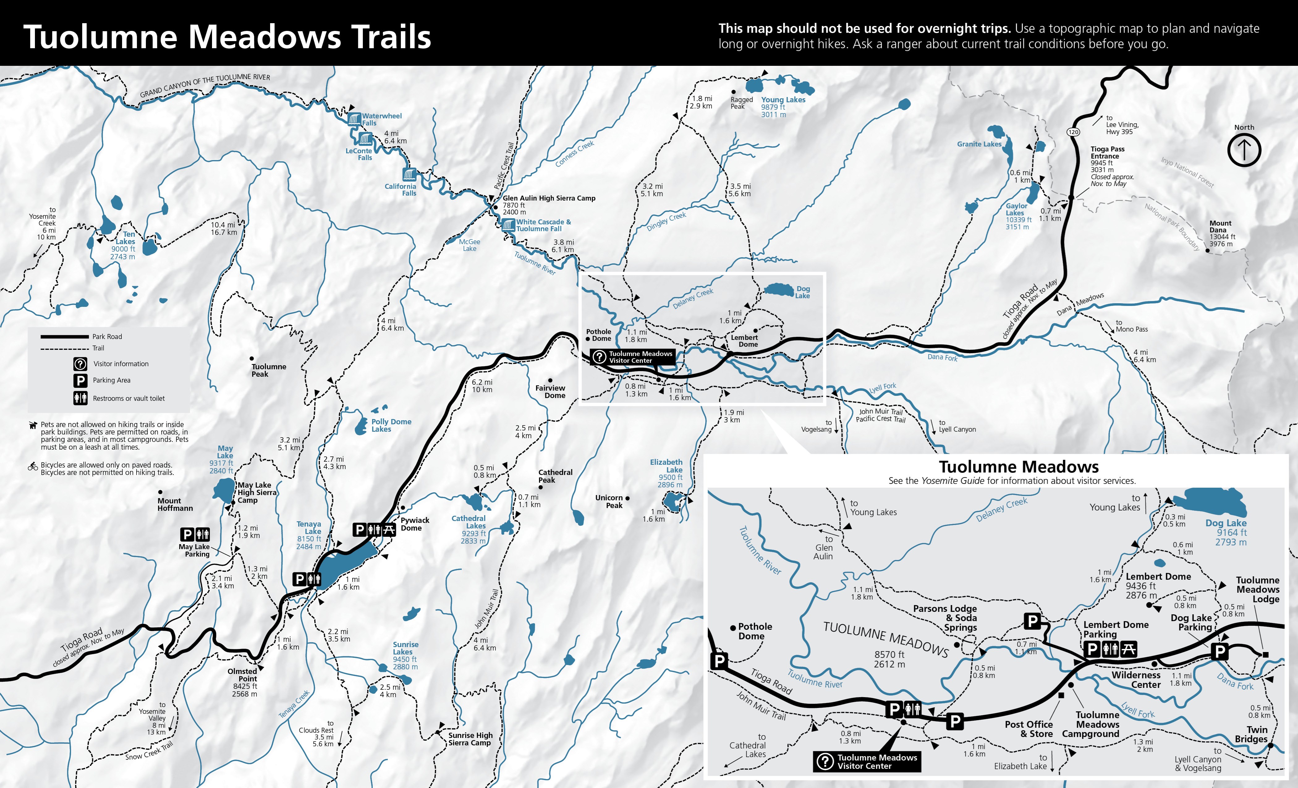
Official dataset route segment

Allowed uses
Hiker/Pedestrian|Pack and Saddle
Distance status
not published at segment level
End coordinate
Latitude
37.7288504
Longitude
-119.573742
Geometry snapshot
Feature id
nps-trail-15283
Path
geometry/v0/snapshots/nps-yose-valley-route-features-20260926.geojson
Sha256
c486dc682fa4984ef8193f095fb4b3545e82910919afeed4e4a735f7cfde7754
Route role
official mainline
Source feature id
15283
Source feature name
Four Mile Trail
Source geometry id
{8A182D23-4D4A-4EFA-86C7-1802A72BBC9F}
Start coordinate
Latitude
37.7330744
Longitude
-119.6011084
Surface
Native
Evidence and sources (1)

No claim effective interval recorded.

Spatial scope IDs: scope-yosemite-valley

  1. Evidence stance: supports · Evidence details

    Reviewed NPS Public Trails features provide official line geometry and exact shared endpoints for Four Mile Trail, Yosemite Falls Trail, the John Muir Trail, and Mist Trail in Yosemite Valley.

    Retrieval time does not establish when an event occurred.

    Observation details · Source details · Original source: National Park Service

    Recorded artifact references
    • geometry/v0/snapshots/nps-yose-valley-route-features-20260926.geojson

    References are not a confirmation of current availability.

Official dataset route segment

Allowed uses
Hiker/Pedestrian|Pack and Saddle
Distance status
not published at segment level
End coordinate
Latitude
37.7597092
Longitude
-119.599108
Geometry snapshot
Feature id
nps-trail-15475
Path
geometry/v0/snapshots/nps-yose-valley-route-features-20260926.geojson
Sha256
c486dc682fa4984ef8193f095fb4b3545e82910919afeed4e4a735f7cfde7754
Route role
official mainline
Source feature id
15475
Source feature name
Yosemite Falls Trail
Source geometry id
{A99D6719-7F56-44C0-BB5A-3CCBC8B2FD0F}
Start coordinate
Latitude
37.7427686
Longitude
-119.603251
Surface
Native
Evidence and sources (1)

No claim effective interval recorded.

Spatial scope IDs: scope-yosemite-valley

  1. Evidence stance: supports · Evidence details

    Reviewed NPS Public Trails features provide official line geometry and exact shared endpoints for Four Mile Trail, Yosemite Falls Trail, the John Muir Trail, and Mist Trail in Yosemite Valley.

    Retrieval time does not establish when an event occurred.

    Observation details · Source details · Original source: National Park Service

    Recorded artifact references
    • geometry/v0/snapshots/nps-yose-valley-route-features-20260926.geojson

    References are not a confirmation of current availability.

Official dataset route segment

Allowed uses
Hiker/Pedestrian
Distance status
not published at segment level
End coordinate
Latitude
37.7311072
Longitude
-119.5583565
Geometry snapshot
Feature id
nps-trail-15622
Path
geometry/v0/snapshots/nps-yose-valley-route-features-20260926.geojson
Sha256
c486dc682fa4984ef8193f095fb4b3545e82910919afeed4e4a735f7cfde7754
Route role
official mainline
Source feature id
15622
Source feature name
John Muir Trail
Source geometry id
{19974261-352D-47F1-8987-2B6B7BD8E469}
Start coordinate
Latitude
37.7318385
Longitude
-119.5581829
Surface
Asphalt
Evidence and sources (1)

No claim effective interval recorded.

Spatial scope IDs: scope-yosemite-valley

  1. Evidence stance: supports · Evidence details

    Reviewed NPS Public Trails features provide official line geometry and exact shared endpoints for Four Mile Trail, Yosemite Falls Trail, the John Muir Trail, and Mist Trail in Yosemite Valley.

    Retrieval time does not establish when an event occurred.

    Observation details · Source details · Original source: National Park Service

    Recorded artifact references
    • geometry/v0/snapshots/nps-yose-valley-route-features-20260926.geojson

    References are not a confirmation of current availability.

Official dataset route segment

Allowed uses
Hiker/Pedestrian|Pack and Saddle
Distance status
not published at segment level
End coordinate
Latitude
37.7330744
Longitude
-119.6011084
Geometry snapshot
Feature id
nps-trail-16033
Path
geometry/v0/snapshots/nps-yose-valley-route-features-20260926.geojson
Sha256
c486dc682fa4984ef8193f095fb4b3545e82910919afeed4e4a735f7cfde7754
Route role
official mainline
Source feature id
16033
Source feature name
Four Mile Trail
Source geometry id
{BA5442ED-E48B-41AF-9598-8362EAB323ED}
Start coordinate
Latitude
37.7338676
Longitude
-119.6018147
Surface
Native
Evidence and sources (1)

No claim effective interval recorded.

Spatial scope IDs: scope-yosemite-valley

  1. Evidence stance: supports · Evidence details

    Reviewed NPS Public Trails features provide official line geometry and exact shared endpoints for Four Mile Trail, Yosemite Falls Trail, the John Muir Trail, and Mist Trail in Yosemite Valley.

    Retrieval time does not establish when an event occurred.

    Observation details · Source details · Original source: National Park Service

    Recorded artifact references
    • geometry/v0/snapshots/nps-yose-valley-route-features-20260926.geojson

    References are not a confirmation of current availability.

Official dataset route segment

Allowed uses
Hiker/Pedestrian|Pack and Saddle
Distance status
not published at segment level
End coordinate
Latitude
37.7225585
Longitude
-119.5348591
Geometry snapshot
Feature id
nps-trail-16205
Path
geometry/v0/snapshots/nps-yose-valley-route-features-20260926.geojson
Sha256
c486dc682fa4984ef8193f095fb4b3545e82910919afeed4e4a735f7cfde7754
Route role
published alternate
Source feature id
16205
Source feature name
John Muir Trail
Source geometry id
{2FEFF223-BFF8-477E-9592-BF3F37977E04}
Start coordinate
Latitude
37.7223488
Longitude
-119.5354711
Surface
Native
Evidence and sources (1)

No claim effective interval recorded.

Spatial scope IDs: scope-yosemite-valley

  1. Evidence stance: supports · Evidence details

    Reviewed NPS Public Trails features provide official line geometry and exact shared endpoints for Four Mile Trail, Yosemite Falls Trail, the John Muir Trail, and Mist Trail in Yosemite Valley.

    Retrieval time does not establish when an event occurred.

    Observation details · Source details · Original source: National Park Service

    Recorded artifact references
    • geometry/v0/snapshots/nps-yose-valley-route-features-20260926.geojson

    References are not a confirmation of current availability.

Official dataset route segment

Allowed uses
Hiker/Pedestrian|Pack and Saddle
Distance status
not published at segment level
End coordinate
Latitude
37.7250241
Longitude
-119.5449369
Geometry snapshot
Feature id
nps-trail-16432
Path
geometry/v0/snapshots/nps-yose-valley-route-features-20260926.geojson
Sha256
c486dc682fa4984ef8193f095fb4b3545e82910919afeed4e4a735f7cfde7754
Route role
published alternate
Source feature id
16432
Source feature name
John Muir Trail
Source geometry id
{E6DD14C3-0C68-49C9-9CEE-588C100584DA}
Start coordinate
Latitude
37.7262171
Longitude
-119.5486602
Surface
Native
Evidence and sources (1)

No claim effective interval recorded.

Spatial scope IDs: scope-yosemite-valley

  1. Evidence stance: supports · Evidence details

    Reviewed NPS Public Trails features provide official line geometry and exact shared endpoints for Four Mile Trail, Yosemite Falls Trail, the John Muir Trail, and Mist Trail in Yosemite Valley.

    Retrieval time does not establish when an event occurred.

    Observation details · Source details · Original source: National Park Service

    Recorded artifact references
    • geometry/v0/snapshots/nps-yose-valley-route-features-20260926.geojson

    References are not a confirmation of current availability.

Official dataset route segment

Allowed uses
Hiker/Pedestrian|Pack and Saddle
Distance status
not published at segment level
End coordinate
Latitude
37.7248429
Longitude
-119.5330322
Geometry snapshot
Feature id
nps-trail-16450
Path
geometry/v0/snapshots/nps-yose-valley-route-features-20260926.geojson
Sha256
c486dc682fa4984ef8193f095fb4b3545e82910919afeed4e4a735f7cfde7754
Route role
published alternate
Source feature id
16450
Source feature name
John Muir Trail
Source geometry id
{2E8199E1-7B41-4250-9ECF-511C544B1B16}
Start coordinate
Latitude
37.7246402
Longitude
-119.5330844
Surface
Native
Evidence and sources (1)

No claim effective interval recorded.

Spatial scope IDs: scope-yosemite-valley

  1. Evidence stance: supports · Evidence details

    Reviewed NPS Public Trails features provide official line geometry and exact shared endpoints for Four Mile Trail, Yosemite Falls Trail, the John Muir Trail, and Mist Trail in Yosemite Valley.

    Retrieval time does not establish when an event occurred.

    Observation details · Source details · Original source: National Park Service

    Recorded artifact references
    • geometry/v0/snapshots/nps-yose-valley-route-features-20260926.geojson

    References are not a confirmation of current availability.

Official dataset route segment

Allowed uses
Hiker/Pedestrian
Distance status
not published at segment level
End coordinate
Latitude
37.7309647
Longitude
-119.5582992
Geometry snapshot
Feature id
nps-trail-16589
Path
geometry/v0/snapshots/nps-yose-valley-route-features-20260926.geojson
Sha256
c486dc682fa4984ef8193f095fb4b3545e82910919afeed4e4a735f7cfde7754
Route role
official mainline
Source feature id
16589
Source feature name
John Muir Trail
Source geometry id
{ACC86EBF-782E-4119-839B-5CC133D46F31}
Start coordinate
Latitude
37.7311072
Longitude
-119.5583565
Surface
Asphalt
Evidence and sources (1)

No claim effective interval recorded.

Spatial scope IDs: scope-yosemite-valley

  1. Evidence stance: supports · Evidence details

    Reviewed NPS Public Trails features provide official line geometry and exact shared endpoints for Four Mile Trail, Yosemite Falls Trail, the John Muir Trail, and Mist Trail in Yosemite Valley.

    Retrieval time does not establish when an event occurred.

    Observation details · Source details · Original source: National Park Service

    Recorded artifact references
    • geometry/v0/snapshots/nps-yose-valley-route-features-20260926.geojson

    References are not a confirmation of current availability.

Official dataset route segment

Allowed uses
Hiker/Pedestrian|Pack and Saddle
Distance status
not published at segment level
End coordinate
Latitude
37.7261811
Longitude
-119.5304051
Geometry snapshot
Feature id
nps-trail-17156
Path
geometry/v0/snapshots/nps-yose-valley-route-features-20260926.geojson
Sha256
c486dc682fa4984ef8193f095fb4b3545e82910919afeed4e4a735f7cfde7754
Route role
published alternate
Source feature id
17156
Source feature name
John Muir Trail
Source geometry id
{78266FAE-7CB7-4E07-9445-F0A57B93F3E8}
Start coordinate
Latitude
37.7248429
Longitude
-119.5330322
Surface
Native
Evidence and sources (1)

No claim effective interval recorded.

Spatial scope IDs: scope-yosemite-valley

  1. Evidence stance: supports · Evidence details

    Reviewed NPS Public Trails features provide official line geometry and exact shared endpoints for Four Mile Trail, Yosemite Falls Trail, the John Muir Trail, and Mist Trail in Yosemite Valley.

    Retrieval time does not establish when an event occurred.

    Observation details · Source details · Original source: National Park Service

    Recorded artifact references
    • geometry/v0/snapshots/nps-yose-valley-route-features-20260926.geojson

    References are not a confirmation of current availability.

Official dataset route segment

Allowed uses
Hiker/Pedestrian
Distance status
not published at segment level
End coordinate
Latitude
37.7261811
Longitude
-119.5304051
Geometry snapshot
Feature id
nps-trail-18748
Path
geometry/v0/snapshots/nps-yose-valley-route-features-20260926.geojson
Sha256
c486dc682fa4984ef8193f095fb4b3545e82910919afeed4e4a735f7cfde7754
Route role
official mainline
Source feature id
18748
Source feature name
Mist Trail
Source geometry id
{DB5A44DC-19E6-4CFD-B6E6-09B62F210E2B}
Start coordinate
Latitude
37.7264676
Longitude
-119.5402726
Surface
Native
Evidence and sources (1)

No claim effective interval recorded.

Spatial scope IDs: scope-yosemite-valley

  1. Evidence stance: supports · Evidence details

    Reviewed NPS Public Trails features provide official line geometry and exact shared endpoints for Four Mile Trail, Yosemite Falls Trail, the John Muir Trail, and Mist Trail in Yosemite Valley.

    Retrieval time does not establish when an event occurred.

    Observation details · Source details · Original source: National Park Service

    Recorded artifact references
    • geometry/v0/snapshots/nps-yose-valley-route-features-20260926.geojson

    References are not a confirmation of current availability.

Official dataset route segment

Allowed uses
Hiker/Pedestrian
Distance status
not published at segment level
End coordinate
Latitude
37.7318385
Longitude
-119.5581829
Geometry snapshot
Feature id
nps-trail-18937
Path
geometry/v0/snapshots/nps-yose-valley-route-features-20260926.geojson
Sha256
c486dc682fa4984ef8193f095fb4b3545e82910919afeed4e4a735f7cfde7754
Route role
official mainline
Source feature id
18937
Source feature name
John Muir Trail
Source geometry id
{5A7E784C-6C06-4F05-8148-027EC7002C1C}
Start coordinate
Latitude
37.7328544
Longitude
-119.5578159
Surface
Asphalt
Evidence and sources (1)

No claim effective interval recorded.

Spatial scope IDs: scope-yosemite-valley

  1. Evidence stance: supports · Evidence details

    Reviewed NPS Public Trails features provide official line geometry and exact shared endpoints for Four Mile Trail, Yosemite Falls Trail, the John Muir Trail, and Mist Trail in Yosemite Valley.

    Retrieval time does not establish when an event occurred.

    Observation details · Source details · Original source: National Park Service

    Recorded artifact references
    • geometry/v0/snapshots/nps-yose-valley-route-features-20260926.geojson

    References are not a confirmation of current availability.

Official dataset route segment

Allowed uses
Hiker/Pedestrian
Distance status
not published at segment level
End coordinate
Latitude
37.7262279
Longitude
-119.5414748
Geometry snapshot
Feature id
nps-trail-19515
Path
geometry/v0/snapshots/nps-yose-valley-route-features-20260926.geojson
Sha256
c486dc682fa4984ef8193f095fb4b3545e82910919afeed4e4a735f7cfde7754
Route role
official mainline
Source feature id
19515
Source feature name
Mist Trail
Source geometry id
{F9F3080A-3780-44C7-90E0-37F569E045D2}
Start coordinate
Latitude
37.7262171
Longitude
-119.5486602
Surface
Native
Evidence and sources (1)

No claim effective interval recorded.

Spatial scope IDs: scope-yosemite-valley

  1. Evidence stance: supports · Evidence details

    Reviewed NPS Public Trails features provide official line geometry and exact shared endpoints for Four Mile Trail, Yosemite Falls Trail, the John Muir Trail, and Mist Trail in Yosemite Valley.

    Retrieval time does not establish when an event occurred.

    Observation details · Source details · Original source: National Park Service

    Recorded artifact references
    • geometry/v0/snapshots/nps-yose-valley-route-features-20260926.geojson

    References are not a confirmation of current availability.

Official dataset route segment

Allowed uses
Hiker/Pedestrian
Distance status
not published at segment level
End coordinate
Latitude
37.726209
Longitude
-119.551714
Geometry snapshot
Feature id
nps-trail-20007
Path
geometry/v0/snapshots/nps-yose-valley-route-features-20260926.geojson
Sha256
c486dc682fa4984ef8193f095fb4b3545e82910919afeed4e4a735f7cfde7754
Route role
official mainline
Source feature id
20007
Source feature name
John Muir Trail
Source geometry id
{01940C75-B42E-4344-B824-79583CE33F09}
Start coordinate
Latitude
37.7309647
Longitude
-119.5582992
Surface
Asphalt
Evidence and sources (1)

No claim effective interval recorded.

Spatial scope IDs: scope-yosemite-valley

  1. Evidence stance: supports · Evidence details

    Reviewed NPS Public Trails features provide official line geometry and exact shared endpoints for Four Mile Trail, Yosemite Falls Trail, the John Muir Trail, and Mist Trail in Yosemite Valley.

    Retrieval time does not establish when an event occurred.

    Observation details · Source details · Original source: National Park Service

    Recorded artifact references
    • geometry/v0/snapshots/nps-yose-valley-route-features-20260926.geojson

    References are not a confirmation of current availability.

Official dataset route segment

Allowed uses
Hiker/Pedestrian
Distance status
not published at segment level
End coordinate
Latitude
37.7259357
Longitude
-119.55152
Geometry snapshot
Feature id
nps-trail-20091
Path
geometry/v0/snapshots/nps-yose-valley-route-features-20260926.geojson
Sha256
c486dc682fa4984ef8193f095fb4b3545e82910919afeed4e4a735f7cfde7754
Route role
official mainline
Source feature id
20091
Source feature name
John Muir Trail
Source geometry id
{B92281CC-C712-49D7-B764-C754D469C49D}
Start coordinate
Latitude
37.726209
Longitude
-119.551714
Surface
Asphalt
Evidence and sources (1)

No claim effective interval recorded.

Spatial scope IDs: scope-yosemite-valley

  1. Evidence stance: supports · Evidence details

    Reviewed NPS Public Trails features provide official line geometry and exact shared endpoints for Four Mile Trail, Yosemite Falls Trail, the John Muir Trail, and Mist Trail in Yosemite Valley.

    Retrieval time does not establish when an event occurred.

    Observation details · Source details · Original source: National Park Service

    Recorded artifact references
    • geometry/v0/snapshots/nps-yose-valley-route-features-20260926.geojson

    References are not a confirmation of current availability.

Official dataset route segment

Allowed uses
Hiker/Pedestrian|Pack and Saddle
Distance status
not published at segment level
End coordinate
Latitude
37.7223488
Longitude
-119.5354711
Geometry snapshot
Feature id
nps-trail-20133
Path
geometry/v0/snapshots/nps-yose-valley-route-features-20260926.geojson
Sha256
c486dc682fa4984ef8193f095fb4b3545e82910919afeed4e4a735f7cfde7754
Route role
published alternate
Source feature id
20133
Source feature name
John Muir Trail
Source geometry id
{0D73CE6B-2DC0-475F-8117-99DB18507E9C}
Start coordinate
Latitude
37.7250241
Longitude
-119.5449369
Surface
Native
Evidence and sources (1)

No claim effective interval recorded.

Spatial scope IDs: scope-yosemite-valley

  1. Evidence stance: supports · Evidence details

    Reviewed NPS Public Trails features provide official line geometry and exact shared endpoints for Four Mile Trail, Yosemite Falls Trail, the John Muir Trail, and Mist Trail in Yosemite Valley.

    Retrieval time does not establish when an event occurred.

    Observation details · Source details · Original source: National Park Service

    Recorded artifact references
    • geometry/v0/snapshots/nps-yose-valley-route-features-20260926.geojson

    References are not a confirmation of current availability.

Official dataset route segment

Allowed uses
Hiker/Pedestrian
Distance status
not published at segment level
End coordinate
Latitude
37.7263468
Longitude
-119.5403774
Geometry snapshot
Feature id
nps-trail-20240
Path
geometry/v0/snapshots/nps-yose-valley-route-features-20260926.geojson
Sha256
c486dc682fa4984ef8193f095fb4b3545e82910919afeed4e4a735f7cfde7754
Route role
official mainline
Source feature id
20240
Source feature name
Mist Trail
Source geometry id
{8BDB7BC9-8687-44C1-BCE7-D58967ADC1A2}
Start coordinate
Latitude
37.7262279
Longitude
-119.5414748
Surface
Native
Evidence and sources (1)

No claim effective interval recorded.

Spatial scope IDs: scope-yosemite-valley

  1. Evidence stance: supports · Evidence details

    Reviewed NPS Public Trails features provide official line geometry and exact shared endpoints for Four Mile Trail, Yosemite Falls Trail, the John Muir Trail, and Mist Trail in Yosemite Valley.

    Retrieval time does not establish when an event occurred.

    Observation details · Source details · Original source: National Park Service

    Recorded artifact references
    • geometry/v0/snapshots/nps-yose-valley-route-features-20260926.geojson

    References are not a confirmation of current availability.

Official dataset route segment

Allowed uses
Hiker/Pedestrian|Pack and Saddle
Distance status
not published at segment level
End coordinate
Latitude
37.7246402
Longitude
-119.5330844
Geometry snapshot
Feature id
nps-trail-21659
Path
geometry/v0/snapshots/nps-yose-valley-route-features-20260926.geojson
Sha256
c486dc682fa4984ef8193f095fb4b3545e82910919afeed4e4a735f7cfde7754
Route role
published alternate
Source feature id
21659
Source feature name
John Muir Trail
Source geometry id
{85C5D551-1B5B-49DD-B310-1A065AABF656}
Start coordinate
Latitude
37.7225585
Longitude
-119.5348591
Surface
Native
Evidence and sources (1)

No claim effective interval recorded.

Spatial scope IDs: scope-yosemite-valley

  1. Evidence stance: supports · Evidence details

    Reviewed NPS Public Trails features provide official line geometry and exact shared endpoints for Four Mile Trail, Yosemite Falls Trail, the John Muir Trail, and Mist Trail in Yosemite Valley.

    Retrieval time does not establish when an event occurred.

    Observation details · Source details · Original source: National Park Service

    Recorded artifact references
    • geometry/v0/snapshots/nps-yose-valley-route-features-20260926.geojson

    References are not a confirmation of current availability.

Official dataset route segment

Allowed uses
Hiker/Pedestrian
Distance status
not published at segment level
End coordinate
Latitude
37.7264676
Longitude
-119.5402726
Geometry snapshot
Feature id
nps-trail-22642
Path
geometry/v0/snapshots/nps-yose-valley-route-features-20260926.geojson
Sha256
c486dc682fa4984ef8193f095fb4b3545e82910919afeed4e4a735f7cfde7754
Route role
official mainline
Source feature id
22642
Source feature name
Mist Trail
Source geometry id
{A4ECB642-9449-4775-B84D-2C086E2465B4}
Start coordinate
Latitude
37.7263468
Longitude
-119.5403774
Surface
Unknown
Evidence and sources (1)

No claim effective interval recorded.

Spatial scope IDs: scope-yosemite-valley

  1. Evidence stance: supports · Evidence details

    Reviewed NPS Public Trails features provide official line geometry and exact shared endpoints for Four Mile Trail, Yosemite Falls Trail, the John Muir Trail, and Mist Trail in Yosemite Valley.

    Retrieval time does not establish when an event occurred.

    Observation details · Source details · Original source: National Park Service

    Recorded artifact references
    • geometry/v0/snapshots/nps-yose-valley-route-features-20260926.geojson

    References are not a confirmation of current availability.

Official dataset route segment

Allowed uses
Hiker/Pedestrian
Distance status
not published at segment level
End coordinate
Latitude
37.5463012
Longitude
-119.6297954
Geometry snapshot
Feature id
nps-trail-15000
Path
geometry/v0/snapshots/nps-yose-wawona-mariposa-route-features-20260926.geojson
Sha256
f89a4338c0a8c7b6c7e10933eb0da4bfdc60ab6034e21d04fc28821cb694f187
Route role
official mainline
Source feature id
15000
Source feature name
Wawona Swinging Bridge Trail
Source geometry id
{EFBF69CC-CA72-4F34-BEC6-789DF8819183}
Start coordinate
Latitude
37.5445757
Longitude
-119.627278
Surface
Unknown
Evidence and sources (1)

No claim effective interval recorded.

Spatial scope IDs: scope-wawona

  1. Evidence stance: supports · Evidence details

    Reviewed NPS Public Trails features identify exact segment endpoints for eight unbranched named Wawona and Mariposa Grove corridors; route membership follows the official trail names already described by NPS route pages. Chilnualna Falls remains excluded because its named dataset features branch and do not establish one mainline.

    Retrieval time does not establish when an event occurred.

    Observation details · Source details · Original source: National Park Service

    Recorded artifact references
    • geometry/v0/snapshots/nps-yose-wawona-mariposa-route-features-20260926.geojson

    References are not a confirmation of current availability.

Official dataset route segment

Allowed uses
Bicycle
Distance status
not published at segment level
End coordinate
Latitude
37.5014171
Longitude
-119.6120187
Geometry snapshot
Feature id
nps-trail-15103
Path
geometry/v0/snapshots/nps-yose-wawona-mariposa-route-features-20260926.geojson
Sha256
f89a4338c0a8c7b6c7e10933eb0da4bfdc60ab6034e21d04fc28821cb694f187
Route role
official mainline
Source feature id
15103
Source feature name
Mariposa Grove Road
Source geometry id
{E9B403E4-F141-48A4-A230-A53A61BD34CD}
Start coordinate
Latitude
37.5071354
Longitude
-119.6308918
Surface
Asphalt
Evidence and sources (1)

No claim effective interval recorded.

Spatial scope IDs: scope-mariposa-grove

  1. Evidence stance: supports · Evidence details

    Reviewed NPS Public Trails features identify exact segment endpoints for eight unbranched named Wawona and Mariposa Grove corridors; route membership follows the official trail names already described by NPS route pages. Chilnualna Falls remains excluded because its named dataset features branch and do not establish one mainline.

    Retrieval time does not establish when an event occurred.

    Observation details · Source details · Original source: National Park Service

    Recorded artifact references
    • geometry/v0/snapshots/nps-yose-wawona-mariposa-route-features-20260926.geojson

    References are not a confirmation of current availability.

Official dataset route segment

Allowed uses
Bicycle
Distance status
not published at segment level
End coordinate
Latitude
37.5021423
Longitude
-119.6027134
Geometry snapshot
Feature id
nps-trail-15148
Path
geometry/v0/snapshots/nps-yose-wawona-mariposa-route-features-20260926.geojson
Sha256
f89a4338c0a8c7b6c7e10933eb0da4bfdc60ab6034e21d04fc28821cb694f187
Route role
official mainline
Source feature id
15148
Source feature name
Mariposa Grove Road
Source geometry id
{FD51F0D9-1FA0-45EE-936C-913DE8AE920E}
Start coordinate
Latitude
37.501565
Longitude
-119.6112599
Surface
Asphalt
Evidence and sources (1)

No claim effective interval recorded.

Spatial scope IDs: scope-mariposa-grove

  1. Evidence stance: supports · Evidence details

    Reviewed NPS Public Trails features identify exact segment endpoints for eight unbranched named Wawona and Mariposa Grove corridors; route membership follows the official trail names already described by NPS route pages. Chilnualna Falls remains excluded because its named dataset features branch and do not establish one mainline.

    Retrieval time does not establish when an event occurred.

    Observation details · Source details · Original source: National Park Service

    Recorded artifact references
    • geometry/v0/snapshots/nps-yose-wawona-mariposa-route-features-20260926.geojson

    References are not a confirmation of current availability.

Official dataset route segment

Allowed uses
Hiker/Pedestrian
Distance status
not published at segment level
End coordinate
Latitude
37.5066632
Longitude
-119.6275798
Geometry snapshot
Feature id
nps-trail-15579
Path
geometry/v0/snapshots/nps-yose-wawona-mariposa-route-features-20260926.geojson
Sha256
f89a4338c0a8c7b6c7e10933eb0da4bfdc60ab6034e21d04fc28821cb694f187
Route role
official mainline
Source feature id
15579
Source feature name
Washburn Trail
Source geometry id
{5D599496-E3B1-416E-AF9E-DCDE94CE1729}
Start coordinate
Latitude
37.4998637
Longitude
-119.6212645
Surface
Native
Evidence and sources (1)

No claim effective interval recorded.

Spatial scope IDs: scope-mariposa-grove

  1. Evidence stance: supports · Evidence details

    Reviewed NPS Public Trails features identify exact segment endpoints for eight unbranched named Wawona and Mariposa Grove corridors; route membership follows the official trail names already described by NPS route pages. Chilnualna Falls remains excluded because its named dataset features branch and do not establish one mainline.

    Retrieval time does not establish when an event occurred.

    Observation details · Source details · Original source: National Park Service

    Recorded artifact references
    • geometry/v0/snapshots/nps-yose-wawona-mariposa-route-features-20260926.geojson

    References are not a confirmation of current availability.

Official dataset route segment

Allowed uses
Hiker/Pedestrian
Distance status
not published at segment level
End coordinate
Latitude
37.5042033
Longitude
-119.6003315
Geometry snapshot
Feature id
nps-trail-16026
Path
geometry/v0/snapshots/nps-yose-wawona-mariposa-route-features-20260926.geojson
Sha256
f89a4338c0a8c7b6c7e10933eb0da4bfdc60ab6034e21d04fc28821cb694f187
Route role
official mainline
Source feature id
16026
Source feature name
Grizzly Giant Loop Trail
Source geometry id
{EF7E7402-CE4E-486F-9327-6E17509EBD23}
Start coordinate
Latitude
37.5036973
Longitude
-119.6009049
Surface
Other
Evidence and sources (1)

No claim effective interval recorded.

Spatial scope IDs: scope-mariposa-grove

  1. Evidence stance: supports · Evidence details

    Reviewed NPS Public Trails features identify exact segment endpoints for eight unbranched named Wawona and Mariposa Grove corridors; route membership follows the official trail names already described by NPS route pages. Chilnualna Falls remains excluded because its named dataset features branch and do not establish one mainline.

    Retrieval time does not establish when an event occurred.

    Observation details · Source details · Original source: National Park Service

    Recorded artifact references
    • geometry/v0/snapshots/nps-yose-wawona-mariposa-route-features-20260926.geojson

    References are not a confirmation of current availability.

Official dataset route segment

Allowed uses
Hiker/Pedestrian
Distance status
not published at segment level
End coordinate
Latitude
37.5128798
Longitude
-119.6008214
Geometry snapshot
Feature id
nps-trail-16226
Path
geometry/v0/snapshots/nps-yose-wawona-mariposa-route-features-20260926.geojson
Sha256
f89a4338c0a8c7b6c7e10933eb0da4bfdc60ab6034e21d04fc28821cb694f187
Route role
official mainline
Source feature id
16226
Source feature name
Guardians of the Grove Loop Trail
Source geometry id
{E4085110-648C-40E0-91E8-B2AA4F406C91}
Start coordinate
Latitude
37.5113276
Longitude
-119.5956758
Surface
Native
Evidence and sources (1)

No claim effective interval recorded.

Spatial scope IDs: scope-mariposa-grove

  1. Evidence stance: supports · Evidence details

    Reviewed NPS Public Trails features identify exact segment endpoints for eight unbranched named Wawona and Mariposa Grove corridors; route membership follows the official trail names already described by NPS route pages. Chilnualna Falls remains excluded because its named dataset features branch and do not establish one mainline.

    Retrieval time does not establish when an event occurred.

    Observation details · Source details · Original source: National Park Service

    Recorded artifact references
    • geometry/v0/snapshots/nps-yose-wawona-mariposa-route-features-20260926.geojson

    References are not a confirmation of current availability.

Official dataset route segment

Allowed uses
Hiker/Pedestrian
Distance status
not published at segment level
End coordinate
Latitude
37.5042033
Longitude
-119.6003315
Geometry snapshot
Feature id
nps-trail-16239
Path
geometry/v0/snapshots/nps-yose-wawona-mariposa-route-features-20260926.geojson
Sha256
f89a4338c0a8c7b6c7e10933eb0da4bfdc60ab6034e21d04fc28821cb694f187
Route role
official mainline
Source feature id
16239
Source feature name
Grizzly Giant Loop Trail
Source geometry id
{E71843FA-2B78-4188-B779-C9B7E8089FA4}
Start coordinate
Latitude
37.5045227
Longitude
-119.6014436
Surface
Asphalt
Evidence and sources (1)

No claim effective interval recorded.

Spatial scope IDs: scope-mariposa-grove

  1. Evidence stance: supports · Evidence details

    Reviewed NPS Public Trails features identify exact segment endpoints for eight unbranched named Wawona and Mariposa Grove corridors; route membership follows the official trail names already described by NPS route pages. Chilnualna Falls remains excluded because its named dataset features branch and do not establish one mainline.

    Retrieval time does not establish when an event occurred.

    Observation details · Source details · Original source: National Park Service

    Recorded artifact references
    • geometry/v0/snapshots/nps-yose-wawona-mariposa-route-features-20260926.geojson

    References are not a confirmation of current availability.

Official dataset route segment

Allowed uses
Bicycle
Distance status
not published at segment level
End coordinate
Latitude
37.5071354
Longitude
-119.6308918
Geometry snapshot
Feature id
nps-trail-16290
Path
geometry/v0/snapshots/nps-yose-wawona-mariposa-route-features-20260926.geojson
Sha256
f89a4338c0a8c7b6c7e10933eb0da4bfdc60ab6034e21d04fc28821cb694f187
Route role
official mainline
Source feature id
16290
Source feature name
Mariposa Grove Road
Source geometry id
{B095DF21-9CB5-43C6-970B-7C161CB32036}
Start coordinate
Latitude
37.5071393
Longitude
-119.6312202
Surface
Asphalt
Evidence and sources (1)

No claim effective interval recorded.

Spatial scope IDs: scope-mariposa-grove

  1. Evidence stance: supports · Evidence details

    Reviewed NPS Public Trails features identify exact segment endpoints for eight unbranched named Wawona and Mariposa Grove corridors; route membership follows the official trail names already described by NPS route pages. Chilnualna Falls remains excluded because its named dataset features branch and do not establish one mainline.

    Retrieval time does not establish when an event occurred.

    Observation details · Source details · Original source: National Park Service

    Recorded artifact references
    • geometry/v0/snapshots/nps-yose-wawona-mariposa-route-features-20260926.geojson

    References are not a confirmation of current availability.

Official dataset route segment

Allowed uses
Hiker/Pedestrian
Distance status
not published at segment level
End coordinate
Latitude
37.5067418
Longitude
-119.6082976
Geometry snapshot
Feature id
nps-trail-16389
Path
geometry/v0/snapshots/nps-yose-wawona-mariposa-route-features-20260926.geojson
Sha256
f89a4338c0a8c7b6c7e10933eb0da4bfdc60ab6034e21d04fc28821cb694f187
Route role
official mainline
Source feature id
16389
Source feature name
Grizzly Giant Loop Trail
Source geometry id
{C47AB6F1-9B8F-4EA3-9E54-2A8F5241E940}
Start coordinate
Latitude
37.5026606
Longitude
-119.6099512
Surface
Native
Evidence and sources (1)

No claim effective interval recorded.

Spatial scope IDs: scope-mariposa-grove

  1. Evidence stance: supports · Evidence details

    Reviewed NPS Public Trails features identify exact segment endpoints for eight unbranched named Wawona and Mariposa Grove corridors; route membership follows the official trail names already described by NPS route pages. Chilnualna Falls remains excluded because its named dataset features branch and do not establish one mainline.

    Retrieval time does not establish when an event occurred.

    Observation details · Source details · Original source: National Park Service

    Recorded artifact references
    • geometry/v0/snapshots/nps-yose-wawona-mariposa-route-features-20260926.geojson

    References are not a confirmation of current availability.

Official dataset route segment

Allowed uses
Hiker/Pedestrian|Pack and Saddle|Bicycle
Distance status
not published at segment level
End coordinate
Latitude
37.5358985
Longitude
-119.656673
Geometry snapshot
Feature id
nps-trail-16611
Path
geometry/v0/snapshots/nps-yose-wawona-mariposa-route-features-20260926.geojson
Sha256
f89a4338c0a8c7b6c7e10933eb0da4bfdc60ab6034e21d04fc28821cb694f187
Route role
official mainline
Source feature id
16611
Source feature name
Wawona Meadow Loop Trail
Source geometry id
{7AA99084-5535-44EA-B786-7C2C28A5794F}
Start coordinate
Latitude
37.5229757
Longitude
-119.6362855
Surface
Native
Evidence and sources (1)

No claim effective interval recorded.

Spatial scope IDs: scope-wawona

  1. Evidence stance: supports · Evidence details

    Reviewed NPS Public Trails features identify exact segment endpoints for eight unbranched named Wawona and Mariposa Grove corridors; route membership follows the official trail names already described by NPS route pages. Chilnualna Falls remains excluded because its named dataset features branch and do not establish one mainline.

    Retrieval time does not establish when an event occurred.

    Observation details · Source details · Original source: National Park Service

    Recorded artifact references
    • geometry/v0/snapshots/nps-yose-wawona-mariposa-route-features-20260926.geojson

    References are not a confirmation of current availability.

Official dataset route segment

Allowed uses
Hiker/Pedestrian|Pack and Saddle|Bicycle
Distance status
not published at segment level
End coordinate
Latitude
37.5231166
Longitude
-119.6361614
Geometry snapshot
Feature id
nps-trail-16770
Path
geometry/v0/snapshots/nps-yose-wawona-mariposa-route-features-20260926.geojson
Sha256
f89a4338c0a8c7b6c7e10933eb0da4bfdc60ab6034e21d04fc28821cb694f187
Route role
official mainline
Source feature id
16770
Source feature name
Wawona Meadow Loop Trail
Source geometry id
{8A8CA2AD-47BD-42E6-9FFF-A414E79A8121}
Start coordinate
Latitude
37.5354409
Longitude
-119.6527474
Surface
Asphalt
Evidence and sources (1)

No claim effective interval recorded.

Spatial scope IDs: scope-wawona

  1. Evidence stance: supports · Evidence details

    Reviewed NPS Public Trails features identify exact segment endpoints for eight unbranched named Wawona and Mariposa Grove corridors; route membership follows the official trail names already described by NPS route pages. Chilnualna Falls remains excluded because its named dataset features branch and do not establish one mainline.

    Retrieval time does not establish when an event occurred.

    Observation details · Source details · Original source: National Park Service

    Recorded artifact references
    • geometry/v0/snapshots/nps-yose-wawona-mariposa-route-features-20260926.geojson

    References are not a confirmation of current availability.

Official dataset route segment

Allowed uses
Hiker/Pedestrian
Distance status
not published at segment level
End coordinate
Latitude
37.5229757
Longitude
-119.6362855
Geometry snapshot
Feature id
nps-trail-16837
Path
geometry/v0/snapshots/nps-yose-wawona-mariposa-route-features-20260926.geojson
Sha256
f89a4338c0a8c7b6c7e10933eb0da4bfdc60ab6034e21d04fc28821cb694f187
Route role
official mainline
Source feature id
16837
Source feature name
Wawona Meadow Loop Trail
Source geometry id
{B9FEBED4-1483-4372-A78A-C4D036CE1E6A}
Start coordinate
Latitude
37.5231166
Longitude
-119.6361614
Surface
Unknown
Evidence and sources (1)

No claim effective interval recorded.

Spatial scope IDs: scope-wawona

  1. Evidence stance: supports · Evidence details

    Reviewed NPS Public Trails features identify exact segment endpoints for eight unbranched named Wawona and Mariposa Grove corridors; route membership follows the official trail names already described by NPS route pages. Chilnualna Falls remains excluded because its named dataset features branch and do not establish one mainline.

    Retrieval time does not establish when an event occurred.

    Observation details · Source details · Original source: National Park Service

    Recorded artifact references
    • geometry/v0/snapshots/nps-yose-wawona-mariposa-route-features-20260926.geojson

    References are not a confirmation of current availability.

Official dataset route segment

Allowed uses
Hiker/Pedestrian
Distance status
not published at segment level
End coordinate
Latitude
37.5149824
Longitude
-119.5948219
Geometry snapshot
Feature id
nps-trail-17198
Path
geometry/v0/snapshots/nps-yose-wawona-mariposa-route-features-20260926.geojson
Sha256
f89a4338c0a8c7b6c7e10933eb0da4bfdc60ab6034e21d04fc28821cb694f187
Route role
official mainline
Source feature id
17198
Source feature name
Guardians of the Grove Loop Trail
Source geometry id
{4A418740-8B6D-40D1-8CDF-FD0F50821216}
Start coordinate
Latitude
37.5113782
Longitude
-119.5954127
Surface
Native
Evidence and sources (1)

No claim effective interval recorded.

Spatial scope IDs: scope-mariposa-grove

  1. Evidence stance: supports · Evidence details

    Reviewed NPS Public Trails features identify exact segment endpoints for eight unbranched named Wawona and Mariposa Grove corridors; route membership follows the official trail names already described by NPS route pages. Chilnualna Falls remains excluded because its named dataset features branch and do not establish one mainline.

    Retrieval time does not establish when an event occurred.

    Observation details · Source details · Original source: National Park Service

    Recorded artifact references
    • geometry/v0/snapshots/nps-yose-wawona-mariposa-route-features-20260926.geojson

    References are not a confirmation of current availability.

Official dataset route segment

Allowed uses
Hiker/Pedestrian
Distance status
not published at segment level
End coordinate
Latitude
37.5045227
Longitude
-119.6014436
Geometry snapshot
Feature id
nps-trail-17265
Path
geometry/v0/snapshots/nps-yose-wawona-mariposa-route-features-20260926.geojson
Sha256
f89a4338c0a8c7b6c7e10933eb0da4bfdc60ab6034e21d04fc28821cb694f187
Route role
official mainline
Source feature id
17265
Source feature name
Grizzly Giant Loop Trail
Source geometry id
{E64E1344-C6FA-4338-B1D4-9C004C338F1E}
Start coordinate
Latitude
37.5067418
Longitude
-119.6082976
Surface
Native
Evidence and sources (1)

No claim effective interval recorded.

Spatial scope IDs: scope-mariposa-grove

  1. Evidence stance: supports · Evidence details

    Reviewed NPS Public Trails features identify exact segment endpoints for eight unbranched named Wawona and Mariposa Grove corridors; route membership follows the official trail names already described by NPS route pages. Chilnualna Falls remains excluded because its named dataset features branch and do not establish one mainline.

    Retrieval time does not establish when an event occurred.

    Observation details · Source details · Original source: National Park Service

    Recorded artifact references
    • geometry/v0/snapshots/nps-yose-wawona-mariposa-route-features-20260926.geojson

    References are not a confirmation of current availability.

Official dataset route segment

Allowed uses
Bicycle
Distance status
not published at segment level
End coordinate
Latitude
37.5014679
Longitude
-119.6112719
Geometry snapshot
Feature id
nps-trail-17380
Path
geometry/v0/snapshots/nps-yose-wawona-mariposa-route-features-20260926.geojson
Sha256
f89a4338c0a8c7b6c7e10933eb0da4bfdc60ab6034e21d04fc28821cb694f187
Route role
official mainline
Source feature id
17380
Source feature name
Mariposa Grove Road
Source geometry id
{B8501E6A-CC1F-4BD1-BD9C-14CA6208C1E5}
Start coordinate
Latitude
37.5014171
Longitude
-119.6120187
Surface
Asphalt
Evidence and sources (1)

No claim effective interval recorded.

Spatial scope IDs: scope-mariposa-grove

  1. Evidence stance: supports · Evidence details

    Reviewed NPS Public Trails features identify exact segment endpoints for eight unbranched named Wawona and Mariposa Grove corridors; route membership follows the official trail names already described by NPS route pages. Chilnualna Falls remains excluded because its named dataset features branch and do not establish one mainline.

    Retrieval time does not establish when an event occurred.

    Observation details · Source details · Original source: National Park Service

    Recorded artifact references
    • geometry/v0/snapshots/nps-yose-wawona-mariposa-route-features-20260926.geojson

    References are not a confirmation of current availability.

Official dataset route segment

Allowed uses
Hiker/Pedestrian
Distance status
not published at segment level
End coordinate
Latitude
37.5144907
Longitude
-119.5995233
Geometry snapshot
Feature id
nps-trail-17942
Path
geometry/v0/snapshots/nps-yose-wawona-mariposa-route-features-20260926.geojson
Sha256
f89a4338c0a8c7b6c7e10933eb0da4bfdc60ab6034e21d04fc28821cb694f187
Route role
official mainline
Source feature id
17942
Source feature name
Guardians of the Grove Loop Trail
Source geometry id
{CCC72982-4175-4D59-99BF-2C74652B2EBF}
Start coordinate
Latitude
37.5137313
Longitude
-119.5988707
Surface
Native
Evidence and sources (1)

No claim effective interval recorded.

Spatial scope IDs: scope-mariposa-grove

  1. Evidence stance: supports · Evidence details

    Reviewed NPS Public Trails features identify exact segment endpoints for eight unbranched named Wawona and Mariposa Grove corridors; route membership follows the official trail names already described by NPS route pages. Chilnualna Falls remains excluded because its named dataset features branch and do not establish one mainline.

    Retrieval time does not establish when an event occurred.

    Observation details · Source details · Original source: National Park Service

    Recorded artifact references
    • geometry/v0/snapshots/nps-yose-wawona-mariposa-route-features-20260926.geojson

    References are not a confirmation of current availability.

Official dataset route segment

Allowed uses
Hiker/Pedestrian
Distance status
not published at segment level
End coordinate
Latitude
37.5024888
Longitude
-119.6098484
Geometry snapshot
Feature id
nps-trail-18212
Path
geometry/v0/snapshots/nps-yose-wawona-mariposa-route-features-20260926.geojson
Sha256
f89a4338c0a8c7b6c7e10933eb0da4bfdc60ab6034e21d04fc28821cb694f187
Route role
official mainline
Source feature id
18212
Source feature name
Big Trees Loop Trail
Source geometry id
{7628712B-AE58-495A-A319-FEFFDC2DDCB5}
Start coordinate
Latitude
37.5015851
Longitude
-119.6110176
Surface
Asphalt
Evidence and sources (1)

No claim effective interval recorded.

Spatial scope IDs: scope-mariposa-grove

  1. Evidence stance: supports · Evidence details

    Reviewed NPS Public Trails features identify exact segment endpoints for eight unbranched named Wawona and Mariposa Grove corridors; route membership follows the official trail names already described by NPS route pages. Chilnualna Falls remains excluded because its named dataset features branch and do not establish one mainline.

    Retrieval time does not establish when an event occurred.

    Observation details · Source details · Original source: National Park Service

    Recorded artifact references
    • geometry/v0/snapshots/nps-yose-wawona-mariposa-route-features-20260926.geojson

    References are not a confirmation of current availability.

Official dataset route segment

Allowed uses
Hiker/Pedestrian
Distance status
not published at segment level
End coordinate
Latitude
37.5026606
Longitude
-119.6099512
Geometry snapshot
Feature id
nps-trail-18351
Path
geometry/v0/snapshots/nps-yose-wawona-mariposa-route-features-20260926.geojson
Sha256
f89a4338c0a8c7b6c7e10933eb0da4bfdc60ab6034e21d04fc28821cb694f187
Route role
official mainline
Source feature id
18351
Source feature name
Grizzly Giant Loop Trail
Source geometry id
{C6FFE196-0965-4B2F-BD26-6819B0270F4A}
Start coordinate
Latitude
37.5024888
Longitude
-119.6098484
Surface
Asphalt
Evidence and sources (1)

No claim effective interval recorded.

Spatial scope IDs: scope-mariposa-grove

  1. Evidence stance: supports · Evidence details

    Reviewed NPS Public Trails features identify exact segment endpoints for eight unbranched named Wawona and Mariposa Grove corridors; route membership follows the official trail names already described by NPS route pages. Chilnualna Falls remains excluded because its named dataset features branch and do not establish one mainline.

    Retrieval time does not establish when an event occurred.

    Observation details · Source details · Original source: National Park Service

    Recorded artifact references
    • geometry/v0/snapshots/nps-yose-wawona-mariposa-route-features-20260926.geojson

    References are not a confirmation of current availability.

Official dataset route segment

Allowed uses
Hiker/Pedestrian
Distance status
not published at segment level
End coordinate
Latitude
37.5025557
Longitude
-119.6088674
Geometry snapshot
Feature id
nps-trail-18911
Path
geometry/v0/snapshots/nps-yose-wawona-mariposa-route-features-20260926.geojson
Sha256
f89a4338c0a8c7b6c7e10933eb0da4bfdc60ab6034e21d04fc28821cb694f187
Route role
official mainline
Source feature id
18911
Source feature name
Big Trees Loop Trail
Source geometry id
{651B94ED-956D-4764-A484-58075DF6D17A}
Start coordinate
Latitude
37.502731
Longitude
-119.609013
Surface
Asphalt
Evidence and sources (1)

No claim effective interval recorded.

Spatial scope IDs: scope-mariposa-grove

  1. Evidence stance: supports · Evidence details

    Reviewed NPS Public Trails features identify exact segment endpoints for eight unbranched named Wawona and Mariposa Grove corridors; route membership follows the official trail names already described by NPS route pages. Chilnualna Falls remains excluded because its named dataset features branch and do not establish one mainline.

    Retrieval time does not establish when an event occurred.

    Observation details · Source details · Original source: National Park Service

    Recorded artifact references
    • geometry/v0/snapshots/nps-yose-wawona-mariposa-route-features-20260926.geojson

    References are not a confirmation of current availability.

Official dataset route segment

Allowed uses
Hiker/Pedestrian
Distance status
not published at segment level
End coordinate
Latitude
37.5161126
Longitude
-119.5949239
Geometry snapshot
Feature id
nps-trail-18921
Path
geometry/v0/snapshots/nps-yose-wawona-mariposa-route-features-20260926.geojson
Sha256
f89a4338c0a8c7b6c7e10933eb0da4bfdc60ab6034e21d04fc28821cb694f187
Route role
official mainline
Source feature id
18921
Source feature name
Guardians of the Grove Loop Trail
Source geometry id
{85873B32-4533-41C1-8508-37B20DD66E23}
Start coordinate
Latitude
37.5149824
Longitude
-119.5948219
Surface
Native
Evidence and sources (1)

No claim effective interval recorded.

Spatial scope IDs: scope-mariposa-grove

  1. Evidence stance: supports · Evidence details

    Reviewed NPS Public Trails features identify exact segment endpoints for eight unbranched named Wawona and Mariposa Grove corridors; route membership follows the official trail names already described by NPS route pages. Chilnualna Falls remains excluded because its named dataset features branch and do not establish one mainline.

    Retrieval time does not establish when an event occurred.

    Observation details · Source details · Original source: National Park Service

    Recorded artifact references
    • geometry/v0/snapshots/nps-yose-wawona-mariposa-route-features-20260926.geojson

    References are not a confirmation of current availability.

Official dataset route segment

Allowed uses
Hiker/Pedestrian
Distance status
not published at segment level
End coordinate
Latitude
37.4998637
Longitude
-119.6212645
Geometry snapshot
Feature id
nps-trail-19395
Path
geometry/v0/snapshots/nps-yose-wawona-mariposa-route-features-20260926.geojson
Sha256
f89a4338c0a8c7b6c7e10933eb0da4bfdc60ab6034e21d04fc28821cb694f187
Route role
official mainline
Source feature id
19395
Source feature name
Washburn Trail
Source geometry id
{90F5017E-2DE2-4689-BCC6-C3C37B2D7270}
Start coordinate
Latitude
37.5012884
Longitude
-119.6106709
Surface
Native
Evidence and sources (1)

No claim effective interval recorded.

Spatial scope IDs: scope-mariposa-grove

  1. Evidence stance: supports · Evidence details

    Reviewed NPS Public Trails features identify exact segment endpoints for eight unbranched named Wawona and Mariposa Grove corridors; route membership follows the official trail names already described by NPS route pages. Chilnualna Falls remains excluded because its named dataset features branch and do not establish one mainline.

    Retrieval time does not establish when an event occurred.

    Observation details · Source details · Original source: National Park Service

    Recorded artifact references
    • geometry/v0/snapshots/nps-yose-wawona-mariposa-route-features-20260926.geojson

    References are not a confirmation of current availability.

Official dataset route segment

Allowed uses
Hiker/Pedestrian
Distance status
not published at segment level
End coordinate
Latitude
37.5133311
Longitude
-119.5984313
Geometry snapshot
Feature id
nps-trail-19890
Path
geometry/v0/snapshots/nps-yose-wawona-mariposa-route-features-20260926.geojson
Sha256
f89a4338c0a8c7b6c7e10933eb0da4bfdc60ab6034e21d04fc28821cb694f187
Route role
official mainline
Source feature id
19890
Source feature name
Guardians of the Grove Loop Trail
Source geometry id
{E8968729-7377-4D0E-A117-EDBCE664716D}
Start coordinate
Latitude
37.5130774
Longitude
-119.6003703
Surface
Native
Evidence and sources (1)

No claim effective interval recorded.

Spatial scope IDs: scope-mariposa-grove

  1. Evidence stance: supports · Evidence details

    Reviewed NPS Public Trails features identify exact segment endpoints for eight unbranched named Wawona and Mariposa Grove corridors; route membership follows the official trail names already described by NPS route pages. Chilnualna Falls remains excluded because its named dataset features branch and do not establish one mainline.

    Retrieval time does not establish when an event occurred.

    Observation details · Source details · Original source: National Park Service

    Recorded artifact references
    • geometry/v0/snapshots/nps-yose-wawona-mariposa-route-features-20260926.geojson

    References are not a confirmation of current availability.

Official dataset route segment

Allowed uses
Hiker/Pedestrian
Distance status
not published at segment level
End coordinate
Latitude
37.5427549
Longitude
-119.6560079
Geometry snapshot
Feature id
nps-trail-20409
Path
geometry/v0/snapshots/nps-yose-wawona-mariposa-route-features-20260926.geojson
Sha256
f89a4338c0a8c7b6c7e10933eb0da4bfdc60ab6034e21d04fc28821cb694f187
Route role
official mainline
Source feature id
20409
Source feature name
Alder Creek Trail
Source geometry id
{4A29215C-483F-4CD6-B9F0-917D11E318E5}
Start coordinate
Latitude
37.5680816
Longitude
-119.6818346
Surface
Unknown
Evidence and sources (1)

No claim effective interval recorded.

Spatial scope IDs: scope-wawona

  1. Evidence stance: supports · Evidence details

    Reviewed NPS Public Trails features identify exact segment endpoints for eight unbranched named Wawona and Mariposa Grove corridors; route membership follows the official trail names already described by NPS route pages. Chilnualna Falls remains excluded because its named dataset features branch and do not establish one mainline.

    Retrieval time does not establish when an event occurred.

    Observation details · Source details · Original source: National Park Service

    Recorded artifact references
    • geometry/v0/snapshots/nps-yose-wawona-mariposa-route-features-20260926.geojson

    References are not a confirmation of current availability.

Official dataset route segment

Allowed uses
Hiker/Pedestrian
Distance status
not published at segment level
End coordinate
Latitude
37.5113276
Longitude
-119.5956758
Geometry snapshot
Feature id
nps-trail-20654
Path
geometry/v0/snapshots/nps-yose-wawona-mariposa-route-features-20260926.geojson
Sha256
f89a4338c0a8c7b6c7e10933eb0da4bfdc60ab6034e21d04fc28821cb694f187
Route role
official mainline
Source feature id
20654
Source feature name
Guardians of the Grove Loop Trail
Source geometry id
{2CE50E90-0803-4B70-9865-E01269F236AF}
Start coordinate
Latitude
37.5113782
Longitude
-119.5954127
Surface
Native
Evidence and sources (1)

No claim effective interval recorded.

Spatial scope IDs: scope-mariposa-grove

  1. Evidence stance: supports · Evidence details

    Reviewed NPS Public Trails features identify exact segment endpoints for eight unbranched named Wawona and Mariposa Grove corridors; route membership follows the official trail names already described by NPS route pages. Chilnualna Falls remains excluded because its named dataset features branch and do not establish one mainline.

    Retrieval time does not establish when an event occurred.

    Observation details · Source details · Original source: National Park Service

    Recorded artifact references
    • geometry/v0/snapshots/nps-yose-wawona-mariposa-route-features-20260926.geojson

    References are not a confirmation of current availability.

Official dataset route segment

Allowed uses
Hiker/Pedestrian
Distance status
not published at segment level
End coordinate
Latitude
37.5028008
Longitude
-119.6092414
Geometry snapshot
Feature id
nps-trail-21647
Path
geometry/v0/snapshots/nps-yose-wawona-mariposa-route-features-20260926.geojson
Sha256
f89a4338c0a8c7b6c7e10933eb0da4bfdc60ab6034e21d04fc28821cb694f187
Route role
official mainline
Source feature id
21647
Source feature name
Big Trees Loop Trail
Source geometry id
{A356D44C-0FDC-4FAF-97CD-E38B6A0C006A}
Start coordinate
Latitude
37.5024888
Longitude
-119.6098484
Surface
Asphalt
Evidence and sources (1)

No claim effective interval recorded.

Spatial scope IDs: scope-mariposa-grove

  1. Evidence stance: supports · Evidence details

    Reviewed NPS Public Trails features identify exact segment endpoints for eight unbranched named Wawona and Mariposa Grove corridors; route membership follows the official trail names already described by NPS route pages. Chilnualna Falls remains excluded because its named dataset features branch and do not establish one mainline.

    Retrieval time does not establish when an event occurred.

    Observation details · Source details · Original source: National Park Service

    Recorded artifact references
    • geometry/v0/snapshots/nps-yose-wawona-mariposa-route-features-20260926.geojson

    References are not a confirmation of current availability.

Official dataset route segment

Allowed uses
Hiker/Pedestrian
Distance status
not published at segment level
End coordinate
Latitude
37.5130774
Longitude
-119.6003703
Geometry snapshot
Feature id
nps-trail-21664
Path
geometry/v0/snapshots/nps-yose-wawona-mariposa-route-features-20260926.geojson
Sha256
f89a4338c0a8c7b6c7e10933eb0da4bfdc60ab6034e21d04fc28821cb694f187
Route role
official mainline
Source feature id
21664
Source feature name
Guardians of the Grove Loop Trail
Source geometry id
{0259016A-B6FD-47C5-94C8-718ADE440C50}
Start coordinate
Latitude
37.5128798
Longitude
-119.6008214
Surface
Native
Evidence and sources (1)

No claim effective interval recorded.

Spatial scope IDs: scope-mariposa-grove

  1. Evidence stance: supports · Evidence details

    Reviewed NPS Public Trails features identify exact segment endpoints for eight unbranched named Wawona and Mariposa Grove corridors; route membership follows the official trail names already described by NPS route pages. Chilnualna Falls remains excluded because its named dataset features branch and do not establish one mainline.

    Retrieval time does not establish when an event occurred.

    Observation details · Source details · Original source: National Park Service

    Recorded artifact references
    • geometry/v0/snapshots/nps-yose-wawona-mariposa-route-features-20260926.geojson

    References are not a confirmation of current availability.

Official dataset route segment

Allowed uses
Hiker/Pedestrian
Distance status
not published at segment level
End coordinate
Latitude
37.5137313
Longitude
-119.5988707
Geometry snapshot
Feature id
nps-trail-21874
Path
geometry/v0/snapshots/nps-yose-wawona-mariposa-route-features-20260926.geojson
Sha256
f89a4338c0a8c7b6c7e10933eb0da4bfdc60ab6034e21d04fc28821cb694f187
Route role
official mainline
Source feature id
21874
Source feature name
Guardians of the Grove Loop Trail
Source geometry id
{EA505378-FFE2-4577-9DFF-FF5586DD67BD}
Start coordinate
Latitude
37.5133311
Longitude
-119.5984313
Surface
Native
Evidence and sources (1)

No claim effective interval recorded.

Spatial scope IDs: scope-mariposa-grove

  1. Evidence stance: supports · Evidence details

    Reviewed NPS Public Trails features identify exact segment endpoints for eight unbranched named Wawona and Mariposa Grove corridors; route membership follows the official trail names already described by NPS route pages. Chilnualna Falls remains excluded because its named dataset features branch and do not establish one mainline.

    Retrieval time does not establish when an event occurred.

    Observation details · Source details · Original source: National Park Service

    Recorded artifact references
    • geometry/v0/snapshots/nps-yose-wawona-mariposa-route-features-20260926.geojson

    References are not a confirmation of current availability.

Official dataset route segment

Allowed uses
Hiker/Pedestrian
Distance status
not published at segment level
End coordinate
Latitude
37.502731
Longitude
-119.609013
Geometry snapshot
Feature id
nps-trail-21961
Path
geometry/v0/snapshots/nps-yose-wawona-mariposa-route-features-20260926.geojson
Sha256
f89a4338c0a8c7b6c7e10933eb0da4bfdc60ab6034e21d04fc28821cb694f187
Route role
official mainline
Source feature id
21961
Source feature name
Big Trees Loop Trail
Source geometry id
{B0EB34EC-2933-4B83-AE40-8A647EE285AC}
Start coordinate
Latitude
37.5028008
Longitude
-119.6092414
Surface
Wood
Evidence and sources (1)

No claim effective interval recorded.

Spatial scope IDs: scope-mariposa-grove

  1. Evidence stance: supports · Evidence details

    Reviewed NPS Public Trails features identify exact segment endpoints for eight unbranched named Wawona and Mariposa Grove corridors; route membership follows the official trail names already described by NPS route pages. Chilnualna Falls remains excluded because its named dataset features branch and do not establish one mainline.

    Retrieval time does not establish when an event occurred.

    Observation details · Source details · Original source: National Park Service

    Recorded artifact references
    • geometry/v0/snapshots/nps-yose-wawona-mariposa-route-features-20260926.geojson

    References are not a confirmation of current availability.

Official dataset route segment

Allowed uses
Bicycle
Distance status
not published at segment level
End coordinate
Latitude
37.501565
Longitude
-119.6112599
Geometry snapshot
Feature id
nps-trail-22364
Path
geometry/v0/snapshots/nps-yose-wawona-mariposa-route-features-20260926.geojson
Sha256
f89a4338c0a8c7b6c7e10933eb0da4bfdc60ab6034e21d04fc28821cb694f187
Route role
official mainline
Source feature id
22364
Source feature name
Mariposa Grove Road
Source geometry id
{3430F0E6-A77D-4120-A7EF-E4E172D079F6}
Start coordinate
Latitude
37.5014679
Longitude
-119.6112719
Surface
Asphalt
Evidence and sources (1)

No claim effective interval recorded.

Spatial scope IDs: scope-mariposa-grove

  1. Evidence stance: supports · Evidence details

    Reviewed NPS Public Trails features identify exact segment endpoints for eight unbranched named Wawona and Mariposa Grove corridors; route membership follows the official trail names already described by NPS route pages. Chilnualna Falls remains excluded because its named dataset features branch and do not establish one mainline.

    Retrieval time does not establish when an event occurred.

    Observation details · Source details · Original source: National Park Service

    Recorded artifact references
    • geometry/v0/snapshots/nps-yose-wawona-mariposa-route-features-20260926.geojson

    References are not a confirmation of current availability.

Official dataset route segment

Allowed uses
Hiker/Pedestrian
Distance status
not published at segment level
End coordinate
Latitude
37.5430732
Longitude
-119.6276915
Geometry snapshot
Feature id
nps-trail-22788
Path
geometry/v0/snapshots/nps-yose-wawona-mariposa-route-features-20260926.geojson
Sha256
f89a4338c0a8c7b6c7e10933eb0da4bfdc60ab6034e21d04fc28821cb694f187
Route role
official mainline
Source feature id
22788
Source feature name
Wawona Swinging Bridge Trail
Source geometry id
{3DB00918-3E19-44C5-BC86-C8FB069071B1}
Start coordinate
Latitude
37.5445757
Longitude
-119.627278
Surface
Unknown
Evidence and sources (1)

No claim effective interval recorded.

Spatial scope IDs: scope-wawona

  1. Evidence stance: supports · Evidence details

    Reviewed NPS Public Trails features identify exact segment endpoints for eight unbranched named Wawona and Mariposa Grove corridors; route membership follows the official trail names already described by NPS route pages. Chilnualna Falls remains excluded because its named dataset features branch and do not establish one mainline.

    Retrieval time does not establish when an event occurred.

    Observation details · Source details · Original source: National Park Service

    Recorded artifact references
    • geometry/v0/snapshots/nps-yose-wawona-mariposa-route-features-20260926.geojson

    References are not a confirmation of current availability.

Official dataset route segment

Allowed uses
Hiker/Pedestrian|Pack and Saddle
Distance status
published at route level only
End coordinate
Latitude
37.8505206
Longitude
-119.6152103
Geometry snapshot
Feature id
nps-trail-18552
Path
geometry/v0/snapshots/nps-yose-west-tioga-route-features-20260926.geojson
Sha256
e9b878b1da456178657f8d751e67b836c82b6e31ec65d00e570f154b933cb03e
Route role
official mainline
Source feature id
18552
Source feature name
Lukens Lake Trail
Source geometry id
{34D335E6-B385-4E93-A9A4-522019F96F87}
Start coordinate
Latitude
37.8654271
Longitude
-119.6216945
Surface
Native
Xy accuracy
unknown
Evidence and sources (1)

No claim effective interval recorded.

Spatial scope IDs: scope-tioga-road-corridor

  1. Evidence stance: supports · Evidence details

    Reviewed NPS Public Trails features identify the complete named May Lake Trail and Lukens Lake Trail geometries selected against the official NPS day-hike descriptions.

    Retrieval time does not establish when an event occurred.

    Observation details · Source details · Original source: National Park Service

    Recorded artifact references
    • geometry/v0/snapshots/nps-yose-west-tioga-route-features-20260926.geojson

    References are not a confirmation of current availability.

Official dataset route segment

Allowed uses
Hiker/Pedestrian|Pack and Saddle
Distance status
published at route level only
End coordinate
Latitude
37.8441673
Longitude
-119.4910489
Geometry snapshot
Feature id
nps-trail-19452
Path
geometry/v0/snapshots/nps-yose-west-tioga-route-features-20260926.geojson
Sha256
e9b878b1da456178657f8d751e67b836c82b6e31ec65d00e570f154b933cb03e
Route role
official mainline
Source feature id
19452
Source feature name
May Lake Trail
Source geometry id
{C7AE7A2A-58C2-4734-B11F-0BECAE529FA7}
Start coordinate
Latitude
37.8325331
Longitude
-119.4910966
Surface
Native
Xy accuracy
unknown
Evidence and sources (1)

No claim effective interval recorded.

Spatial scope IDs: scope-tioga-road-corridor

  1. Evidence stance: supports · Evidence details

    Reviewed NPS Public Trails features identify the complete named May Lake Trail and Lukens Lake Trail geometries selected against the official NPS day-hike descriptions.

    Retrieval time does not establish when an event occurred.

    Observation details · Source details · Original source: National Park Service

    Recorded artifact references
    • geometry/v0/snapshots/nps-yose-west-tioga-route-features-20260926.geojson

    References are not a confirmation of current availability.

Recorded observations

Browse observations separately (7)

The NPS Public Trails FeatureServer returned one exact endpoint-matched public trail LineString for each of the three already-published Cinder Cone summit approach segments. All three are identified as existing trails. Mapping method, map source, source date, and XY accuracy are unknown for these features; the geometry is planning evidence and is not represented as navigation-grade.

Retrieval time does not establish when an event occurred.

Observation details · Source details · Original source: National Park Service

Recorded artifact references
  • geometry/v0/snapshots/nps-lavo-cinder-cone-approach-20260923.geojson
  • sha256:50d218a1cec59453ce4e12aa84a9a0f9768914c10faa715e307b32db764c4b6a

References are not a confirmation of current availability.

Reviewed NPS Public Trails features provide exact shared endpoints for the Sentinel Dome, Taft Point, and McGurk Meadow paths selected against the official Glacier Point Road trail map.

Retrieval time does not establish when an event occurred.

Observation details · Source details · Original source: National Park Service

Recorded artifact references
  • geometry/v0/snapshots/nps-yose-glacier-point-route-features-20260926.geojson

References are not a confirmation of current availability.

Reviewed NPS Public Trails features provide exact shared endpoints for the Wapama Falls shoreline chain and Poopenaut Valley Trail selected against the official Hetch Hetchy map.

Retrieval time does not establish when an event occurred.

Observation details · Source details · Original source: National Park Service

Recorded artifact references
  • geometry/v0/snapshots/nps-yose-hetch-hetchy-route-features-20260926.geojson

References are not a confirmation of current availability.

Reviewed NPS Public Trails features provide the displayed line geometry and source feature identifiers for nine Tuolumne day-hike graphs selected against the official map.

Retrieval time does not establish when an event occurred.

Observation details · Source details · Original source: National Park Service

Recorded artifact references
  • geometry/v0/snapshots/nps-yose-tuolumne-route-features-20260925.geojson

References are not a confirmation of current availability.

Reviewed NPS Public Trails features identify exact segment endpoints for eight unbranched named Wawona and Mariposa Grove corridors; route membership follows the official trail names already described by NPS route pages. Chilnualna Falls remains excluded because its named dataset features branch and do not establish one mainline.

Retrieval time does not establish when an event occurred.

Observation details · Source details · Original source: National Park Service

Recorded artifact references
  • geometry/v0/snapshots/nps-yose-wawona-mariposa-route-features-20260926.geojson

References are not a confirmation of current availability.

Reviewed NPS Public Trails features identify the complete named May Lake Trail and Lukens Lake Trail geometries selected against the official NPS day-hike descriptions.

Retrieval time does not establish when an event occurred.

Observation details · Source details · Original source: National Park Service

Recorded artifact references
  • geometry/v0/snapshots/nps-yose-west-tioga-route-features-20260926.geojson

References are not a confirmation of current availability.

Reviewed NPS Public Trails features provide official line geometry and exact shared endpoints for Four Mile Trail, Yosemite Falls Trail, the John Muir Trail, and Mist Trail in Yosemite Valley.

Retrieval time does not establish when an event occurred.

Observation details · Source details · Original source: National Park Service

Recorded artifact references
  • geometry/v0/snapshots/nps-yose-valley-route-features-20260926.geojson

References are not a confirmation of current availability.

Published record history

History lists published operations; it does not reconstruct removed content or confirm that external media remains available.

JSON

Historical evidence is not a guarantee of current conditions.